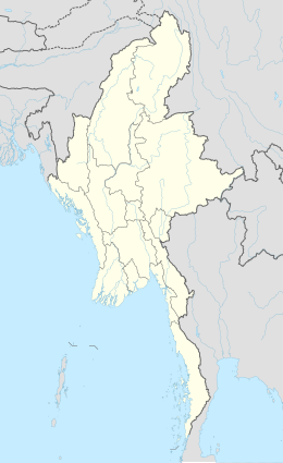
Aruba is an island and a constituent country of the Kingdom of the Netherlands in the southern Caribbean Sea, located about 1,600 kilometres (990 mi) west of the main part of the Lesser Antilles and 29 kilometres (18 mi) north of the coast of Venezuela. It measures 32 kilometres (20 mi) long from its northwestern to its southeastern end and 10 kilometres (6 mi) across at its widest point. Together with Bonaire and Curaçao, Aruba forms a group referred to as the ABC islands. Collectively, Aruba and the other Dutch islands in the Caribbean are often called the Dutch Caribbean.

The Canary Islands is a Spanish archipelago and the southernmost autonomous community of Spain located in the Atlantic Ocean, 100 kilometres west of Morocco at the closest point. The Canary Islands, which are also known informally as the Canaries, are among the outermost regions (OMR) of the European Union proper. It is also one of the eight regions with special consideration of historical nationality recognized as such by the Spanish Government. The Canary Islands belong to the African Plate like the Spanish cities of Ceuta and Melilla, the two on the African mainland.

Honolulu is the capital and largest city of the U.S. state of Hawaiʻi. It is an unincorporated part of and the county seat of the City and County of Honolulu along the southeast coast of the island of Oʻahu. The city is the main gateway to Hawaiʻi and a major portal into the United States. The city is also a major hub for international business, military defense, as well as famously being host to a diverse variety of east-west and Pacific culture, cuisine, and traditions.

Nassau is the capital and commercial centre of the Commonwealth of the Bahamas. The city has an estimated population of 274,400 as of 2016, just over 70% of the population of the country (≈391,000). Lynden Pindling International Airport, the major airport for the Bahamas, is located about 16 kilometres (9.9 mi) west of Nassau city centre, and has daily flights to major cities in Canada, the Caribbean, the United Kingdom and the United States. The city is located on the island of New Providence, which functions much like a business district. Nassau is the site of the House of Assembly and various judicial departments and was considered historically to be a stronghold of pirates. The city was named in honour of William III of England, Prince of Orange-Nassau, deriving its name from Nassau, Germany.

Rhode Island, officially the State of Rhode Island and Providence Plantations, is a state in the New England region of the United States. It is the smallest state in area, the seventh least populous, the second most densely populated, and it has the longest official name of any state. Rhode Island is bordered by Connecticut to the west, Massachusetts to the north and east, and the Atlantic Ocean to the south via Rhode Island Sound and Block Island Sound. It also shares a small maritime border with New York. Providence is the state capital and most populous city in Rhode Island.

The Virgin Islands are geologically and biogeographically the easternmost part of the Greater Antilles, the northern islands belonging to the Puerto Rican Bank and St. Croix being a displaced part of the same geologic structure. Politically, the British Virgin Islands have been governed as the western island group of the Leeward Islands, which are the northern part of the Lesser Antilles, and form the border between the Caribbean Sea and the Atlantic Ocean. The archipelago is separated from the true Lesser Antilles by the Anegada Passage and from the main island of Puerto Rico by the Virgin Passage.

Easter Island is a Chilean island in the southeastern Pacific Ocean, at the southeasternmost point of the Polynesian Triangle in Oceania. Easter Island is most famous for its nearly 1,000 extant monumental statues, called moai, created by the early Rapa Nui people. In 1995, UNESCO named Easter Island a World Heritage Site, with much of the island protected within Rapa Nui National Park.

Malé is the capital and most populous city in the Republic of Maldives. With a population of 133,412 and an area of 9.27 square kilometres (3.58 sq mi), it is also one of the most densely populated cities in the world. The city is geographically located at the southern edge of North Malé Atoll. Administratively, the city consists of a central island, an airport island, and two other islands governed by the Malé City Council.

The island of Maui is the second-largest of the Hawaiian Islands at 727.2 square miles (1,883 km2) and is the 17th largest island in the United States. Maui is part of the State of Hawaii and is the largest of Maui County's four islands, which include Molokaʻi, Lānaʻi, and unpopulated Kahoʻolawe. In 2010, Maui had a population of 144,444, third-highest of the Hawaiian Islands, behind that of Oʻahu and Hawaiʻi Island. Kahului is the largest census-designated place (CDP) on the island with a population of 26,337 as of 2010 and is the commercial and financial hub of the island. Wailuku is the seat of Maui County and is the third-largest CDP as of 2010. Other significant places include Kīhei, Lahaina, Makawao, Pukalani, Pāʻia, Kula, Haʻikū, and Hāna.

The Western Hemisphere is a geographical term for the half of Earth which lies west of the prime meridian and east of the antimeridian. The other half is called the Eastern Hemisphere.
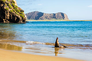
The Galápagos Islands, part of the Republic of Ecuador, are an archipelago of volcanic islands distributed on either side of the equator in the Pacific Ocean surrounding the centre of the Western Hemisphere, 906 km (563 mi) west of continental Ecuador. The islands are known for their large number of endemic species and were studied by Charles Darwin during the second voyage of HMS Beagle. His observations and collections contributed to the inception of Darwin's theory of evolution by means of natural selection.

The Toronto Islands are a chain of 15 small islands in Lake Ontario, south of mainland Toronto, Ontario, Canada. Comprising the only group of islands in the western part of Lake Ontario, the Toronto Islands are located just offshore from the city centre, and provide shelter for Toronto Harbour. The islands are home to parkland, the Billy Bishop Toronto City Airport, several yacht clubs, Centreville Amusement Park, and Hanlan's Beach. The island community is considered to be the largest urban car-free community in North America, although some service vehicles are permitted. Access to the Islands is by ferry, including the City of Toronto ferries operating from Jack Layton Ferry Terminal at the foot of Bay Street, or by water taxis.
A capital city is the municipality exercising primary status in a country, state, province, or other administrative region, usually as its seat of government. A capital is typically a city that physically encompasses the government's offices and meeting places; the status as capital is often designated by its law or constitution. In some jurisdictions, including several countries, the different branches of government are located in different settlements. In some cases, a distinction is made between the official (constitutional) capital and the seat of government, which is in another place.

Saint Thomas is one of the Virgin Islands in the Caribbean Sea and, together with Saint John, Water Island, Hassel Island and Saint Croix, a former Danish colony, form a county and constituent district of the United States Virgin Islands (USVI), an unincorporated territory of the United States. Located on the island is the territorial capital and port of Charlotte Amalie. As of the 2010 census, the population of Saint Thomas was 51,634 about 48.5% of the US Virgin Islands total. The district has a land area of 32 square miles (83 km2).

North Sumatra is a province of Indonesia. It is located in the northwest of the island of Sumatra, and its capital is Medan. North Sumatra is the fourth most populous province in Indonesia after West Java, East Java and Central Java and the most populous Indonesian province outside Java, with over 13.5 million inhabitants in 2014.

Roatán is an island in the Caribbean, about 65 kilometres (40 mi) off the northern coast of Honduras. It is located between the islands of Útila and Guanaja, and is the largest of the Bay Islands of Honduras.
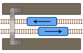
A side platform is a platform positioned to the side of a pair of tracks at a railway station, tram stop, or transitway. Dual side platform stations, one for each direction of travel, is the basic station design used for double-track railway lines. Side platforms may result in a wider overall footprint for the station compared with an island platform where a single width of platform can be shared by riders using either track.
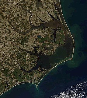
The Outer Banks is a 200-mile-long (320 km) string of barrier islands and spits off the coast of North Carolina and southeastern Virginia, on the east coast of the United States. They cover most of the North Carolina coastline, separating Currituck Sound, Albemarle Sound, and Pamlico Sound from the Atlantic Ocean.