Wa Kyun

Last updated

Wa Kyun
Island
Myanmar adm location map.svg
Red pog.svg
Wa Kyun
Coordinates: 15°12′N97°43′E / 15.200°N 97.717°E / 15.200; 97.717
Country Myanmar
State Mon
Area
  Total 3.5 km2 (1.4 sq mi)
Elevation 135 m (443 ft)
Time zone Myanmar Standard Time (UTC+6:30)

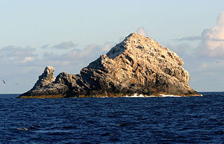
Wa Kyun is an island in the Andaman Sea, right off the coast of Mon State, in the southern area of Burma. This 2 kilometres (1.2 mi) long island is located in the midst of a shoal or shallow area. It is covered with dense forest and rises to a height of 135 metres (443 ft).

Andaman Sea Marginal sea of the eastern Indian Ocean

The Andaman Sea is a marginal sea of the eastern Indian Ocean separated from the Bay of Bengal by the Andaman Islands of India and Myanmar and the Nicobar Islands of India and touching Myanmar, Thailand, and the Malay Peninsula. Its southernmost end is defined by Breueh Island, an island just north of Sumatra.

Mon State State in South, Myanmar

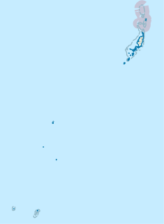
Mon State is an administrative division of Myanmar. It lies between Kayin State to the east, the Andaman Sea to the west, Bago Region to the north and Tanintharyi Region to the south, also having a short border with Thailand's Kanchanaburi Province at its south-eastern tip. The land area is 12,155 km2. The Dawna Range, running along the eastern side of the state in a NNW–SSE direction, forms a natural border with Kayin State. Mon State includes some small islands, such as Kalegauk, Wa Kyun and Kyungyi Island, along its 566 km of coastline. The state's capital is Mawlamyine.

Shoal A natural landform that rises from the bed of a body of water to near the surface and is covered by unconsolidated material

In oceanography, geomorphology, and earth sciences, a shoal is a natural submerged ridge, bank, or bar that consists of, or is covered by, sand or other unconsolidated material, and rises from the bed of a body of water to near the surface. Often it refers to those submerged ridges, banks, or bars that rise near enough to the surface of a body of water as to constitute a danger to navigation. Shoals are also known as sandbanks, sandbars, or gravelbars. Two or more shoals that are either separated by shared troughs or interconnected by past or present sedimentary and hydrographic processes are referred to as a shoal complex.

Contents

Geography

Wa Kyun is in the center of a chain of small coastal islands that lie off the mouth of the Ye River. The island of Kokunye Kyun is located 10 kilometres (6.2 mi) to the north of Wa Kyun. [1]

The Ye River is a river of Burma. It has its source in the Tenasserim Hills and drains into the Andaman Sea along the Mon State coast. Wa Kyun is an island located 3 kilometres west-northwest of the mouth of the Ye River. The Ye River flows through the eastern part of the town of Ye town.

Kokunye Kyun Island in Mon, Myanmar

Kokunye Kyun is an island in the Andaman Sea, right off the coast of Mon State, in the southern area of Burma. It is located in an area of shoals. This island is 1.4 kilometres (0.87 mi) long and its maximum width is 0.4 kilometres (0.25 mi). It is covered with dense forest and rises to a height of 140 metres (460 ft).

Nearby islands

There are three smaller islands located on the same shoal as Wa Kyun:

See also

Related Research Articles

Geography of Myanmar

Myanmar is the northwestern-most country of mainland Southeast Asia. It lies along the Indian and Eurasian Plates, to the southeast of the Himalayas. To its west is the Bay of Bengal and to its south is the Andaman Sea. It is strategically located near major Indian Ocean shipping lanes. The neighboring countries are China, India, Bangladesh, Thailand and Laos.

Gardner Pinnacles Two barren rock outcrops surrounded by a reef in the Northwestern Hawaiian Islands

The Gardner Pinnacles are two barren rock outcrops surrounded by a reef and located in the Northwestern Hawaiian Islands at 24°59′56″N167°59′58″W.

The Zhongsha Islets is a Chinese term for a collection of two skerries, many entirely submerged banks, seamounts, and shoals in the South China Sea. There are in fact, no islands in the Macclesfield Bank, the main part of Zhongsha. The Scarborough Shoal, which consists of two skerries, is not contiguous with the Macclesfield Bank but Chinese sources treat them as one chain of geographical features. The whole of the region is claimed by both the PRC and the ROC, and various bits of the eastern parts are claimed by the Philippines. No country has constant control of the whole region, and there are disputes - for example, see Scarborough Shoal standoff.

Kayangel State in Palau

Kayangel (Ngcheangel) is the northernmost state of Palau 24 km (15 mi) north of Koror. The land area is about 1.4 km2 (0.54 sq mi). The population is 138. The state consists of three atolls in different states of development:

Tuscan Archipelago island group

The Tuscan Archipelago is a chain of islands between the Ligurian Sea and Tyrrhenian Sea, west of Tuscany, Italy.

Cheduba Island Island in Rakhine, Myanmar

Cheduba Island is an island in the Bay of Bengal close to Ramree Island and belongs to Myanmar, formerly Burma. It has a maximum length of 33 km (21 mi), with an area of approximately 523 km2 (202 sq mi)

Ramree Island Island in Rakhine State, Myanmar

Ramree Island is an island off the coast of Rakhine State, Myanmar (Burma). The area of the island is about 1,350 square kilometres (520 sq mi) and the main populated center is Ramree.

The Islas Los Frailes are an archipelago of rock islets with sparse scrub vegetation belonging to the Federal dependencies of Venezuela, part of Venezuela.

Pedro Bank Submerged bank in Nicaragua Rise, Caribbean

Pedro Bank is a large bank of sand and coral, partially covered with seagrass, about 80 km south and southwest of Jamaica, rising steeply from a seabed of 800 metres depth. It slopes gently from Pedro Cays to the west and north with depths from 13 to 30 metres. The total area of the bank within the 100-metre (328-foot) isobath measures 8,040 square kilometres. The area of a depth to 40 metres is triangular, 70 kilometres long east-west, and 43 kilometres wide. 2,400 square kilometres are less than 20 metres deep. With its islets, cays and rocks, a total land area of 270,000 m2 (2,906,256 sq ft), it is the location of one of the two offshore island groups of Jamaica, the other one being the Morant Cays. The bank is centered at 17°06′N78°20′W.

Bentinck Kyun island in Myanmar

Bentinck Kyun is an island in the Mergui Archipelago, Burma (Myanmar). It lies 14 km west of Letsok-aw Kyun in the Andaman Sea. Bentinck has a very irregular indented shape. The island is thickly wooded and its area is 78 km².

Kalegauk Island Island in Mon, Myanmar

Kalegauk Island is an island in Ye Township, Mon State, Burma (Myanmar). It is located in the Andaman Sea, 8.25 kilometres (5.13 mi) from the coast of Mon State.

Kyungyi Island Island in Mon, Myanmar

Kyungyi Island is an island in the Andaman Sea, right off the coast of Mon State, in the southern area of Burma.

Moscos Islands Island group in Tanintharyi, Myanmar

The Moscos Islands are an island chain in the Andaman Sea, right off the northern coast of the Tanintharyi Region, in the southern area of Burma.

Christie Island island in Myanmar

Christie Island is an island in the Mergui Archipelago and the southernmost point of Burma (Myanmar). It lies at the southern end of the archipelago 18 km (11 mi) to the NNE of Ko Surin Nuea, and the Thai-Burmese oceanic border is located between these two islands.

Myingyi Kyun Island in Ayeyarwady, Myanmar

Myingyi Kyun, also known as High Island, is a small island off the coast of Ayeyarwady Region, Burma.

Be-in Kyun Island in Rakhine, Myanmar

Be-in Kyun, also known as Abhay Island, is a small island off the coast of Rakhine State, Burma.

Gwa Kyun Island in Rakhine, Myanmar

Gwa Kyun, also known as Gwa Chaung, is a small island off the coast of Rakhine State, Burma.

References

  1. Prostar Sailing Directions 2005 India & Bay of Bengal Enroute By National Geospatial-intelligence Agency