Myanmar is the northwestern-most country of mainland Southeast Asia. It lies along the Indian and Eurasian Plates, to the southeast of the Himalayas. To its west is the Bay of Bengal and to its south is the Andaman Sea. It is strategically located near major Indian Ocean shipping lanes.The neighboring countries are China, India, Bangladesh, Thailand and Laos.

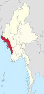
Thandwe (Burmese: သံတွဲမြို့; MLCTS: samtwai: mrui.[θàɴdwɛ́ mjo̰]; formerly Sandoway) is a town and major seaport in Rakhine State, the westernmost part of Myanmar. Thandwe is very ancient, and is said to have been at one time the capital of Rakhine State, then called Arakan. The district has an area of 3,784 square miles (9,800 km2). The country is mountainous, the Arakan Mountains sending out spurs which reach the coast. Some of the peaks in the north attain 4,000 and more ft. The streams are only mountain torrents to within a few miles of the coast; the mouth of the Khwa forms a good anchorage for vessels of from 9 to 10 ft (3.0 m). draught. The rocks in the Arakan Range and its spurs are metamorphic, and comprise clay, slates, ironstone and indurated sandstone; towards the south, ironstone, trap and rocks of basaltic character are common; veins of steatite and white fibrous quartz are also found. Between 1961 and 1990, the mean annual rainfall was 5,323 millimetres (209.6 in). Except a few acres of tobacco, all the cultivation is rice.

Cheduba Island is an island in the Bay of Bengal close to Ramree Island and belongs to Myanmar, formerly Burma. It has a maximum length of 33 km (21 mi), with an area of approximately 523 km2 (202 sq mi)

Ramree Island is an island off the coast of Rakhine State, Burma. The area of the island is about 1,350 square kilometres (520 sq mi) and the main populated center is Ramree.

Manaung is a township of Kyaukpyu District in the Rakhine State of Western Myanmar. The principal town is Manaung. Manaung Township, situated on Manaung Island consists of three islands: Manaung Island, Ye Kyun Island and Taik Kyun Island. Manaung is not only a township of Kyaukpyu District but also the second biggest island of Rakhine State in Myanmar.
Taungup or Toungup Township is a coastal township of Thandwe District in the Rakhine State of Myanmar. The administrative centre and principal town is Toungup. The only other town is Ma-Ei.

Kanmaw Kyun or Kanmaw Island is an island in the Andaman Sea along the coast of southeastern Burma (Myanmar), and is part of the Mergui Archipelago. Administratively, it is located in Kyunsu Township, Myeik District, in the Taninthayi Region. On the northeastern side of the island is the town of Kyunsu which is the administrative seat for the township. The island covers a total area of 409 km².
Myingun Island, also known as Myengu Island, is an island in the Bay of Bengal. It is administrated by Myanmar and belongs to Rakhine State. The island is located 5 kilometres to the south of Sittwe, separated from the continental shore by a 2-kilometre-wide (1.2 mi) strait.
Kalegauk Island is an island in Ye Township, Mon State, Burma (Myanmar). It is located in the Andaman Sea, 8.25 kilometres (5.13 mi) from the coast of Mon State.
Wa Kyun is an island in the Andaman Sea, right off the coast of Mon State, in the southern area of Burma. This 2 kilometres (1.2 mi) long island is located in the midst of a shoal or shallow area. It is covered with dense forest and rises to a height of 135 metres (443 ft).
Kyungyi Island is an island in the Andaman Sea, right off the coast of Mon State, in the southern area of Burma.
Kokunye Kyun is an island in the Andaman Sea, right off the coast of Mon State, in the southern area of Burma. It is located in an area of shoals. This island is 1.4 kilometres (0.87 mi) long and its maximum width is 0.4 kilometres (0.25 mi). It is covered with dense forest and rises to a height of 140 metres (460 ft).

The Moscos Islands are an island chain in the Andaman Sea, right off the northern coast of the Tanintharyi Region, in the southern area of Burma.
Nantha Kyun is an island off the coast of Rakhine State, Burma.
Unguan is a small island off the coast of Rakhine State, Myanmar.
Zalat Taung is an island off the coast of Rakhine State, Burma.
Myingyi Kyun, also known as High Island, is a small island off the coast of Ayeyarwady Region, Burma.
Be-in Kyun, also known as Abhay Island, is a small island off the coast of Rakhine State, Burma.
Gwa Kyun, also known as Gwa Chaung, is a small island off the coast of Rakhine State, Burma.