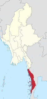
Myanmar is the northwestern-most country of mainland Southeast Asia. It lies along the Indian and Eurasian Plates, to the southeast of the Himalayas. To its west is the Bay of Bengal and to its south is the Andaman Sea. It is strategically located near major Indian Ocean shipping lanes. The neighboring countries are China, India, Bangladesh, Thailand and Laos.
Tak is one of the western provinces (changwat) of Thailand. Neighbouring provinces are Mae Hong Son, Chiang Mai, Lamphun, Lampang, Sukhothai, Kamphaeng Phet, Nakhon Sawan, Uthai Thani and Kanchanaburi. The western edge of the province has a long boundary with Kayin State of Myanmar (Burma).

The Great Nicobar Biosphere Reserve encompasses a large part of the island of Great Nicobar, the largest of the Nicobar Islands in the Indian Union Territory of Andaman and Nicobar Islands. The Nicobars lie in the Bay of Bengal, eastern Indian Ocean, 190 km to the north of the Indonesian island of Sumatra. The Reserve has a total core area of approximately 885 km2, surrounded by a 12 km-wide "forest buffer zone".In year 2013 it was included in the list of Man and Biosphere program of UNESCO to promote sustainable development based on local community effort and sound science.
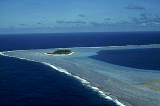
Rose Atoll, sometimes called Rose Island or Motu O Manu by people of the nearby Manu'a Islands, is an oceanic atoll within the U.S. territory of American Samoa. It is an uninhabited wildlife refuge. It is the southernmost point belonging to the United States. The land area is 0.214 km2. The total area of the atoll, including lagoon and reef flat amounts to 5 km2. Just west of the northernmost point is a channel into the lagoon, about 40 m wide. There are two islets on the northeastern rim of the reef, larger Rose Island in the east and the non-vegetated Sand Island in the north.

The Surin Islands is an archipelago of five islands in the Andaman Sea, 60 km from the Thai mainland. Administratively, the islands are part of Tambon Ko Phra Thong, Khura Buri District, in Phang Nga Province, Thailand.

Turtle Islands Park is located within the Turtle Islands, which lie in the Sulu Sea some 3 kilometres north of Sandakan in Sabah, Malaysia. It consists of 3 islands - Selingaan, Little Bakkungan and Gulisaan, including the surrounding coral reefs and ocean. The Park is noted for its green turtles and hawksbill turtles which lay their eggs on the beaches of the islands. The Park covers an area of 17.4 km². The name Turtle Islands, however, refers to 10 islands, 3 of which are part of Turtle Islands Park of Malaysia, and 7 which belong to the Turtle Islands Wildlife Sanctuary of Tawi-Tawi province, Philippines.
South Button Island National Park is a national park located in the Andaman and Nicobar Islands off the coast of India, the total area of this protected island is about 5 km2 (2 sq mi). Along with the neighbouring islands of North Button and Middle Button, both also national parks, it forms part of the Rani Jhansi Marine National Park off the coast of South Andaman Island.

The red-crowned roofed turtle is a species of freshwater turtle endemic to South Asia. It was the type species of its former genus Kachuga. Females can grow to a shell length of 56 cm (22 in) and weigh 25 kilograms (55 lb), but males are considerably smaller. The turtles like to bask in the sun on land. In the breeding season, the heads and necks of male turtles exhibit bright red, yellow and blue coloring. The females excavate nests in which they lay clutches of up to thirty eggs.

Bhitarkanika Mangroves is a mangrove wetland in Odisha, covering an area of 650 km (400 mi) in the Brahmani and Baitarani river deltas.
Gahirmatha Beach is a beach in the Indian state of Odisha. The beach separates the Bhitarkanika mangroves from the Bay of Bengal and is the world's most important nesting beach for Olive Ridley Sea Turtles. The beach is part of Gahirmatha Marine Wildlife Sanctuary, which also includes the adjacent portion of the Bay of Bengal.

Mu Ko Phetra is a marine national park in the Strait of Malacca off Thailand, covering mostly intact coastal line, open water, and about 30 islands of the southern part of Trang Province and the northern part of Satun Province. Established on 31 December 1984, it is the 49th national park and 14th marine national park of Thailand.

Chimmini Wildlife sanctuary is a national park located along the Western Ghats in Chalakudy taluk of Thrissur District of Kerala state in India.

The Ilhéus do Rombo, also known as the Ilhéus Secos, are a group of small, uninhabited islands in the Cape Verde archipelago, lying 600 km off the coast of north-west Africa in the Atlantic Ocean. The islets form an integral nature reserve. They are sited on a volcanic seamount 7 km north of Brava and 15 km west of Fogo. The two major islets of the chain are Ilhéu Grande (300 ha) and Ilhéu de Cima (150 ha). Administratively they are part of the municipality of Brava. They can be seen from Brava and, sometimes, from Fogo.
Metinic Island is a 330 acres (130 ha) island in Knox County, Maine, southeast of Port Clyde on the mainland and west of Matinicus Island. The island is part of the Plantation of Matinicus Isle.
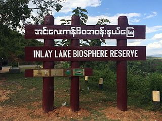
Inlay Lake Wetland Sanctuary is a wildlife reserve located in Inlay Lake of Shan State, Burma. It occupies an area of 642.32 square miles (1,660 km2) and was established in 1985 and designated as one of ASEAN Heritage Parks in 2003. It is part of 1891 square miles wide Inle World Network of Biosphere Reserves site. It located between 20° 10' N and 97° 02' E in Nyaungshwe, Pinlaung and Pekon Township of Taunggyi District. Its elevation is over 2,900 feet.

Kabosa Island is an island in the Mergui Archipelago, Burma (Myanmar). It is a 7 km long and roughly square-shaped island located at the northwestern end of the archipelago 15 km to the north of Tenasserim Island. Kabosa is a hilly and thickly wooded island with four conspicuous mountains reaching a maximum height of 396 m.

Wa Kyun is an island in the Andaman Sea, right off the coast of Mon State, in the southern area of Burma. This 2 kilometres (1.2 mi) long island is located in the midst of a shoal or shallow area. It is covered with dense forest and rises to a height of 135 metres (443 ft).
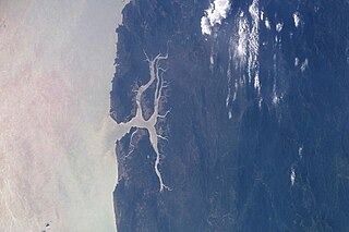
The Heinze River is a river of Burma. It has its source in the Tenasserim Hills and ends in the Andaman Sea in the Tanintharyi Region coast. The Heinze Islands is a small island group located 25 km to the SSW of the mouth of the Heinze River.
Dhamra is a joint stream in Odisha that is formed by the confluence of the Brahmani and Baitarani rivers south of the town of Chandabali. It lies in the Bhadrak district and empties into the Bay of Bengal. To the north of its mouth is the Dhamra Port and near the mouth is the Gahirmatha sanctuary, a nesting site for olive ridley sea turtles.