
Myanmar is the northwestern-most country of mainland Southeast Asia. It lies along the Indian and Eurasian Plates, to the southeast of the Himalayas. To its west is the Bay of Bengal and to its south is the Andaman Sea. It is strategically located near major Indian Ocean shipping lanes.The neighboring countries are China, India, Bangladesh, Thailand and Laos.

North Korea is located in East Asia on the Northern half of the Korean Peninsula.

Bangladesh is a densely-populated, low-lying, mainly riverine country located in South Asia with a coastline of 580 km (360 mi) on the northern littoral of the Bay of Bengal. The delta plain of the Ganges (Padma), Brahmaputra (Jamuna), and Meghna Rivers and their tributaries occupy 79 percent of the country. Four uplifted blocks occupy 9 percent, and steep hill ranges up to ca 1,000 m high occupy 12 percent in the southeast and in the northeast. Straddling the Tropic of Cancer, Bangladesh has a tropical monsoon climate characterised by heavy seasonal rainfall, high temperatures, and high humidity. Natural disasters such as floods and cyclones accompanied by storm surges periodically affect the country. Most of the country is intensively farmed, with rice the main crop, grown in three seasons. Rapid urbanisation is taking place with associated industrial and commercial development. Exports of garments and shrimp plus remittances from Bangladeshis working abroad provide the country's three main sources of foreign exchange income.

Aconcagua, with a summit elevation of 6,960.8 metres (22,837 ft), is the highest mountain in both the Southern and Western Hemispheres. It is located in the Andes mountain range, in the Mendoza Province, Argentina, and lies 112 km (70 mi) northwest of its capital, the city of Mendoza, about five km (3.1 mi) from San Juan Province and 15 km (9.3 mi) from the international border with Chile. The mountain itself lies entirely within Argentina, immediately east of Argentina's border with Chile. Its nearest higher neighbor is Tirich Mir in the Hindu Kush, 16,520 kilometres (10,270 mi) away. It is one of the Seven Summits.
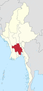
Bago Region is an administrative region of Myanmar, located in the southern central part of the country. It is bordered by Magway Region and Mandalay Region to the north; Kayin State, Mon State and the Gulf of Martaban to the east; Yangon Region to the south and Ayeyarwady Region and Rakhine State to the west. It is located between 46°45'N and 19°20'N and 94°35'E and 97°10'E. It has a population of 4,867,373 (2014).
Kayangel (Ngcheangel) is the northernmost state of Palau 24 km (15 mi) north of Koror. The land area is about 1.4 km2 (0.54 sq mi). The population is 138. The state consists of three atolls in different states of development:

Cheduba Island is an island in the Bay of Bengal close to Ramree Island and belongs to Myanmar, formerly Burma. It has a maximum length of 33 km (21 mi), with an area of approximately 523 km2 (202 sq mi)

Ramree Island is an island off the coast of Rakhine State, Burma. The area of the island is about 1,350 square kilometres (520 sq mi) and the main populated center is Ramree.
The Coco Islands are a small group of islands in the northeastern Bay of Bengal. They are part of the Yangon Region of Myanmar. The islands are located 414 km (257 mi) south of the city of Yangon. Cocos Island group consists of 5 islands, 4 islands on Great Coco Reef and another solaitary island on the Little Coco Reef. To the north of this island group lies Preparis Island also belonging to Myanmar, and to the south lies the Landfall Island belonging to India.

Khawsa is a town in Ye Township in Mawlamyine District in the Mon State of southern Myanmar. Khawsa lies on the Khawsa Chaung about 5 kilometres (3.1 mi) from the coast of the Andaman Sea. It is protected from the sea by a 259 metres (850 ft) hill and the 860 metres (2,822 ft) Mount Pawdaing rises to the east.
Wa Kyun is an island in the Andaman Sea, right off the coast of Mon State, in the southern area of Burma. This 2 kilometres (1.2 mi) long island is located in the midst of a shoal or shallow area. It is covered with dense forest and rises to a height of 135 metres (443 ft).
Kyungyi Island is an island in the Andaman Sea, right off the coast of Mon State, in the southern area of Burma.
Kokunye Kyun is an island in the Andaman Sea, right off the coast of Mon State, in the southern area of Burma. It is located in an area of shoals. This island is 1.4 kilometres (0.87 mi) long and its maximum width is 0.4 kilometres (0.25 mi). It is covered with dense forest and rises to a height of 140 metres (460 ft).

The Geography of Franz Josef Land refers to an island group belonging to Arkhangelsk Oblast of Russia. It is situated in the Barents Sea of the Arctic, north of Novaya Zemlya and east of Svalbard. At latitudes between 80.0° and 81.9° north, it is the most northerly group of islands associated with Eurasia. The extreme northernmost point is Cape Fligely on Rudolf Island. The archipelago consists of 191 ice-covered islands with a total area of 16,134 km2 (6,229 sq mi). It is currently uninhabited. The archipelago is only 900 to 1,110 km from the North Pole, and the northernmost islands are closer to the Pole than any other land except for Canada's Ellesmere Island and Greenland. The largest island is Zemlya Georga which measures 110 km (68 mi) from end to end. The highest point in the archipelago is on Ostrov Viner-Neyshtadt which reaches 620 m (2,034 ft) above sea level. The central cluster of large islands in the midst of the archipelago forms a compact whole, known as Zichy Land, where islands are separated from each other by very narrow sounds that are frozen most of the year.

The geography of the Heard Island and McDonald Islands (HIMI) refers to the geography of Heard Island and the McDonald Islands, one of the most remote places on earth. The islands belong to Australia and are located 4,000 kilometres (2,485.5 mi) southwest of the mainland in the Southern Ocean. These subantarctic islands were transferred to Australia by the United Kingdom in 1947. They lie between Madagascar and Antarctica.
Nantha Kyun is an island off the coast of Rakhine State, Burma.
The Calventuras Islands are a small group of islands off the coast of Ayeyarwady Region, Burma.
Myingyi Kyun, also known as High Island, is a small island off the coast of Ayeyarwady Region, Burma.


