
Myanmar is the northwestern-most country of mainland Southeast Asia. It lies along the Indian and Eurasian Plates, to the southeast of the Himalayas. To its west is the Bay of Bengal and to its south is the Andaman Sea. It is strategically located near major Indian Ocean shipping lanes.The neighboring countries are China, India, Bangladesh, Thailand and Laos.

Myeik, is a city in Tanintharyi Region in Myanmar (Burma), located in the extreme south of the country on the coast of an island on the Andaman Sea. As of 2010 the estimated population was over 209,000. The area inland from the city is a major smuggling corridor into Thailand. The Singkhon Pass, also known as the Maw-daung Pass, has an international cross-border checkpoint.
Kadan Kyun is the largest island in the Mergui Archipelago, Myanmar. Its area is 450 km². The highest point is French Bay Peak, which is the highest point in the archipelago.
Letsok-aw Island is an island in the Mergui Archipelago, Burma (Myanmar). With a length of 38 km and an area of 250 km² it is one of the largest islands of the archipelago. This hilly and thickly wooded island lies 14 km east of Bentinck Kyun. It stretches from north to south and has a maximum width of 9.7 km. Highest point 683 m.

Lanbi Kyun, also Lambi Island and Lampi Island, is an island in the Mergui Archipelago, Burma. Having an area of 188 km2 (73 sq mi), thickly wooded Lanbi is one of the largest islands of the group.

Thayawthadangyi Kyun, also known as Elphinstone Island, is an island in the Mergui Archipelago, Burma.
Mali Kyun is an island in the Mergui Archipelago, Burma (Myanmar). This long and narrow island at the northern end of the archipekago occupies an area of 99 km2 (38 sq mi), stretching roughly from north to south.
Bentinck Kyun is an island in the Mergui Archipelago, Burma (Myanmar). It lies 14 km west of Letsok-aw Kyun in the Andaman Sea. Bentinck has a very irregular indented shape. The island is thickly wooded and its area is 78 km².
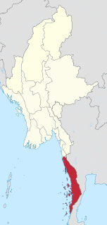
Tanintharyi Region is an administrative region of Myanmar, covering the long narrow southern part of the country on the Kra Isthmus. It borders the Andaman Sea to the west and the Tenasserim Hills, beyond which lie Thailand, to the east. To the north is the Mon State. There are many islands off the coast, the large Mergui Archipelago in the southern and central coastal areas and the smaller Moscos Islands off the northern shores. The capital of the division is Dawei (Tavoy). Other important cities include Myeik (Mergui) and Kawthaung. The division covers an area of 43,344.9 km², and had a population of 1,406,434 at the 2014 Census.
Andaman Club is a five-star island casino and golf resort in Burma. It is located on 730 ha of Thahtay Kyun Island within the Mergui Archipelago in the Andaman Sea. Directly adjacent to Ranong, in the south of Thailand and to King Bayint Nbung is a region famous for its gems, pearls, flora and fauna. The pier is 5 kilometres (3.1 mi) from the Ranong city centre and it takes 20 minutes to cross the Andaman Sea to the island resort. It is owned and operated by the VES Group of Thailand, under a long-term concession from the Burmese government.
Thahtay Island, also known as Thahtay Kyun and Son Island, is a small Burmese island within the Mergui Archipelago in the Andaman Sea. The island is directly adjacent to Ranong, a city in the south of Thailand and to Kawthaung. The island has been given by the Burmese government on a long term concession to a Thailand-based VES Group for development as a tourism. Grand Andaman is a five star casino club golf resort now operating on the island.

Kyunsu, better known as Kanmaw, is a small town in the Mergui Archipelago of south-eastern Burma. It is the principal town of Kyunsu Township in Myeik District which since 1990 has covered much of the archipelago. The town lies on the north-eastern coast of Kanmaw Kyun, south-west of Myeik (Mergui).

Kanmaw Kyun or Kanmaw Island is an island in the Andaman Sea along the coast of southeastern Burma (Myanmar), and is part of the Mergui Archipelago. Administratively, it is located in Kyunsu Township, Myeik District, in the Taninthayi Region. On the northeastern side of the island is the town of Kyunsu which is the administrative seat for the township. The island covers a total area of 409 km².
Money Island or Ngwe Kyun is an island in the Mergui Archipelago of Taninthayi Region, Myanmar.
Zadetkyi Island or Zadetkyi Kyun, also known as Saint Matthew's Island, is an island at the southern end of the Mergui Archipelago, Burma. Its northern side forms the southern shore of Hastings Harbor, where there is a base of the Myanmar Navy.
Than Kyun or Davis Island is an island at the southern end of the Mergui Archipelago, Burma. It is the largest and highest island of the Alladin Islands, a scattered cluster of islands extending to the W and SSW of Zadetkyi Island. This densely wooded island has two main peaks, each with a height of around 450 metres. The island has a roughly round shape with a diameter of about 6 kilometres. Off its eastern shore rises a 5.5-metre-high (18.0-foot) rock surrounded by a reef. Than Kyun lies 4.5 kilometres west of the southern end of Zadetkyi Island.
Christie Island is an island in the Mergui Archipelago and the southernmost point of Burma (Myanmar). It lies at the southern end of the archipelago 18 km (11 mi) to the NNE of Ko Surin Nuea, and the Thai-Burmese oceanic border is located between these two islands.


