Otai-shuku

Last updated
Hiroshige's print of Otai-shuku, part of the series The Sixty-nine Stations of the Kiso Kaido Kisokaido21 Otai.jpg
Hiroshige's print of Otai-shuku, part of the series The Sixty-nine Stations of the Kiso Kaidō

Otai-shuku(小田井宿,Otai-shuku) was the twenty-first of the sixty-nine stations of the Nakasendō. It is located in the present-day town of Miyota, in the Kitasaku District of Nagano Prefecture, Japan.

69 Stations of the Nakasendō

The 69 Stations of the Nakasendō are the rest areas along the Nakasendō, which ran from Nihonbashi in Edo to Sanjō Ōhashi in Kyoto. The route stretched approximately 534 km (332 mi) and was an alternate trade route to the Tōkaidō.

Nakasendō

The Nakasendō, also called the Kisokaidō (木曾街道), was one of the five routes of the Edo period, and one of the two that connected Edo to Kyoto in Japan. There were 69 stations (staging-posts) between Edo and Kyoto, crossing through Musashi, Kōzuke, Shinano, Mino and Ōmi provinces. In addition to Tokyo and Kyoto, the Nakasendō runs through the modern-day prefectures of Saitama, Gunma, Nagano, Gifu and Shiga, with a total distance of about 534 km (332 mi).

Miyota, Nagano Town in Chūbu, Japan

Miyota is a town located in Nagano Prefecture, Japan. As of 1 April 2019, the town had an estimated population of 15,562 in 6897 households, and a population density of 258 persons per km². The total area of the town is 58.79 square kilometres (22.70 sq mi).

Contents

History

Otai-shuku originated between 473 and 492 AD and developed into a post town over one thousand years later, during the Keichō era. [1] Because Otai-shuku was small there were only five rest areas in the entire post town, daimyōs tended to stay at the neighboring Oiwake-shuku, which was much larger. [2] The Otai-shuku Festival was established to commemorate the 400th anniversary of the founding of the post town; this festival takes place on August 16 of each year. [3]

Keichō Japanese era

Keichō (慶長) was a Japanese era name after Bunroku and before Genna. This period spanned from October 1596 to July 1615. The reigning emperors were Go-Yōzei-tennō (後陽成天皇) and Go-Mizunoo-tennō (後水尾天皇).

<i>Daimyō</i> powerful territorial lord in pre-modern Japan

The daimyō were powerful Japanese feudal lords who, until their decline in the early Meiji period, ruled most of Japan from their vast, hereditary land holdings. In the term, dai (大) means "large", and myō stands for myōden(名田), meaning private land.

Oiwake-shuku

Oiwake-shuku was the twentieth of the sixty-nine stations of the Nakasendō. It is located in the present-day town of Karuizawa, in the Kitasaku District of Nagano Prefecture, Japan.

Neighboring post towns

Nakasendō
Oiwake-shuku - Otai-shuku - Iwamurada-shuku

Related Research Articles

Karuizawa, Nagano Town in Chūbu, Japan

Karuizawa is a town located in Nagano Prefecture, Japan. As of 1 October 2016, the town had an estimated population of 19,939, and a population density of 128 persons per km². Its total area is 156.03 square kilometres (60.24 sq mi). Karuizawa is a popular summer resort area for the residents of Tokyo.

Shimosuwa-shuku

Shimosuwa-shuku was the twenty-ninth of the sixty-nine stations of the Nakasendō, as well as being the ending location of the Kōshū Kaidō. It is located in the present-day town of Shimosuwa, Suwa District, Nagano Prefecture, Japan.

Wada-shuku

Wada-shuku was the twenty-eighth of the sixty-nine stations of the Nakasendō highway connecting Edo with Kyoto during the Edo period. It was located in the present-day town of Nagawa, in the Chiisagata District of Nagano Prefecture, Japan.

Nagakubo-shuku

Nagakubo-shuku was the twenty-seventh of the sixty-nine stations of the Nakasendō highway connecting Edo with Kyoto during the Edo period. It is located in the present-day town of Nagawa, in the Chiisagata District of Nagano Prefecture, Japan.

Ashida-shuku

Ashida-shuku was the twenty-sixth of the sixty-nine stations of the Nakasendō. It is located in the present-day town of Tateshina, in the Kitasaku District of Nagano Prefecture, Japan.

Mochizuki-shuku

Mochizuki-shuku was the twenty-fifth of the sixty-nine stations of the Nakasendō. It is located in the present-day city of Saku, in Nagano Prefecture, Japan.

Yawata-shuku

Yawata-shuku was the twenty-fourth of the sixty-nine stations of the Nakasendō. It is located in the present-day city of Saku, in Nagano Prefecture, Japan.

Shionada-shuku

Shionada-shuku was the twenty-third of the sixty-nine stations of the Nakasendō. It is located in the present-day city of Saku, in Nagano Prefecture, Japan.

Iwamurada-shuku

Iwamurada-shuku was the twenty-second of the sixty-nine stations of the Nakasendō. It is located in the present-day city of Saku, in Nagano Prefecture, Japan.

The Hokkoku Kaidō was a highway in Japan during the Edo period. It was a secondary route, ranked below the Edo Five Routes in importance. Because it was developed for travelers going to Zenkō-ji, it was also called Zenkō-ji Kaidō (善光寺街道). It stretched from the Nakasendō's Oiwake-juku to the Hokurikudō's Takada-shuku. Nowadays, the route is traced by Route 18, stretching between the town of Karuizawa and the city of Jōetsu.

Kutsukake-shuku

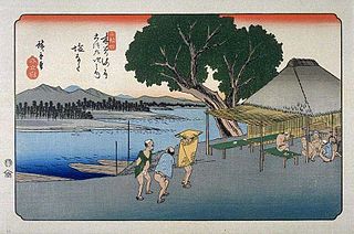
Kutsukake-shuku was the nineteenth of the sixty-nine stations of the Nakasendō. It is located in the present-day town of Karuizawa, in the Kitasaku District of Nagano Prefecture, Japan.

Okegawa-shuku

Okegawa-shuku was the sixth of the sixty-nine stations of the Nakasendō highway connecting Edo with Kyoto during the Edo period. It was located in the present-day city of Okegawa, Saitama Prefecture, Japan.

Kōnosu-shuku

Kōnosu-shuku was the seventh of the sixty-nine stations of the Nakasendō highway connecting Edo with Kyoto during the Edo period. It was located in the present-day city of Kōnosu, Saitama Prefecture, Japan.

Shinmachi-shuku

Shinmachi-shuku was the eleventh of the sixty-nine stations of the Nakasendō. It is located in the present-day city of Takasaki, Gunma Prefecture, Japan.

Itahana-shuku

Itahana-shuku was the fourteenth of the sixty-nine stations of the Nakasendō. It is located in the present-day city of Annaka, Gunma Prefecture, Japan. Ruins of its honjin can be found at the Princess Kazunomiya Inn.

Matsuida-shuku

Matsuida-shuku was the sixteenth of the sixty-nine stations of the Nakasendō. It is located in the present-day city of Annaka, Gunma Prefecture, Japan, at the foot of Mount Myōgi.

Annaka-shuku

Annaka-shuku was the fifteenth of the sixty-nine stations of the Nakasendō. It is located in the present-day city of Annaka, Gunma Prefecture, Japan. Batō Kan'on lined the way to the post town.

References

  1. Nakasendo: Otai-shuku. Shunji Mori. Accessed August 14, 2007.
  2. Nakasendō: Shinshū Miyota. Miyota-machi Tourist Association. Accessed August 30, 2007.
  3. Otai-juku Matsuri: Shinshū Miyota. Miyota-machi Tourist Association. Accessed August 14, 2007.

Coordinates: 36°18′22.2″N138°29′49.6″E / 36.306167°N 138.497111°E / 36.306167; 138.497111

Geographic coordinate system Coordinate system

A geographic coordinate system is a coordinate system that enables every location on Earth to be specified by a set of numbers, letters or symbols. The coordinates are often chosen such that one of the numbers represents a vertical position and two or three of the numbers represent a horizontal position; alternatively, a geographic position may be expressed in a combined three-dimensional Cartesian vector. A common choice of coordinates is latitude, longitude and elevation. To specify a location on a plane requires a map projection.