
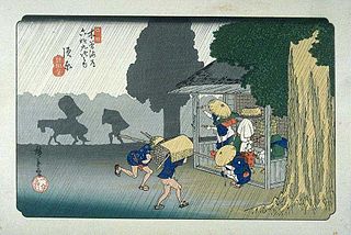
The Nakasendō, also called the Kisokaidō (木曾街道), was one of the five routes of the Edo period, and one of the two that connected Edo to Kyoto in Japan. There were 69 stations (staging-posts) between Edo and Kyoto, crossing through Musashi, Kōzuke, Shinano, Mino and Ōmi provinces. In addition to Tokyo and Kyoto, the Nakasendō runs through the modern-day prefectures of Saitama, Gunma, Nagano, Gifu and Shiga, with a total distance of about 534 km (332 mi).

Kiso is a district located in Nagano Prefecture, Japan.

Magome-juku was the forty-third of the sixty-nine stations of the Nakasendō connecting Edo with Kyoto in Edo period Japan. It is located in former Mino Province in what is now part of the city of Nakatsugawa, Gifu Prefecture, Japan. It was also the last of eleven stations along the Kisoji, which was the precursor to a part of the Nakasendō, running through the Kiso Valley.
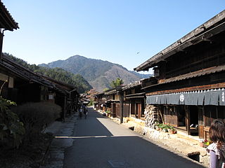
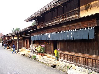
Tsumago-juku was the forty-second of the sixty-nine post towns on the Nakasendō. It is located in Nagiso, Kiso District, Nagano Prefecture, Japan. It has been restored to its appearance as an Edo-era post town and is now a popular tourist destination.
The 69 Stations of the Nakasendō are the rest areas along the Nakasendō, which ran from Nihonbashi in Edo to Sanjō Ōhashi in Kyoto. The route stretched approximately 534 km (332 mi) and was an alternate trade route to the Tōkaidō.

Unuma-juku was the fifty-second of the sixty-nine stations of the Nakasendō connecting Edo with Kyoto in Edo period Japan. It is located in former Mino Province in what is now part of the city of Kakamigahara, Gifu Prefecture, Japan.

Ōta-juku was the fifty-first of the sixty-nine stations of the Nakasendō connecting Edo with Kyoto in Edo period Japan. It is located in former Mino Province in what is now part of the city of Minokamo, Gifu Prefecture, Japan.

Ochiai-juku was the forty-fourth of the sixty-nine stations of the Nakasendō connecting Edo with Kyoto in Edo period Japan. It is located in former Mino Province in what is now part of the city of Nakatsugawa, Gifu Prefecture, Japan.

Ōi-juku was the forty-sixth of the sixty-nine stations of the Nakasendō connecting Edo with Kyoto in Edo period Japan. It is located in former Mino Province in what is now part of the city of Ena, Gifu Prefecture, Japan. From Ōi-juku to the next post town, Ōkute-juku, there are 13 hills to pass over. Travellers using the Shitakaidō (下街道) often used Ōi-juku, too, as they travelled on to Makiganetsui (槙ヶ根追) afterwards.

Midono-juku was the forty-first of the sixty-nine stations of the Nakasendō, as well as the ninth of eleven stations on the Kisoji. It is located in the present-day town of Nagiso, in the Kiso District of Nagano Prefecture, Japan. It was originally written as 御殿宿 (Midono-juku).

Toriimoto-juku (鳥居本宿) was the sixty-third of the sixty-nine stations of the Nakasendō highway connecting Edo with Kyoto in Edo period Japan. It was located in the present-day city of Hikone, Shiga Prefecture, Japan, overlooking Lake Biwa.

Niekawa-juku was the thirty-third of the sixty-nine stations of the Nakasendō. It is located in the present-day city of Shiojiri, Nagano Prefecture, Japan.
The Kisoji was an old trade route in the Kiso Valley that stretched from Niekawa-juku in Nagano Prefecture to Magome-juku in Gifu Prefecture. There were eleven resting spots along the route, all of which became part of the Nakasendō when it was established. There is an article dating from 713 in the Shoku Nihongi that records the route’s characters as 吉蘇路.

Narai-juku was the thirty-fourth of the sixty-nine stations of the Nakasendō, as well as the second of eleven stations along the Kisoji. It is located in the present-day city of Shiojiri, Nagano Prefecture, Japan.

Nojiri-juku was the fortieth of the sixty-nine stations of the Nakasendō, as well as the eighth of eleven stations on the Kisoji. It is located in the present-day village of Ōkuwa, in the Kiso District of Nagano Prefecture, Japan.
Suhara-juku was the thirty-ninth of the sixty-nine stations of the Nakasendō, as well as the seventh of eleven stations on the Kisoji. It is located in the present-day village of Ōkuwa, in the Kiso District of Nagano Prefecture, Japan.

Agematsu-juku was the thirty-eighth of the sixty-nine stations of the Nakasendō, as well as the sixth of eleven stations on the Kisoji. It is located in the present-day town of Agematsu, in the Kiso District of Nagano Prefecture, Japan. From the present-day Jūō Bridge, it runs through the Kan-machi and three other districts, but Edo period row houses from the post town can only be found in Kan-machi. The town originally flourished as a logging town under the protection of the Owari Han.

Fukushima-juku was the thirty-seventh of the sixty-nine stations of the Nakasendō highway connecting Edo with Kyoto during the Edo period. It was located in the present-day city of Kiso, in the Kiso District of Nagano Prefecture, Japan. It was also numbered as the fifth of eleven stations on the Kisoji highway.

Miyanokoshi-juku was the thirty-sixth of the sixty-nine stations of the Nakasendō, as well as the fourth of eleven stations on the Kisoji. It is located in the present-day town of Kiso, in the Kiso District of Nagano Prefecture, Japan.
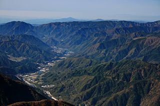
The Kiso Valley is a geographical area that centers on the valley of the upper portions of the Kiso River in the southwestern part of Nagano Prefecture in Japan. It is a v-shaped valley with length of approximately 60 km (36 mi) that follows the river as it flows from north by northwest to south by southwest into Gifu Prefecture.
