Karuisawa-shuku

Last updated
Hiroshige's print of Karuisawa-shuku, part of The Sixty-nine Stations of the Kiso Kaido series Kisokaido18 Karuisawa.jpg
Hiroshige's print of Karuisawa-shuku, part of The Sixty-nine Stations of the Kiso Kaidō series

Karuisawa-shuku(軽井沢宿,Karuisawa-shuku) was the eighteenth of the sixty-nine stations of the Nakasendō. It is located in the northern portion of the present-day town of Karuizawa, in the Kitasaku District of Nagano Prefecture, Japan. Karuisawa-shuku is 10 km (6.2 mi) from the preceding post station, Sakamoto-shuku, and 4 km (2.5 mi) from the following one, Kutsukake-shuku. [1]

69 Stations of the Nakasendō

The 69 Stations of the Nakasendō are the rest areas along the Nakasendō, which ran from Nihonbashi in Edo to Sanjō Ōhashi in Kyoto. The route stretched approximately 534 km (332 mi) and was an alternate trade route to the Tōkaidō.

Nakasendō

The Nakasendō, also called the Kisokaidō (木曾街道), was one of the five routes of the Edo period, and one of the two that connected Edo to Kyoto in Japan. There were 69 stations (staging-posts) between Edo and Kyoto, crossing through Musashi, Kōzuke, Shinano, Mino and Ōmi provinces. In addition to Tokyo and Kyoto, the Nakasendō runs through the modern-day prefectures of Saitama, Gunma, Nagano, Gifu and Shiga, with a total distance of about 534 km (332 mi).

Karuizawa, Nagano Town in Chūbu, Japan

Karuizawa is a town located in Nagano Prefecture, Japan. As of 1 October 2016, the town had an estimated population of 19,939, and a population density of 128 persons per km². Its total area is 156.03 square kilometres (60.24 sq mi). Karuizawa is a popular summer resort area for the residents of Tokyo.

Contents

History

The place that was originally called Karuisawa is, in actuality, approximately two to three kilometers from the post town, which is located at the western entrance to the Usui Pass. Karuisawa-shuku flourished more than any other post town along the Nakasendō, with five honjin and sub-honjin, in addition to over 100 other structures for travelers. During the Edo period, the post town also employed hundreds of meshimori onna (飯盛女), women who were employed by the Shōgun to serve food to travelers. To the east of the post town, a bridge crossed over the Yakazaki River, where travelers reluctantly parted with the meshimori onna.

Usui Pass mountain pass between Nagano and Gunma Prefectures in Japan

The Usui Pass is a mountain pass that lies between Nagano and Gunma Prefectures in Japan. It has served as one of the major transportation routes in central Japan since at least the eighth century.

<i>Honjin</i>

Honjin (本陣) is the Japanese word for an inn for government officials, generally located in post stations (shukuba) during the later part of the Edo period.

Edo period period of Japanese history

The Edo period or Tokugawa period (徳川時代) is the period between 1603 and 1868 in the history of Japan, when Japanese society was under the rule of the Tokugawa shogunate and the country's 300 regional daimyō. The period was characterized by economic growth, strict social order, isolationist foreign policies, a stable population, "no more wars", and popular enjoyment of arts and culture. The shogunate was officially established in Edo on March 24, 1603, by Tokugawa Ieyasu. The period came to an end with the Meiji Restoration on May 3, 1868, after the fall of Edo.

From the Meiji period onwards, Karuisawa became a popular place with Western missionaries. It was at this point that the area's name changed from "Karuisawa" to the modern "Karuizawa," which is easier for foreigners to pronounce. Because there was a large number of foreigners in the area, many western-styled structures were also built up, which has resulted in few structures from the past remaining today.

Meiji period Japanese era 1868–1912

The Meiji period, or Meiji era, is an era of Japanese history which extended from October 23, 1868 to July 30, 1912. This era represents the first half of the Empire of Japan, during which period the Japanese people moved from being an isolated feudal society at risk of colonisation by European powers to the new paradigm of a modern, industrialised nationstate and emergent great power, influenced by Western scientific, technological, philosophical, political, legal, and aesthetic ideas. As a result of such wholesale adoption of radically-different ideas, the changes to Japan were profound, and affected its social structure, internal politics, economy, military, and foreign relations. The period corresponded to the reign of Emperor Meiji and was succeeded upon the accession of Emperor Taishō by the Taishō period.

Missionary member of a religious group sent into an area to do evangelism

A missionary is a member of a religious group sent into an area to proselytize or perform ministries of service, such as education, literacy, social justice, health care, and economic development. The word "mission" originates from 1598 when the Jesuits sent members abroad, derived from the Latin missionem, meaning "act of sending" or mittere, meaning "to send". The word was used in light of its biblical usage; in the Latin translation of the Bible, Christ uses the word when sending the disciples to preach The gospel in his name. The term is most commonly used for Christian missions, but can be used for any creed or ideology.

Neighboring Post Towns

Nakasendō
Sakamoto-shuku - Karuisawa-shuku - Kutsukake-shuku

Related Research Articles

Ageo-shuku

Ageo-shuku was the fifth of the sixty-nine stations of the Nakasendō highway connecting Edo with Kyoto during the Edo period. It was located in the present-day city of Ageo, Saitama Prefecture, Japan.

Shimosuwa-shuku

Shimosuwa-shuku was the twenty-ninth of the sixty-nine stations of the Nakasendō, as well as being the ending location of the Kōshū Kaidō. It is located in the present-day town of Shimosuwa, Suwa District, Nagano Prefecture, Japan.

Warabi-shuku

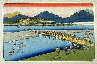
Warabi-shuku was the second of the sixty-nine stations of the Nakasendō highway connecting Edo with Kyoto during the Edo period. It was located in the present-day city of Warabi, Saitama Prefecture, Japan.

Wada-shuku

Wada-shuku was the twenty-eighth of the sixty-nine stations of the Nakasendō highway connecting Edo with Kyoto during the Edo period. It was located in the present-day town of Nagawa, in the Chiisagata District of Nagano Prefecture, Japan.

Nagakubo-shuku

Nagakubo-shuku was the twenty-seventh of the sixty-nine stations of the Nakasendō highway connecting Edo with Kyoto during the Edo period. It is located in the present-day town of Nagawa, in the Chiisagata District of Nagano Prefecture, Japan.

Shionada-shuku

Shionada-shuku was the twenty-third of the sixty-nine stations of the Nakasendō. It is located in the present-day city of Saku, in Nagano Prefecture, Japan.

Iwamurada-shuku

Iwamurada-shuku was the twenty-second of the sixty-nine stations of the Nakasendō. It is located in the present-day city of Saku, in Nagano Prefecture, Japan.

Kumagai-shuku

Kumagai-shuku was the eighth of the sixty-nine stations of the Nakasendō highway connecting Edo with Kyoto during the Edo period. It was located in the present-day city of Kuamagaya, Saitama Prefecture, Japan.

Oiwake-shuku

Oiwake-shuku was the twentieth of the sixty-nine stations of the Nakasendō. It is located in the present-day town of Karuizawa, in the Kitasaku District of Nagano Prefecture, Japan.

Kutsukake-shuku

Kutsukake-shuku was the nineteenth of the sixty-nine stations of the Nakasendō. It is located in the present-day town of Karuizawa, in the Kitasaku District of Nagano Prefecture, Japan.

Fukaya-shuku

Fukaya-shuku was the ninth of the sixty-nine stations of the Nakasendō highway connecting Edo with Kyoto during the Edo period It was located in the present-day city of Fukaya, Saitama Prefecture, Japan.

Honjō-shuku

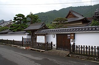
Honjō-shuku was the tenth of the sixty-nine stations of the Nakasendō highway connecting Edo with Kyoto during the Edo period. It was the largest of the stations in terms of population and number of buildings. It was located in the present-day city of Honjō, Saitama Prefecture, Japan.

Okegawa-shuku

Okegawa-shuku was the sixth of the sixty-nine stations of the Nakasendō highway connecting Edo with Kyoto during the Edo period. It was located in the present-day city of Okegawa, Saitama Prefecture, Japan.

Kōnosu-shuku

Kōnosu-shuku was the seventh of the sixty-nine stations of the Nakasendō highway connecting Edo with Kyoto during the Edo period. It was located in the present-day city of Kōnosu, Saitama Prefecture, Japan.

Sakamoto-shuku

Sakamoto-shuku was the seventeenth of the sixty-nine stations of the Nakasendō. It is located in the present-day city of Annaka, Gunma Prefecture, Japan.

Fujisawa-shuku

Fujisawa-shuku was the sixth of the fifty-three stations of the Tōkaidō. It is located in the present-day city of Fujisawa, Kanagawa Prefecture, Japan.

<i>The Sixty-nine Stations of the Kiso Kaidō</i>

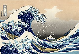
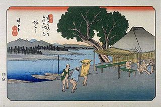
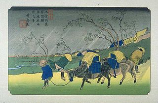
The Sixty-nine Stations of the Kiso Kaidō or Sixty-nine Stations of the Kiso Road, is a series of ukiyo-e works created by Utagawa Hiroshige and Keisai Eisen. There are 71 total prints in the series. The common name for the Kiso Kaidō is "Nakasendō," so this series is sometimes referred to as the Sixty-nine Stations of the Nakasendō. It is a follow up to Hiroshige's The Fifty-three Stations of the Tōkaidō and he produced 47 of the prints, with Eisen being responsible for the rest.

Yoshida-juku

Yoshida-juku was the thirty-fourth of the fifty-three stations of the Tōkaidō. It is located in the center of what is now the city of Toyohashi, Aichi Prefecture, Japan. It was 287 kilometres (178 mi) from the start of the route in Edo's Nihonbashi and 6.1 kilometres (3.8 mi) from Futagawa-juku to the east and 10.5 kilometres (6.5 mi) from Goyu-shuku to the west.

References

  1. Yama to Keikoku Publishing (2006). Nakasendō o Aruku (Revised ed.). Osaka: Yama to Keikoku Publishing. ISBN   4-635-60037-8.

Coordinates: 36°21′31″N138°38′08″E / 36.3586°N 138.6355°E / 36.3586; 138.6355

Geographic coordinate system Coordinate system

A geographic coordinate system is a coordinate system that enables every location on Earth to be specified by a set of numbers, letters or symbols. The coordinates are often chosen such that one of the numbers represents a vertical position and two or three of the numbers represent a horizontal position; alternatively, a geographic position may be expressed in a combined three-dimensional Cartesian vector. A common choice of coordinates is latitude, longitude and elevation. To specify a location on a plane requires a map projection.