
The Worshipful Company of Goldsmiths is one of the Great Twelve Livery Companies of the City of London. The company's headquarters are at Goldsmiths' Hall in the City of London.
O'Bannon is a neighborhood of Louisville, Kentucky centered along Old LaGrange Road and Collins Lane. O'Bannon was originally called Williamson after its first postmaster John Williamson, but was renamed in 1859 after postmaster John O'Bannon. The Post Office was located at the southwest corner of Old LaGrange Road and Collins Lane. O'Bannon Elementary School, which was located on Factory Lane, closed in 1960.

Zalamea la Real is a town and municipality located in the province of Huelva, Spain. According to the 2005 census, it had a population of 3547 inhabitants and covers a 240km² area(14.8 people/km²). It sits at an altitude of 412m above sea level, and is 67km from the capital.

The River Dunsop is a river in the Forest of Bowland in Northern England. It flows into the River Hodder at Dunsop Bridge.
Musgrave railway station was a railway station situated on the Eden Valley Railway and located between Penrith and Kirkby Stephen East, England.
The Church of the Annunciation is located at 3547 Clifton Avenue at Resor Street in Cincinnati, Ohio, United States. The Church is located in the Clifton neighborhood. It is part of the Clifton Avenue Historic District. This historic parish was founded, in February 1910, the present church was completed in August 1930. This church was designed by Boston architect Edward T. P. Graham, who was active in both the Archdiocese of Boston and the Archdiocese of Cincinnati in the first half of the 20th century.
The Lujanian age is a period of geologic time within the Pleistocene and Holocene epochs of the Neogene used more specifically with South American Land Mammal Ages. It follows the Ensenadan. The age is usually divided into the middle Pleistocene Bonaerian stage, which ends at about 130,000 years, and the Lujanian, which lasts from about 130,000 years into the early Holocene.

Mỹ Hội Đông is a rural commune (xã) and village of the Chợ Mới District of An Giang Province, Vietnam.

The John S. Knight Center is a large convocation center located in Akron, Ohio, named after the newspaper publisher and editor John S. Knight.

Písek is a village and municipality in Hradec Králové District in the Hradec Králové Region of the Czech Republic.

Maravilhas is a municipality in the state of Minas Gerais in the Southeast region of Brazil.
Campinápolis is a municipality in the state of Mato Grosso in the Central-West Region of Brazil.
Region 4 is the name of a Statistics Canada census division, one of six in the Northwest Territories, Canada. It was introduced in the 2011 census, along with Regions 1, 2, 3, 5, and 6, resulting in the abolition of the former census divisions of Fort Smith Region and Inuvik Region.

Fox Cave is located on East Highway 70 between Roswell and Alamogordo, near Ruidoso, New Mexico. It was once used as a hideout by William H. Bonney, better known as Billy the Kid and also known as Henry Antrim, a 19th-century American gunman who participated in the Lincoln County War and became a frontier outlaw in the American Old West.

Shkëmbi i Kavajës is a landmark named after the town of Kavajë, Albania. The outsized rock is about 6 kilometers from Kavajë and about 8 kilometers from Durrës. It is said to be the place where, in 48 BC, during Caesar's Civil War, Caesar fought against Pompey.
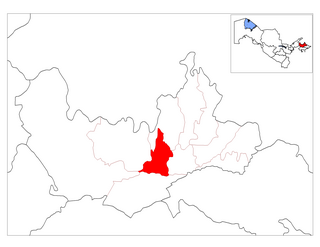
Turakurgan is a raion (district) of Namangan Region in Uzbekistan. The capital lies at Turakurgan.
Barrios Unidos is a corregimiento in Aguadulce District, Coclé Province, Panama. It has a land area of 64.5 square kilometres (24.9 sq mi) and had a population of 9,390 as of 2010, giving it a population density of 145.5 inhabitants per square kilometre (377/sq mi). It was created by Law 58 of July 29, 1998, owing to the Declaration of Unconstitutionality of Law 1 of 1982. Its population as of 2000 was 8,610.
Pipariya railway station is a railway station serving Pipariya town, in Hoshangabad district of Madhya Pradesh State of India. It is under Jabalpur railway division of West Central Railway Zone of Indian Railways. It is located on Katni-Satna main line of the Indian Railways.
The Natomas East Main Drainage Canal, formerly known as Steelhead Creek, flows into the American River in Sacramento County, California.

The Swan with Two Necks was a coaching inn in the City of London that, until the arrival of the railways, was one of the principal departure points for travel to the north of England from London. Its site was given over in the early 1860s to a goods and parcels depot for a firm of railway agents and carriers.


