Padua, Illinois | |
|---|---|
 Padua  Padua | |
| Coordinates: 40°27′01″N88°45′50″W / 40.45028°N 88.76389°W | |
| Country | United States |
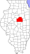
| State | Illinois |
| County | McLean |
| Elevation | 840 ft (260 m) |
| Time zone | UTC-6 (Central (CST)) |
| • Summer (DST) | UTC-5 (CDT) |
| Area code | 309 |
| GNIS feature ID | 415295 [1] |
Padua is a small unincorporated community in McLean County, Illinois, in the United States, with a population of about 525. Locals pronounce Padua as "pad-joo-way", rather than the traditional Italian pronunciation. [1] [2]