Twin Grove, Illinois | |
|---|---|
 Twin Grove  Twin Grove | |
| Coordinates: 40°29′36″N89°04′47″W / 40.49333°N 89.07972°W | |
| Country | United States |
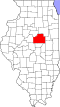
| State | Illinois |
| County | McLean |
| Townships | Dale, Dry Grove |
| Area | |
• Total | 3.97 sq mi (10.29 km2) |
| • Land | 3.96 sq mi (10.27 km2) |
| • Water | 0.01 sq mi (0.02 km2) |
| Elevation | 817 ft (249 m) |
| Population | |
• Total | 1,524 |
| • Density | 384.46/sq mi (148.46/km2) |
| Time zone | UTC-6 (Central (CST)) |
| • Summer (DST) | UTC-5 (CDT) |
| ZIP Code | 61705 (Bloomington) |
| Area code | 309 |
| GNIS feature ID | 2628561 [2] |
| FIPS code | 17-76511 |
Twin Grove is an unincorporated community and census-designated place (CDP) in McLean County, Illinois, United States. As of the 2020 census, Twin Grove had a population of 1,524. [3]