Paoli, Colorado | |
|---|---|
 Entering Paoli from the west on U.S. Route 6 (2013) | |
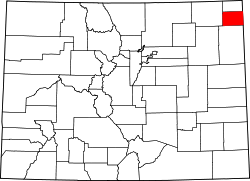
 Location within Phillips County and Colorado | |
| Coordinates: 40°36′44″N102°28′22″W / 40.61222°N 102.47278°W [1] | |
| Country | United States |
| State | Colorado |
| County | Phillips [2] |
| Incorporated | August 6, 1930 [3] |
| Named after | Pasquale Paoli |
| Area | |
• Total | 0.30 sq mi (0.77 km2) |
| • Land | 0.30 sq mi (0.77 km2) |
| • Water | 0.00 sq mi (0.00 km2) |
| Elevation | 3,895 ft (1,187 m) |
| Population | |
• Total | 51 |
| • Density | 170/sq mi (66/km2) |
| Time zone | UTC−7 (MST) |
| • Summer (DST) | UTC−6 (MDT) |
| ZIP Code | |
| Area code | 970 |
| FIPS code | 08-57245 [1] |
| GNIS ID | 182821 [1] |
Paoli is a statutory town in Phillips County, Colorado, United States. [1] As of the 2020 census, its population was 51. [5]