
Mount Vernon is a neighborhood of Baltimore, Maryland, located immediately north of the city's downtown district. Designated a city Cultural District, it is one of the oldest neighborhoods originally home to the city's wealthiest and most fashionable families. The name derives from Mount Vernon, the home of George Washington, given the original Washington Monument, a massive pillar commenced in 1815 to commemorate the first president of the United States, is the defining feature of the neighborhood.
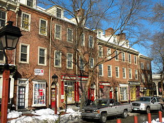
Society Hill is a historic neighborhood in Center City Philadelphia, with a population of 6,215 as of the 2010 United States Census. Settled in the early 1680s, Society Hill is one of the oldest residential neighborhoods in Philadelphia. After urban decay developed between the late 19th and early 20th centuries, an urban renewal program began in the 1950s, restoring the area and its many historic buildings. Society Hill has since become one of the most expensive neighborhoods with the highest average income and second-highest real estate values in Philadelphia. Society Hill's historic colonial architecture, along with planning and restoration efforts, led the American Planning Association to designate it, in 2008, as one of the great American neighborhoods and a good example of sustainable urban living.

The West Newton Village Center Historic District encompasses the heart of the village of West Newton, in the city of Newton, Massachusetts in the United States. It extends along Washington Street between Lucas Court in the west and Davis Court in the east, and includes a few properties on immediately adjacent side streets, including Watertown Street and Waltham Street. The village is the second-largest of Newton's commercial centers and is the best-preserved of its late 19th and early 20th century village centers. The district was listed on the National Register of Historic Places in 1990.

The Newtonville Historic District is a historic district in the village of Newtonville, in Newton, Massachusetts. The district encompasses the southern portion of the village's business district, as well as surrounding residential areas. It was listed on the National Register of Historic Places in 1986, and enlarged in 1990.
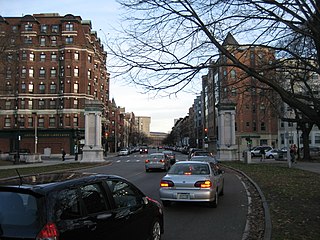
The Fenway-Boylston Street District is a historic district encompassing a series of predominantly residential buildings lining The Fenway in the Fenway–Kenmore of Boston, Massachusetts. Developed beginning in the 1890s, the area is emblematic of Boston's upper-class residential development of the period, with architect-designed houses built for some of the city's leading families. The district was listed on the National Register of Historic Places in 1984.

Bellingham Square Historic District is a historic district encompassing the civic and commercial heart of Chelsea, Massachusetts. Roughly bounded by Broadway, Shawmut, Chestnut, and Shurtleff Streets, the district was almost entirely built in the aftermath of the Great Chelsea Fire of 1908, and is a monument to the civic planning that took place at the time. The district was added to the National Register of Historic Places in 1985.

The Franklin Common Historic District is a historic district encompassing the traditional village center of Franklin, Massachusetts. The primary focus of the district is the town common, a roughly triangular green which took shape in the mid-18th century. The district includes the buildings that abut the green, and extends northward along Main Street to its junction with Lincoln Street, where the Red Brick School is located. The Dean Junior College Historic District abuts this district to the south. The district is predominantly residential in character, with several civic and religious institutional buildings facing the common. The latter group are dominated by the Federated Church, and the Roman Catholic St. Mary's Church complex, which includes three buildings from the 1920s to 1955.

The Main Street Historic District encompasses the civic core of Greenfield, Massachusetts, the county seat of Franklin County, Massachusetts. The district includes several blocks of Main Street extending roughly from Chapman Street in the west to Franklin Street in the east, as well as a number of properties facing the common along Bank Row, south of Main Street, and is architecture reflective of the city's 19th-century growth as a major crossroads and county seat. The district includes the town hall, county courthouse, several 19th century bank buildings, and three properties previously listed on the National Register of Historic Places: the Garden Theater Block, the Leavitt-Hovey House, and the 1915 Post Office building. The district was listed on the National Register of Historic Places in 1988.

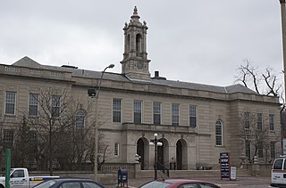
Peabody City Hall is the historic city hall of Peabody, Massachusetts. It is located at 24 Lowell Street, near Peabody Square.

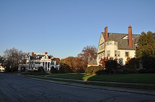
The Washington Street Historic District encompasses a fashionable 19th-century residential area near downtown Peabody, Massachusetts. It extends along Washington, Holten, and Sewall Streets, and is where business and civic leaders of the community built their homes. The district was added to the National Register of Historic Places in 1985.
The Arlington Center Historic District includes the civic and commercial heart of Arlington, Massachusetts. It runs along the town's main commercial district, Massachusetts Avenue, from Jason Street to Franklin Street, and includes adjacent 19th- and early 20th-century residential areas roughly bounded by Jason Street, Pleasant Street, and Gray Street. The district was listed on the National Register of Historic Places in 1974.
The Belvidere Hill Historic District encompasses a residential area on the east side of Lowell, Massachusetts known for its fine 19th-century houses. The area, roughly bounded by Wyman, Belmont, Fairview, and Nesmith Streets, was developed beginning in the 1850s, and was one of the finest neighborhoods in the city, home to many of its business and civic leaders. It was listed on the National Register of Historic Places in 1995.

The Nobility Hill Historic District is a residential historic district roughly bounded by Chestnut and Maple Streets and Cedar Avenue in Stoneham, Massachusetts. The district includes a number of high quality houses representing a cross section of fashionable housing built between 1860 and 1920. It was added to the National Register of Historic Places in 1990.

The Brookline Town Green Historic District encompasses the historic colonial heart of the town of Brookline, Massachusetts. Centered on a stretch of Walnut Street between Warren and Chestnut Streets, this area is where the town's first colonial meeting house and cemetery were laid out, and was its center of civic life until the early 19th century. The district was listed on the National Register of Historic Places in 1980.

The Front Street Historic District in Exeter, New Hampshire, encompasses a portion of the town's historic center. The district extends from Swasey Pavilion, at the junction of Front and Water streets, southwesterly along Front Street to Gale Park, about five blocks. Front Street is one of Exeter's oldest roads, and is lined with a series of 18th and 19th-century civic, religious, and residential structures, many of which are well preserved. The district was listed on the National Register of Historic Places (NRHP) in 1973.

The Gateway Mall in St. Louis, Missouri is an open green space running linearly, one block wide, from the Gateway Arch at Memorial Drive to Union Station at 20th Street. Located in the city's downtown, it runs between Market Street and Chestnut Street.

The Exeter Waterfront Commercial Historic District encompasses the historic commercial and residential waterfront areas of Exeter, New Hampshire. The district extends along the north side of Water Street, roughly from Main Street to Front Street, and then along both sides of Water and High streets to the latter's junction with Portsmouth Street. It also includes properties on Chestnut Street on the north side of the Squamscott River. This area was where the early settlement of Exeter took place in 1638, and soon developed as a shipbuilding center. The district was listed on the National Register of Historic Places in 1980. It was enlarged in 1986 to include the mill complex of the Exeter Manufacturing Company on Chestnut Street.

The Town Center Historic District encompasses the historic village center of South Hampton, New Hampshire. Centered around the Barnard Green, the town common, on New Hampshire Route 107A, it includes architectural reminders of the town's growth and change over time. The district was listed on the National Register of Historic Places in 1983.

The St. Johnsbury Main Street Historic District encompasses the historic civic and cultural center of the town of St. Johnsbury, Vermont. Organized along the town's Main Street, it includes high-quality architecture spanning the 19th and early 20th centuries, and includes the National Historic Landmark St. Johnsbury Athenaeum. Many of the district's buildings were designed by Lambert Packard, a prominent local architect. The district was listed on the National Register of Historic Places in 1975, and was enlarged slightly in 1976. It was subsumed into the larger St. Johnsbury Historic District in 1980.
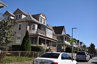
The Esmond Street Historic District is a historic district encompassing a small residential area in the Dorchester neighborhood of Boston, Massachusetts. Centered on a stretch of Esmond Street, the area was developed between 1884 and 1928, and includes a fine sample of Colonial Revival and Queen Anne architecture. The district was listed on the National Register of Historic Places in 2018.


