Pendergrass, Georgia

Last updated

Pendergrass, Georgia
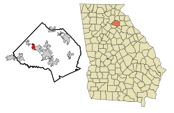
Jackson County Georgia Incorporated and Unincorporated areas Pendergrass Highlighted.svg
Location in Jackson County and the state of Georgia
Coordinates: 34°9′51″N83°40′52″W / 34.16417°N 83.68111°W / 34.16417; -83.68111
Country United States
State Georgia
County Jackson
Area
[1]
  Total3.43 sq mi (8.88 km2)
  Land3.38 sq mi (8.76 km2)
  Water0.04 sq mi (0.12 km2)
Elevation
863 ft (263 m)
Population
 (2020)
  Total1,692
  Density500.15/sq mi (193.10/km2)
Time zone UTC-5 (Eastern (EST))
  Summer (DST) UTC-4 (EDT)
ZIP code
30567
Area code 706
FIPS code 13-60032 [2]
GNIS feature ID0320353 [3]
Website cityofpendergrass.com

Pendergrass is a city in Jackson County, Georgia, United States. The population was 1692 at the time of the 2020 census. [4]

Contents

History

The town was chartered by an act of the Georgia Legislature on December 30, 1890. [5] The community was named after J. B. Pendergrass, a local physician. [6]

Geography

Pendergrass is located in northwestern Jackson County at 34°9′51″N83°40′52″W / 34.16417°N 83.68111°W / 34.16417; -83.68111 (34.164223, -83.681047). [7]

It is bordered to the southeast by Jefferson, the county seat, and to the northwest by Talmo. U.S. Route 129 passes through the northeast side of the city, leading northwest 14 miles (23 km) to Gainesville and southeast through Jefferson 24 miles (39 km) to Athens.

According to the United States Census Bureau, Pendergrass has a total area of 3.1 square miles (7.9 km2), of which 0.04 square miles (0.1 km2), or 1.48%, are water. [4] The city is part of the Middle Oconee River watershed.

Demographics

Historical population
CensusPop.Note
1900 232
1910 2393.0%
1920 27715.9%
1930 224−19.1%
1940 189−15.6%
1950 1890.0%
1960 21513.8%
1970 26724.2%
1980 30213.1%
1990 298−1.3%
2000 43144.6%
2010 422−2.1%
2020 1,692300.9%
U.S. Decennial Census [8]

As of the census [2] of 2000, there were 431 people, 156 households, and 117 families residing in the city. The population density was 212.8 inhabitants per square mile (82.2/km2). There were 171 housing units at an average density of 84.4 per square mile (32.6/km2). The racial makeup of the city was 98.14% White, 0.93% Native American, 0.46% from other races, and 0.46% from two or more races. Hispanic or Latino of any race were 4.18% of the population.

There were 156 households, out of which 30.8% had children under the age of 18 living with them, 57.1% were married couples living together, 11.5% had a female householder with no husband present, and 25.0% were non-families. 17.9% of all households were made up of individuals, and 8.3% had someone living alone who was 65 years of age or older. The average household size was 2.76 and the average family size was 3.12.

In the city, the population was spread out, with 26.7% under the age of 18, 8.8% from 18 to 24, 28.3% from 25 to 44, 24.6% from 45 to 64, and 11.6% who were 65 years of age or older. The median age was 33 years. For every 100 females, there were 99.5 males. For every 100 females age 18 and over, there were 93.9 males.

The median income for a household in the city was $33,751, and the median income for a family was $37,700. Males had a median income of $23,750 versus $15,179 for females. The per capita income for the city was $11,699. About 9.3% of families and 15.9% of the population were below the poverty line, including 19.3% of those under age 18 and 10.5% of those age 65 or over.

The Pendergrass library currently houses a history book of the area and the Pendergrass family.

Economy

Related Research Articles

<span class="mw-page-title-main">White County, Georgia</span> County in Georgia, United States

White County is a county located in the northeastern part of the U.S. state of Georgia. As of the 2020 census, the population was 28,003. The county seat is Cleveland. The county was created on December 22, 1857, formerly a part of Habersham County and most likely was named for Newton County Representative David T. White, who helped a Habersham representative successfully attain passage of an act creating the new county.

<span class="mw-page-title-main">Banks County, Georgia</span> County in Georgia, United States

Banks County is a county located in the northeastern part of the U.S. state of Georgia. As of the 2020 census, the population was 18,035, down from 18,395 in 2010. The county seat is Homer. The Old Banks County Courthouse is located in Homer and listed on the National Register of Historic Places. A new county courthouse was constructed adjacent to the old one in 1983.

<span class="mw-page-title-main">Greers Ferry, Arkansas</span> City in Arkansas, United States

Greers Ferry is a city in Cleburne County, Arkansas, United States. The population was 891 at the 2010 census. It was founded in 1968.

<span class="mw-page-title-main">Lilly, Georgia</span> City in Georgia, United States

Lilly is a city in Dooly County, Georgia, United States. The population was 213 at the 2010 census.

<span class="mw-page-title-main">Bowman, Georgia</span> City in Georgia, United States

Bowman is a city in Elbert County, Georgia, United States. As of the 2020 census, the city had a population of 872.

<span class="mw-page-title-main">Canon, Georgia</span> City in Georgia, United States

Canon is a city in Franklin and Hart counties in the U.S. state of Georgia. The population was 804 at the 2010 census.

<span class="mw-page-title-main">Franklin Springs, Georgia</span> City in Georgia, United States

Franklin Springs is a city in Franklin County, Georgia, United States. The population was 952 at the 2010 census, up from 762 in 2000. Emmanuel University is located here.

<span class="mw-page-title-main">Royston, Georgia</span> City in Georgia, United States

Royston is a city in Franklin, Hart, and Madison counties in the U.S. state of Georgia. The population was 2,649 at the 2020 census.

<span class="mw-page-title-main">Bowersville, Georgia</span> Town in Georgia, United States

Bowersville is a town in Hart County, Georgia, United States. As of the 2020 census, the town had a population of 444.

<span class="mw-page-title-main">Arcade, Georgia</span> City in Georgia, United States

Arcade is a city in Jackson County, Georgia, United States. As of the 2020 census it had a population of 1,884.

<span class="mw-page-title-main">Hoschton, Georgia</span> City in Georgia, United States

Hoschton is a city in Jackson County, Georgia, United States. The population was 1,377 at the 2010 census. As of 2018 the estimated population was 1,916.

<span class="mw-page-title-main">Talmo, Georgia</span> Town in Georgia, United States

Talmo is a town in Jackson County, Georgia, United States. The population was 257 at the 2020 census.

<span class="mw-page-title-main">Colbert, Georgia</span> City in Georgia, United States

Colbert is a city in Madison County, Georgia, United States. The population was 630 at the 2020 census.

<span class="mw-page-title-main">Hull, Georgia</span> City in Georgia, United States

Hull is a city in Madison County, Georgia, United States. The population was 230 at the 2020 census, up from 198 in 2010.

<span class="mw-page-title-main">Ila, Georgia</span> City in Georgia, United States

Ila is a city in Madison County, Georgia, United States. The population was 350 at the 2020 census.

<span class="mw-page-title-main">LaFayette, Georgia</span> City in Georgia, United States

LaFayette is a city in, and the county seat of, Walker County, Georgia, United States. As of the 2020 census, the city population was 6,888. It was founded as Chattooga.

<span class="mw-page-title-main">Middle River, Minnesota</span> City in Minnesota, United States

Middle River is a city in Marshall County, Minnesota, United States, along the Middle River, from which the city took its name. The population was 304 at the 2020 census.

<span class="mw-page-title-main">Stowe, Pennsylvania</span> Census-designated place in Pennsylvania, United States

Stowe is a census-designated place (CDP) in West Pottsgrove Township, Montgomery County, Pennsylvania, United States. The population was 3,695 at the 2010 census. It uses the Pottstown ZIP code of 19464.

<span class="mw-page-title-main">Warren South, Pennsylvania</span> Census-designated place in Pennsylvania, United States

Warren South is a former census-designated place (CDP) in Warren County, Pennsylvania, United States. The population was 1,651 at the 2000 census.

<span class="mw-page-title-main">Pine Grove, West Virginia</span> Town in West Virginia, United States

Pine Grove is a town in Wetzel County, West Virginia, United States. The population was 363 at the 2020 census. The community was named for a grove of pine trees near the original town site.

References

  1. "2020 U.S. Gazetteer Files". United States Census Bureau. Retrieved December 18, 2021.
  2. 1 2 "U.S. Census website". United States Census Bureau . Retrieved January 31, 2008.
  3. "US Board on Geographic Names". United States Geological Survey. October 25, 2007. Retrieved January 31, 2008.
  4. 1 2 "Geographic Identifiers: 2010 Census Summary File 1 (G001): Pendergrass town, Georgia". American Factfinder. U.S. Census Bureau. Archived from the original on February 13, 2020. Retrieved May 3, 2018.
  5. Eller, Austin (February 2, 2021). "Jackson County representative introduces bill to abolish Pendergrass". accesswdun.com. Retrieved February 4, 2021.
  6. Krakow, Kenneth K. (1975). Georgia Place-Names: Their History and Origins (PDF). Macon, GA: Winship Press. p. 173. ISBN   0-915430-00-2.
  7. "US Gazetteer files: 2010, 2000, and 1990". United States Census Bureau. February 12, 2011. Retrieved April 23, 2011.
  8. "Census of Population and Housing". Census.gov. Retrieved June 4, 2015.