Penn Township, Huntingdon County, Pennsylvania

Last updated

Penn Township,
Huntingdon County,
Pennsylvania
Brumbaugh Homestead east and north.jpg
Ruins of the Brumbaugh Homestead, a historic site in the township
Map of Huntingdon County, Pennsylvania Highlighting Penn Township.PNG
Map of Huntingdon County, Pennsylvania Highlighting Penn Township
Map of Pennsylvania highlighting Huntingdon County.svg
Map of Huntingdon County, Pennsylvania
Country United States
State Pennsylvania
County Huntingdon
Area
[1]
  Total34.57 sq mi (89.53 km2)
  Land28.62 sq mi (74.13 km2)
  Water5.95 sq mi (15.41 km2)
Population
 (2020) [2]
  Total1,078 Increase2.svg
  Estimate 
(2022) [2]
1,062
  Density38.01/sq mi (14.68/km2)
Time zone UTC-5 (Eastern (EST))
  Summer (DST) UTC-4 (EDT)
Zip code
16647, 16657
Area code 814
FIPS code 42-061-58832
Local phone exchanges: 658

Penn Township is a township in Huntingdon County, Pennsylvania, United States. The population was 1,078 at the 2020 census. [2] The township includes the village of Hesston and the Seven Points Marina of Raystown Lake.

Contents

History

'The Proprietaries of the Pennsylvania province, mindful of the rights of the natives and anxious to promote peace with them, would not grant land nor permit settlements to be made until the Indian title had been purchased. At a treaty held at Albany on the 6th day of July 1754, the Six Nations, consisting of the Mohawks, Oneidas, Onondagas, Cayugas, Senecas and Tuscaroras, executed a deed to the Proprietaries for a large portion of the territory of the province including the whole of the valley of the Juniata [then Harrisburg to Pittsburgh]. Soon after this event the resident tribes sought a home elsewhere.’ [3]

According to various family histories—the white settlers first inhabited the Woodcock Valley Manor [4] during the American Revolutionary War and as early as 1772. [5] For the first time the families of Northern Europeans [German, English, Irish & Welsh] lived in freedom and worshiped the religion of their choice. The early Colonist cleared the virgin forests and carved farms out the land—and these are the same working farms that you see today. [6]

'In the early 1800s individuals of the area began mining Tussey Mountain for ore. These men operated on a small scale, but later larger companies started operations. One of these was the Grove Brothers of Danville, Montour Co., PA. They hauled ore to Cambria Iron Ore Works at Johnstown.' [7]

Penn Township was officially made from part of Hopewell Township on November 21, 1846.

The ore was processed into Juniata pig iron and sent away from the area to be manufactured into tools, machinery, steam engines, and the first railroads. [8]

‘On May 6, 1852, the Huntingdon and Broad Top Railroad and Coal Company was incorporated and on August 13, 1855, trains began running from Huntingdon to Bedford.’ [5] and through the villages of Penn Township.

In 1885—‘Robert Hare Powel & Company built a track from their quarries out from Grafton [Hesston] to the line of the Huntingdon & Broad Top railroad, one-half mile south of the station for the purpose of shipping limestone to their furnace at Saxton.’ [9]

‘The first telephone company entirely located within Penn Township was called the Raystown Branch Telephone Company. It was commonly called the ‘Buttermilk line’. Having thirty six subscribers. Poles and wire were maintained by them. The line had one wire and used the earth as the second, a ground wire.’(1896) [10]

'In the early 1900s the Colonial Iron Company of Riddlesburg, purchased the Grove Brothers operations. The mines continued in operation until before WWI when they closed down.' [11]

‘Penn Township was not completely electrified until 1947, which was when Valley Rural Electric Cooperative strung lines on the hills and valleys from Tussey Mountain to the Raystown Branch of the Juniata River. Holes were dug and poles set, all by hand.’ [12]

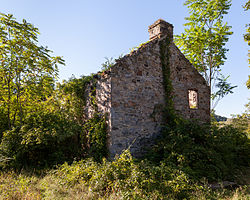
The Brumbaugh Homestead was listed on the National Register of Historic Places in 1979. [13]

Geography

According to the United States Census Bureau, the township has a total area of 34.3 square miles (88.8 km2), of which 28.2 square miles (73.1 km2) is land and 6.1 square miles (15.7 km2) (17.65%) is water.

Adjacent Municipalities

All municipalities listed are in Huntingdon County unless otherwise noted.

Demographics

Historical population
CensusPop.Note
2000 1,054
2010 1,0772.2%
2020 1,0780.1%
2022 (est.)1,062 [2] −1.5%
U.S. Decennial Census [14]

As of the census [15] of 2000, there were 1,054 people, 400 households, and 320 families residing in the township. The population density was 37.3 inhabitants per square mile (14.4/km2). There were 666 housing units at an average density of 23.6/sq mi (9.1/km2). The racial makeup of the township was 99.15% White, 0.09% African American, 0.57% from other races, and 0.19% from two or more races. Hispanic or Latino of any race were 0.95% of the population.

There were 400 households, out of which 33.8% had children under the age of 18 living with them, 68.0% were married couples living together, 7.8% had a female householder with no husband present, and 20.0% were non-families. 16.8% of all households were made up of individuals, and 5.5% had someone living alone who was 65 years of age or older. The average household size was 2.56 and the average family size was 2.87.

In the township the population was spread out, with 24.0% under the age of 18, 4.9% from 18 to 24, 29.9% from 25 to 44, 28.0% from 45 to 64, and 13.2% who were 65 years of age or older. The median age was 40 years. For every 100 females there were 105.9 males. For every 100 females age 18 and over, there were 98.8 males.

The median income for a household in the township was $41,210, and the median income for a family was $42,083. Males had a median income of $35,066 versus $22,614 for females. The per capita income for the township was $17,063. About 5.6% of families and 11.9% of the population were below the poverty line, including 15.3% of those under age 18 and 6.7% of those age 65 or over.

Recreation

A portion of Raystown Lake is located in Penn Township and a small portion of Pennsylvania State Game Lands Number 118 is located on the eastern slope of Tussey Mountain in the western part of the township. [16] [17]

Related Research Articles

<span class="mw-page-title-main">Bedford County, Pennsylvania</span> County in Pennsylvania, United States

Bedford County is a county in the Commonwealth of Pennsylvania. As of the 2020 census, the population was 47,577. The county seat is Bedford. The county is part of the Southwest Pennsylvania region of the state.

<span class="mw-page-title-main">Huntingdon County, Pennsylvania</span> County in Pennsylvania, United States

Huntingdon County is a county in the Commonwealth of Pennsylvania. As of the 2020 census, the population was 44,092. Its county seat is Huntingdon. The county was created on September 20, 1787, mainly from the northern part of Bedford County, plus an addition of territory on the east from Cumberland County. The county is part of the Southwest Pennsylvania region of the state.

<span class="mw-page-title-main">Blair County, Pennsylvania</span> County in Pennsylvania, United States

Blair County is a county in the Commonwealth of Pennsylvania. As of the 2020 census, the population was 122,822. Its county seat is Hollidaysburg, and its largest city is Altoona. The county was created on February 26, 1846, from parts of Huntingdon and Bedford counties. The county is part of the Southwest Pennsylvania region of the state.

<span class="mw-page-title-main">Hopewell, Bedford County, Pennsylvania</span> Borough in Pennsylvania, United States

Hopewell is a borough in Bedford County, Pennsylvania, United States. The population was 189 at the 2020 census.

<span class="mw-page-title-main">Hopewell Township, Bedford County, Pennsylvania</span> Township in Pennsylvania, United States

Hopewell Township is a township in Bedford County, Pennsylvania, United States. The population was 1,890 at the 2020 census.

<span class="mw-page-title-main">Saxton, Pennsylvania</span> Borough in Pennsylvania, United States

Saxton is a borough in Bedford County, Pennsylvania, United States. The population was 726 at the 2020 census.

<span class="mw-page-title-main">Snake Spring Township, Pennsylvania</span> Township in Pennsylvania, United States

Snake Spring Township is a township in Bedford County, Pennsylvania, United States. The population was 1,771 at the 2020 census.

<span class="mw-page-title-main">Catharine Township, Pennsylvania</span> Township in Pennsylvania, United States

Catharine Township is a township in Blair County, Pennsylvania, United States. The population was 773 at the 2020 census. It is part of the Altoona, PA Metropolitan Statistical Area.

<span class="mw-page-title-main">North Woodbury Township, Pennsylvania</span> Township in Pennsylvania, United States

North Woodbury Township is a township in Blair County, Pennsylvania, United States. It is part of the Altoona, PA Metropolitan Statistical Area. The population was 2,434 at the 2020 census.

<span class="mw-page-title-main">Woodbury Township, Blair County, Pennsylvania</span> Township in Pennsylvania, United States

Woodbury Township is a township in Blair County, Pennsylvania, United States. It is part of the Altoona, PA Metropolitan Statistical Area. The population was 1,438 at the 2020 census.

<span class="mw-page-title-main">Henderson Township, Huntingdon County, Pennsylvania</span> Township in Pennsylvania, United States

Henderson Township is a township which is located in Huntingdon County, Pennsylvania, United States. The population was 923 at the time of the 2020 census.

<span class="mw-page-title-main">Huntingdon, Pennsylvania</span> Borough in Pennsylvania, United States

Huntingdon is a borough in and county seat of Huntingdon County, Pennsylvania, United States. It is located along the Juniata River, approximately 32 miles (51 km) east of Altoona and 92 miles (148 km) west of Harrisburg. With a population of 6,827 at the 2020 census, it is the largest population center near Raystown Lake, a winding, 28-mile-long (45 km) flood-control reservoir managed by the U.S. Army Corps of Engineers.

<span class="mw-page-title-main">Mapleton, Pennsylvania</span> Borough in Pennsylvania, United States

Mapleton is a borough in Huntingdon County, Pennsylvania, United States. The population was 441 at the 2010 census. It is located on the Juniata River, which is a tributary of the Susquehanna River.

<span class="mw-page-title-main">Marklesburg, Pennsylvania</span> Borough in Pennsylvania, United States

Marklesburg is a borough in Huntingdon County, Pennsylvania, United States. The population was 204 at the 2010 census.

<span class="mw-page-title-main">Porter Township, Huntingdon County, Pennsylvania</span> Township in Pennsylvania, United States

Porter Township is a township that is located in Huntingdon County, Pennsylvania, United States. The population was 1,907 at the time of the 2020 census.

<span class="mw-page-title-main">Walker Township, Huntingdon County, Pennsylvania</span> Township in Pennsylvania, United States

Walker Township is a township in Huntingdon County, Pennsylvania, United States. The population was 1,969 at the time of the 2020 census.

<span class="mw-page-title-main">West Perry Township, Pennsylvania</span> Township in Pennsylvania, United States

West Perry Township is a township in Snyder County, Pennsylvania, United States. The population was 1,082 at the 2020 census.

<span class="mw-page-title-main">Pennsylvania Route 26</span> State highway in Pennsylvania, US

Pennsylvania Route 26 is a 125.5-mile (202.0 km) highway in the south-central area of Pennsylvania. Its northern terminus is at PA 150 northwest of Howard; its southern terminus is at the Maryland state line near Barnes Gap in Union Township. Two major destinations along this route are Raystown Lake near Huntingdon and the Pennsylvania State University at State College.

Hesston is an unincorporated community in Penn Township of Huntingdon County, Pennsylvania, United States. Also located in Hesston is Raystown Lake. Hesston is the home of the Hesston Speedway. The community was originally called Pleasant Grove and Grafton, but renamed Hesston.

The Pennsylvania State Game Lands Number 118 are Pennsylvania State Game Lands in Blair and Huntingdon counties in Pennsylvania in the United States, providing hunting, bird watching, and other activities.

References

  1. "2016 U.S. Gazetteer Files". United States Census Bureau. Retrieved August 14, 2017.
  2. 1 2 3 4 Bureau, US Census. "City and Town Population Totals: 2020-2022". Census.gov. US Census Bureau. Retrieved January 31, 2024.
  3. Mount Union Times (Mount Union, PA) September 3, 1909, Pg. 1 Col. 3 'Standing Stone'.
  4. Chronicles of Central Pennsylvania. V. 2. Godcharles, Fredric Antes, 1872-1944. Page 129. Online at Hathitrust
  5. 1 2 Huntingdon Daily News (Huntingdon, Pa.) July 22, 1981, Pg. 24 Col. 6.
  6. Municipal Histories 974.873-R 12 at Huntingdon Co. Historical Society, PA
  7. Marklesburg Centennial (1873-1973)[p.6 Industries]
  8. Bedford Inquirer (Bedford, Pa.) September 14, 1866, Pg. 3 Col. 2. ‘The Rolling Mill Project.’
  9. Huntingdon Globe (Huntingdon, Pa.) March 12, 1885, Pg. 3 Col. 1.
  10. Mapleton Item (Mapleton Depot, Pa.)December 9, 1896, Pg. 5 Col. 4.
  11. Ibid 7.
  12. Municipal Histories 974.873-R 12 Huntingdon County Historical Society, Pennsylvania
  13. "National Register Information System". National Register of Historic Places . National Park Service. July 9, 2010.
  14. "Census of Population and Housing". Census.gov. Retrieved June 4, 2016.
  15. "U.S. Census website". United States Census Bureau . Retrieved January 31, 2008.
  16. https://viewer.nationalmap.gov/advanced-viewer/ The National Map, retrieved November 12, 2018
  17. Pennsylvania State Game Lands Number 118, retrieved November 12, 2018

40°22′00″N78°04′59″W / 40.36667°N 78.08306°W / 40.36667; -78.08306