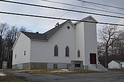
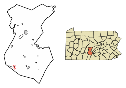
Broad Top City, Pennsylvania

Last updated
Broad Top City, Pennsylvania
Borough
Broad Top Church of Christ.jpg
Church of Christ on Railroad Avenue
Huntingdon County Pennsylvania Incorporated and Unincorporated areas Broad Top City Highlighted.svg
Location of Broad Top City in Huntingdon County, Pennsylvania.
USA Pennsylvania location map.svg
Red pog.svg
Broad Top City
Usa edcp location map.svg
Red pog.svg
Broad Top City
Coordinates: 40°12′06″N78°08′23″W / 40.20167°N 78.13972°W / 40.20167; -78.13972
Country United States
State Pennsylvania
County Huntingdon
Government
  TypeBorough Council
  MayorNathan Neville (R)
Area
[1]
  Total0.68 sq mi (1.75 km2)
  Land0.68 sq mi (1.75 km2)
  Water0.00 sq mi (0.00 km2)
Elevation
1,975 ft (602 m)
Population
 (2020) [2]
  Total367
  Density542.10/sq mi (209.38/km2)
Time zone UTC-5 (Eastern (EST))
  Summer (DST) UTC-4 (EDT)
ZIP code
16621
Area code 814
FIPS code 42-08896
Local phone exchanges: 635

Broad Top City is a borough in Huntingdon County, Pennsylvania, United States. The population was 371 at the 2020 census, [3] a decline from the figure of 452 tabulated in 2010. [4]

Contents

Geography

Broad Top City is located in southwestern Huntingdon County and is bordered to the north, west, and south by Carbon Township and to the east by Wood Township. The borough sits on top of a plateau at an elevation of 1,970 feet (600 m) above sea level.

Pennsylvania Route 913 passes through the center of the borough, leading west 2.5 miles (4.0 km) to Dudley and southeast 2 miles (3 km) to Robertsdale, downhill in both directions.

According to the United States Census Bureau, the borough has a total area of 0.68 square miles (1.75 km2), all land. [4]

Demographics

Historical population
CensusPop.Note
1870 327
1880 298−8.9%
1890 240−19.5%
1900 2587.5%
1910 47885.3%
1920 5198.6%
1930 511−1.5%
1940 61019.4%
1950 483−20.8%
1960 334−30.8%
1970 283−15.3%
1980 34020.1%
1990 331−2.6%
2000 38416.0%
2010 45217.7%
2020 371−17.9%
2021 (est.)367 [3] −1.1%
Sources: [5] [6] [7] [8] [2]

As of the census [6] of 2000, there were 384 people, 162 households, and 117 families residing in the borough. The population density was 600.8 inhabitants per square mile (232.0/km2). There were 178 housing units at an average density of 278.5 per square mile (107.5/km2). The racial makeup of the borough was 100.00% White.

There were 162 households, out of which 30.9% had children under the age of 18 living with them, 58.0% were married couples living together, 8.0% had a female householder with no husband present, and 27.2% were non-families. 24.7% of all households were made up of individuals, and 14.8% had someone living alone who was 65 years of age or older. The average household size was 2.37 and the average family size was 2.80.

In the borough the population was spread out, with 20.6% under the age of 18, 7.8% from 18 to 24, 24.2% from 25 to 44, 30.7% from 45 to 64, and 16.7% who were 65 years of age or older. The median age was 43 years. For every 100 females there were 106.5 males. For every 100 females age 18 and over, there were 100.7 males.

The median income for a household in the borough was $27,500, and the median income for a family was $33,056. Males had a median income of $28,438 versus $21,250 for females. The per capita income for the borough was $12,788. About 21.2% of families and 19.8% of the population were below the poverty line, including 19.8% of those under age 18 and 3.6% of those age 65 or over.

Related Research Articles

<span class="mw-page-title-main">Broad Top Township, Pennsylvania</span> Township in Pennsylvania, United States

Broad Top Township is a township in Bedford County, Pennsylvania, United States. The population was 1,441 at the 2020 census.

<span class="mw-page-title-main">Hopewell, Bedford County, Pennsylvania</span> Borough in Pennsylvania, United States

Hopewell is a borough in Bedford County, Pennsylvania, United States. The population was 189 at the 2020 census.

<span class="mw-page-title-main">Saxton, Pennsylvania</span> Borough in Pennsylvania, United States

Saxton is a borough in Bedford County, Pennsylvania, United States. The population was 726 at the 2020 census.

<span class="mw-page-title-main">Cassville, Pennsylvania</span> Borough in Pennsylvania, United States

Cassville is a borough in Huntingdon County, Pennsylvania, United States. As of the 2020 census, the borough population was 138.

<span class="mw-page-title-main">Coalmont, Pennsylvania</span> Borough in Pennsylvania, United States

Coalmont is a borough in Huntingdon County, Pennsylvania, United States. The population was 91 at the 2020 census.

<span class="mw-page-title-main">Dudley, Pennsylvania</span> Borough in Pennsylvania, United States

Dudley is a borough in Huntingdon County, Pennsylvania, United States. The population was 185 at the 2020 census.

<span class="mw-page-title-main">Mapleton, Pennsylvania</span> Borough in Pennsylvania, United States

Mapleton is a borough in Huntingdon County, Pennsylvania, United States. The population was 441 at the 2010 census. It is located on the Juniata River, which is a tributary of the Susquehanna River.

<span class="mw-page-title-main">Marklesburg, Pennsylvania</span> Borough in Pennsylvania, United States

Marklesburg is a borough in Huntingdon County, Pennsylvania, United States. The population was 204 at the 2010 census.

<span class="mw-page-title-main">Mill Creek, Pennsylvania</span> Borough in Pennsylvania, United States

Mill Creek is a borough in Huntingdon County, Pennsylvania, United States. The population was 328 at the 2010 census.

<span class="mw-page-title-main">Mount Union, Pennsylvania</span> Borough in Pennsylvania, United States

Mount Union is a borough in Huntingdon County, Pennsylvania, United States, approximately 44 miles (71 km) southeast of Altoona and 12 miles (19 km) southeast of Huntingdon, on the Juniata River. In the vicinity are found bituminous coal, ganister rock, fire clay, and some timber. A major Easter grass factory is located in the northern quadrant of the borough limits; until May 2007, the facility was owned by Bleyer Industries. The population was 2,447 at the 2010 census.

<span class="mw-page-title-main">Orbisonia, Pennsylvania</span> Borough in Pennsylvania, United States

Orbisonia is a borough in Huntingdon County, Pennsylvania, United States. The population was 428 at the 2010 census.

<span class="mw-page-title-main">Petersburg, Pennsylvania</span> Borough in Pennsylvania, United States

Petersburg is a borough in Huntingdon County, Pennsylvania, United States. It was a stop on the former Pennsylvania Railroad Main Line between Tyrone and Huntingdon and the junction point for the Petersburg Branch. The population was 480 at the 2010 census.

<span class="mw-page-title-main">Rockhill, Pennsylvania</span> Borough in Pennsylvania, United States

Rockhill or Rockhill Furnace is a borough in Huntingdon County, Pennsylvania, United States. The population was 371 at the 2010 census, down from 414 at the 2000 census. It is the site of the East Broad Top Railroad and the Rockhill Trolley Museum.

<span class="mw-page-title-main">Saltillo, Pennsylvania</span> Borough in Pennsylvania, United States

Saltillo is a borough in Huntingdon County, Pennsylvania, United States. The population was 346 at the 2010 census.

<span class="mw-page-title-main">Shade Gap, Pennsylvania</span> Borough in Pennsylvania, United States

Shade Gap is a borough in Huntingdon County, Pennsylvania, United States. The population was 105 at the 2010 census.

<span class="mw-page-title-main">Shirleysburg, Pennsylvania</span> Borough in Pennsylvania, United States

Shirleysburg is a borough in Huntingdon County, Pennsylvania, United States. The population was 150 at the 2010 census.

<span class="mw-page-title-main">Three Springs, Pennsylvania</span> Borough in Pennsylvania, United States

Three Springs is a borough in Huntingdon County, Pennsylvania, United States. The population was 444 at the 2010 census.

<span class="mw-page-title-main">Irwin, Pennsylvania</span> Borough in Pennsylvania, United States

Irwin is a borough in Westmoreland County, Pennsylvania, 22 miles (35 km) southeast of Pittsburgh. Some of the most extensive bituminous coal deposits in the commonwealth are located here. In the past, iron foundries, flour mills, car shops, facing and planing mills, electricals goods, and mirror factories provided employment to the residents. In 1900, the population numbered 2,452; it increased to 2,886 in 1910. The population was 3,973 at the 2010 census.

<span class="mw-page-title-main">Sewickley Township, Pennsylvania</span> Township in Pennsylvania, United States

Sewickley Township is a township in Westmoreland County, Pennsylvania, United States. The population was 5,590 at the 2020 census.

<span class="mw-page-title-main">Trafford, Pennsylvania</span> Borough in Pennsylvania, United States

Trafford is a borough in Allegheny and Westmoreland counties in the U.S. state of Pennsylvania. Located near Pittsburgh in western Pennsylvania, the borough lies primarily in Westmoreland County; only a small portion extends into Allegheny County. It was incorporated in 1904 from the northernmost corner of North Huntingdon Township, and was named by George Westinghouse for Trafford near Manchester, England. Westinghouse purchased the land in 1902, and the Trafford Foundry began operations on October 3, 1903. The population was 3,317 at the 2020 census. Of this, 3,113 were in Westmoreland County, and only 61 were in Allegheny County.

References

  1. "ArcGIS REST Services Directory". United States Census Bureau. Retrieved October 12, 2022.
  2. 1 2 "Census Population API". United States Census Bureau. Retrieved Oct 12, 2022.
  3. 1 2 Bureau, US Census. "City and Town Population Totals: 2020—2021". Census.gov. US Census Bureau. Retrieved September 7, 2022.
  4. 1 2 "Geographic Identifiers: 2010 Census Summary File 1 (G001): Broad Top City borough, Pennsylvania". American Factfinder. U.S. Census Bureau. Archived from the original on February 13, 2020. Retrieved January 17, 2018.
  5. "Census of Population and Housing". U.S. Census Bureau. Retrieved 11 December 2013.
  6. 1 2 "U.S. Census website". United States Census Bureau . Retrieved 2008-01-31.
  7. "Incorporated Places and Minor Civil Divisions Datasets: Subcounty Resident Population Estimates: April 1, 2010 to July 1, 2012". Population Estimates. U.S. Census Bureau. Archived from the original on 11 June 2013. Retrieved 11 December 2013.
  8. "Census of Population and Housing". Census.gov. Retrieved June 4, 2016.