Orbisonia, Pennsylvania

Last updated
Orbisonia, Pennsylvania
Borough
East Broad Top 15.jpg
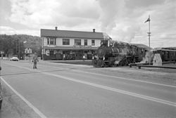
The East Broad Top Railroad ran through Orbisonia, 1986
Huntingdon County Pennsylvania Incorporated and Unincorporated areas Orbisonia Highlighted.svg
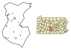
Location of Orbisonia in Huntingdon County, Pennsylvania.
USA Pennsylvania location map.svg
Red pog.svg
Orbisonia
Usa edcp location map.svg
Red pog.svg
Orbisonia
Coordinates: 40°14′36″N77°53′36″W / 40.24333°N 77.89333°W / 40.24333; -77.89333
Country United States
State Pennsylvania
County Huntingdon
Government
  TypeBorough Council
  Mayor Linda ClarkBorough President Stephen E Scott
Area
[1]
  Total0.10 sq mi (0.25 km2)
  Land0.10 sq mi (0.25 km2)
  Water0.00 sq mi (0.00 km2)
Population
 (2020) [2]
  Total449
  Density4,581.63/sq mi (1,776.17/km2)
Time zone UTC-5 (Eastern (EST))
  Summer (DST) UTC-4 (EDT)
ZIP code
17243
Area code 814
FIPS code 42-56928
Local phone exchanges: 447, 448

Orbisonia is a borough in Huntingdon County, Pennsylvania, United States. The population was 428 at the 2010 census. [3]

Contents

Keystone marker on Croghan Pike (US 522) in Orbisonia, July 2016 Orbisonia Keystone Marker.jpg
Keystone marker on Croghan Pike (US 522) in Orbisonia, July 2016

Geography

Orbisonia is located in southeastern Huntingdon County at 40°14′36″N77°53′36″W / 40.24333°N 77.89333°W / 40.24333; -77.89333 (40.243345, -77.893362), [4] on the northeastern side of Blacklog Creek, a tributary of Aughwick Creek and part of the Juniata River watershed. Orbisonia is bordered to the southwest by Rockhill, across Blacklog Creek. Blacklog Mountain overlooks the borough to the east.

U.S. Route 522 passes through Orbisonia, leading north 10 miles (16 km) to Mount Union and south 5 miles (8 km) to Shade Gap.

According to the United States Census Bureau, Orbisonia has a total area of 0.097 square miles (0.25 km2), all land. [3]

Demographics

Historical population
CensusPop.Note
1860 188
1870 177−5.9%
1880 766332.8%
1890 96325.7%
1900 653−32.2%
1910 618−5.4%
1920 68210.4%
1930 7418.7%
1940 729−1.6%
1950 648−11.1%
1960 643−0.8%
1970 554−13.8%
1980 506−8.7%
1990 447−11.7%
2000 425−4.9%
2010 4280.7%
2020 4494.9%
Sources: [5] [6] [7] [2]

At the 2000 census there were 425 people, 198 households, and 109 families residing in the borough. The population density was 4,790.2 inhabitants per square mile (1,849.5/km2). There were 217 housing units at an average density of 2,445.8 per square mile (944.3/km2). The racial makeup of the borough was 99.06% White, 0.24% African American, 0.24% Native American, and 0.47% from two or more races. Hispanic or Latino of any race were 0.47%. [6]

There were 198 households, 24.2% had children under the age of 18 living with them, 42.4% were married couples living together, 8.6% had a female householder with no husband present, and 44.9% were non-families. 44.4% of households were made up of individuals, and 29.8% were one person aged 65 or older. The average household size was 2.15 and the average family size was 3.00.

In the borough, the population was spread out, with 22.8% under the age of 18, 4.7% from 18 to 24, 24.0% from 25 to 44, 21.4% from 45 to 64, and 27.1% 65 or older. The median age was 44 years. For every 100 females, there were 90.6 males. For every 100 females age 18 and over, there were 82.2 males.

The median household income was $25,000 and the median family income was $38,333. Males had a median income of $31,250 versus $20,625 for females. The per capita income for the borough was $16,911. About 5.8% of families and 11.0% of the population were below the poverty line, including 7.4% of those under age 18 and 19.8% of those age 65 or over.

Public services

Emergency services

Health care

Postal services

Non-profit organizations

See also

Related Research Articles

<span class="mw-page-title-main">Huntingdon County, Pennsylvania</span> County in Pennsylvania, United States

Huntingdon County is a county in the Commonwealth of Pennsylvania. As of the 2020 census, the population was 44,092. Its county seat is Huntingdon. The county was created on September 20, 1787, mainly from the northern part of Bedford County, plus an addition of territory on the east from Cumberland County.

<span class="mw-page-title-main">East Rockhill Township, Pennsylvania</span> Township in Pennsylvania, United States

East Rockhill Township is a township in Bucks County, Pennsylvania, United States. The original Rockhill Township was established in 1740 and was divided into East and West Rockhill Townships in 1890. The population was 5,706 at the 2010 Census. East Rockhill is part of Pennridge School District. Pennridge Airport is located in East Rockhill Township.

<span class="mw-page-title-main">Richland Township, Bucks County, Pennsylvania</span> Township in Pennsylvania, United States

Richland Township is a township in Bucks County, Pennsylvania, United States. The population was 11,100 at the 2010 census.

<span class="mw-page-title-main">Folcroft, Pennsylvania</span> Borough in Pennsylvania, United States

Folcroft is a borough in Delaware County, Pennsylvania, United States. The population was 6,606 at the 2010 census, down from 6,978 at the 2000 census.

<span class="mw-page-title-main">Fannett Township, Pennsylvania</span> Township in Pennsylvania, United States

Fannett Township is a township in Franklin County, Pennsylvania, United States. The population was 2,483 at the 2020 census. The township derives its name as an older variant spelling of Fanad, County Donegal, from early Irish settlement in the area. It was formed before 1762, and until about 1795 included the area now in Metal Township.

<span class="mw-page-title-main">Metal Township, Pennsylvania</span> Township in Pennsylvania, United States

Metal Township is a township that is located in Franklin County, Pennsylvania, United States. The population was 1,768 at the time of the 2020 census.

<span class="mw-page-title-main">Mapleton, Pennsylvania</span> Borough in Pennsylvania, United States

Mapleton is a borough in Huntingdon County, Pennsylvania, United States. The population was 441 at the 2010 census. It is located on the Juniata River, which is a tributary of the Susquehanna River.

<span class="mw-page-title-main">Mill Creek, Pennsylvania</span> Borough in Pennsylvania, United States

Mill Creek is a borough in Huntingdon County, Pennsylvania, United States. The population was 328 at the 2010 census.

<span class="mw-page-title-main">Petersburg, Pennsylvania</span> Borough in Pennsylvania, United States

Petersburg is a borough in Huntingdon County, Pennsylvania, United States. It was a stop on the former Pennsylvania Railroad Main Line between Tyrone and Huntingdon and the junction point for the Petersburg Branch. The population was 480 at the 2010 census.

<span class="mw-page-title-main">Rockhill, Pennsylvania</span> Borough in Pennsylvania, United States

Rockhill or Rockhill Furnace is a borough in Huntingdon County, Pennsylvania, United States. The population was 371 at the 2010 census, down from 414 at the 2000 census. It is the site of the East Broad Top Railroad and the Rockhill Trolley Museum.

<span class="mw-page-title-main">Shade Gap, Pennsylvania</span> Borough in Pennsylvania, United States

Shade Gap is a borough in Huntingdon County, Pennsylvania, United States. The population was 105 at the 2010 census.

<span class="mw-page-title-main">Shirleysburg, Pennsylvania</span> Borough in Pennsylvania, United States

Shirleysburg is a borough in Huntingdon County, Pennsylvania, United States. The population was 150 at the 2010 census.

<span class="mw-page-title-main">Three Springs, Pennsylvania</span> Borough in Pennsylvania, United States

Three Springs is a borough in Huntingdon County, Pennsylvania, United States. The population was 444 at the 2010 census.

<span class="mw-page-title-main">Union Township, Huntingdon County, Pennsylvania</span> Township in Pennsylvania, United States

Union Township is a township in Huntingdon County, Pennsylvania, United States. The population was 951 at the 2020 census.

<span class="mw-page-title-main">Lack Township, Juniata County, Pennsylvania</span> Township in Pennsylvania, United States

Lack Township is a township that is located in Juniata County, Pennsylvania, United States. The population was 637 at the time of the 2020 census.

<span class="mw-page-title-main">Paint, Pennsylvania</span> Borough in Pennsylvania, United States

Paint is a borough in Somerset County, Pennsylvania, United States. The population was 907 at the 2020 census. It is part of the Johnstown, Pennsylvania Metropolitan Statistical Area.

<span class="mw-page-title-main">Tioga Township, Tioga County, Pennsylvania</span> Township in Pennsylvania, United States

Tioga Township is a township in Tioga County, Pennsylvania, United States. The population was 941 at the 2020 census.

<span class="mw-page-title-main">Irwin, Pennsylvania</span> Borough in Pennsylvania, United States

Irwin is a borough in Westmoreland County, Pennsylvania, 22 miles (35 km) southeast of Pittsburgh. Some of the most extensive bituminous coal deposits in the commonwealth are located here. In the past, iron foundries, flour mills, car shops, facing and planing mills, electricals goods, and mirror factories provided employment to the residents. In 1900, the population numbered 2,452; it increased to 2,886 in 1910. The population was 3,973 at the 2010 census.

<span class="mw-page-title-main">Sewickley Township, Pennsylvania</span> Township in Pennsylvania, United States

Sewickley Township is a township in Westmoreland County, Pennsylvania, United States. The population was 5,590 at the 2020 census.

<span class="mw-page-title-main">Trafford, Pennsylvania</span> Borough in Pennsylvania, United States

Trafford is a borough in Allegheny and Westmoreland counties in the U.S. state of Pennsylvania. Located near Pittsburgh in western Pennsylvania, the borough lies primarily in Westmoreland County; only a small portion extends into Allegheny County. It was incorporated in 1904 from the northernmost corner of North Huntingdon Township, and was named by George Westinghouse for Trafford near Manchester, England. Westinghouse purchased the land in 1902, and the Trafford Foundry began operations on October 3, 1903. The population was 3,317 at the 2020 census. Of this, 3,113 were in Westmoreland County, and only 61 were in Allegheny County.

References

  1. "ArcGIS REST Services Directory". United States Census Bureau. Retrieved October 12, 2022.
  2. 1 2 "Census Population API". United States Census Bureau. Retrieved Oct 12, 2022.
  3. 1 2 "Geographic Identifiers: 2010 Census Summary File 1 (G001): Orbisonia borough, Pennsylvania". American Factfinder. U.S. Census Bureau. Archived from the original on February 13, 2020. Retrieved January 22, 2018.
  4. "US Gazetteer files: 2010, 2000, and 1990". United States Census Bureau. 2011-02-12. Retrieved 2011-04-23.
  5. "Census of Population and Housing". U.S. Census Bureau. Retrieved 11 December 2013.
  6. 1 2 "U.S. Census website". United States Census Bureau . Retrieved 2008-01-31.
  7. "Incorporated Places and Minor Civil Divisions Datasets: Subcounty Resident Population Estimates: April 1, 2010 to July 1, 2012". Population Estimates. U.S. Census Bureau. Archived from the original on June 11, 2013. Retrieved 11 December 2013.

Commons-logo.svg Media related to Orbisonia, Pennsylvania at Wikimedia Commons