Spruce Creek Township, Pennsylvania

Last updated

Spruce Creek Township, Pennsylvania
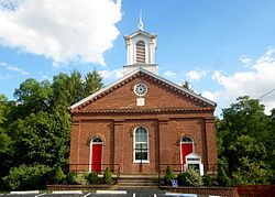
Lower Spruce Creek Presbyterian Huntingdon Co PA.jpg
Lower Spruce Creek Presbyterian Church in the village of Spruce Creek
Map of Huntingdon County, Pennsylvania Highlighting Spruce Creek Township.PNG
Map of Huntingdon County, Pennsylvania Highlighting Spruce Creek Township
Map of Pennsylvania highlighting Huntingdon County.svg
Map of Huntingdon County, Pennsylvania
Country United States
State Pennsylvania
County Huntingdon
Area
[1]
  Total8.55 sq mi (22.13 km2)
  Land8.46 sq mi (21.92 km2)
  Water0.08 sq mi (0.21 km2)
Population
 (2020) [2]
  Total201 Decrease2.svg
  Density28.00/sq mi (9.078/km2)
Time zone UTC-5 (Eastern (EST))
  Summer (DST) UTC-4 (EDT)
FIPS code 42-061-73488

Spruce Creek Township is a township that is located in Huntingdon County, Pennsylvania, United States. The population was 201 at the time of the 2020 census. [2]

Contents

Geography

According to the United States Census Bureau, the township has a total area of 8.2 square miles (21.4 km2), of which 8.2 square miles (21.2 km2) is land and 0.1 square mile (0.2 km2) (0.73%) is water.

Demographics

Historical population
CensusPop.Note
1900 789
1910 757−4.1%
1920 718−5.2%
1930 525−26.9%
1940 386−26.5%
1950 338−12.4%
1960 335−0.9%
1970 3483.9%
1980 3665.2%
1990 281−23.2%
2000 263−6.4%
2010 238−9.5%
2020 201−15.5%
2022 (est.)198 [2] −1.5%
U.S. Decennial Census [3]

As of the census [4] of 2000, there were 263 people, 117 households, and 76 families residing in the township.

The population density was 32.1 inhabitants per square mile (12.4/km2). There were 146 housing units at an average density of 17.8/sq mi (6.9/km2).

The racial makeup of the township was 100.00% White.

There were 117 households, out of which 29.9% had children under the age of 18 living with them; 54.7% were married couples living together, 7.7% had a female householder with no husband present, and 34.2% were non-families. 31.6% of all households were made up of individuals, and 11.1% had someone living alone who was 65 years of age or older.

The average household size was 2.25 and the average family size was 2.77.

Within the township, the population was spread out, with 21.3% of residents who were under the age of 18, 5.3% from 18 to 24, 27.4% from 25 to 44, 33.8% from 45 to 64, and 12.2% who were 65 years of age or older. The median age was 43 years.

For every 100 females, there were 97.7 males. For every 100 females age 18 and over, there were 89.9 males.

The median income for a household in the township was $33,750, and the median income for a family was $47,188. Males had a median income of $30,156 versus $26,250 for females.

The per capita income for the township was $18,148.

Approximately 5.2% of families and 9.2% of the population were living below the poverty line, including 3.4% of those under the age of eighteen and 11.5% of those who were sixty-five or older.

Related Research Articles

<span class="mw-page-title-main">Fraser, Iowa</span> City in Iowa, United States

Fraser is a city in Dodge Township, Boone County, Iowa, United States. The population was 101 at the time of the 2020 census. It is part of the Boone, Iowa Micropolitan Statistical Area, which is a part of the larger Ames–Boone Combined Statistical Area. The city is located along the Des Moines River.

<span class="mw-page-title-main">Walkerville, Michigan</span> Village in Michigan, United States

Walkerville is a village in Oceana County of the U.S. state of Michigan. The population was 247 at the 2010 census. The village is located within Leavitt Township.

Island Lake Township is a township in Lyon County, Minnesota, United States. The population was 208 at the 2000 census.

Floodwood Township is a township in Saint Louis County, Minnesota, United States. The population was 280 at the 2010 census. The township took its name from the Floodwood River.

Arthur Township is a township in Traverse County, Minnesota, United States. The population was 109 at the 2000 census.

Antrim Township is a township in Watonwan County, Minnesota, United States. The population was 291 at the 2000 census.

<span class="mw-page-title-main">Upper Yoder Township, Pennsylvania</span> Township in Pennsylvania, United States

Upper Yoder Township is a township in Cambria County, Pennsylvania, United States. The population was 5,449 at the 2010 census. It is part of the Johnstown, Pennsylvania Metropolitan Statistical Area.

<span class="mw-page-title-main">West Carroll Township, Pennsylvania</span> Township in Pennsylvania, United States

West Carroll Township is a township in Cambria County, Pennsylvania, United States and consists of the communities of Bakerton, Barnes, Carrolltown Road, Elmora and St. Benedict. The population was 1,296 at the 2010 census. It is part of the Johnstown, Pennsylvania Metropolitan Statistical Area.

<span class="mw-page-title-main">West Taylor Township, Pennsylvania</span> Township in Pennsylvania, United States

West Taylor Township is a township that is located in Cambria County, Pennsylvania, United States. The population was 795 at the time of the 2010 census.

<span class="mw-page-title-main">White Township, Cambria County, Pennsylvania</span> Township in Pennsylvania, United States

White Township is a township that is located in Cambria County, Pennsylvania, United States. The population was 836 at the time of the 2010 census.

<span class="mw-page-title-main">Goshen Township, Clearfield County, Pennsylvania</span> Township in Pennsylvania, United States

Goshen Township is a township in Clearfield County, Pennsylvania, United States. The population was 393 at the 2020 census.

<span class="mw-page-title-main">Union Township, Clearfield County, Pennsylvania</span> Township in Pennsylvania, United States

Union Township is a township that is located in Clearfield County, Pennsylvania, United States. The population was 880 at the time of the 2020 census.

<span class="mw-page-title-main">South Middleton Township, Pennsylvania</span> Township in Pennsylvania, United States

South Middleton Township is a township in Cumberland County, Pennsylvania, United States. The population was 14,663 at the 2010 census, up from 12,939 at the 2000 census.

<span class="mw-page-title-main">Upper Paxton Township, Pennsylvania</span> Township in Pennsylvania, United States

Upper Paxton Township is a township in Dauphin County, Pennsylvania, United States. The population was 4,014 at the 2020 census.

<span class="mw-page-title-main">Millstone Township, Pennsylvania</span> Township in Pennsylvania, United States

Millstone Township is a township in Elk County, Pennsylvania, United States. The population was 95 at the 2020 census, up from 82 in 2010.

<span class="mw-page-title-main">Broad Top City, Pennsylvania</span> Borough in Pennsylvania, United States

Broad Top City is a borough in Huntingdon County, Pennsylvania, United States. The population was 371 at the 2020 census, a decline from the figure of 452 tabulated in 2010.

<span class="mw-page-title-main">Morris Township, Huntingdon County, Pennsylvania</span> Township in Pennsylvania, United States

Morris Township is a township that is located in Huntingdon County, Pennsylvania, United States. The population was 424 at the time of the 2020 census.

<span class="mw-page-title-main">Annin Township, Pennsylvania</span> Township in Pennsylvania, United States

Annin Township is a township in McKean County, Pennsylvania, United States.

<span class="mw-page-title-main">Union Township, Mifflin County, Pennsylvania</span> Township in Pennsylvania, United States

Union Township is a township in Mifflin County, Pennsylvania, United States. The population was 3,655 at the time of the 2020 census.

<span class="mw-page-title-main">Carroll Township, Washington County, Pennsylvania</span> Township in Pennsylvania, United States

Carroll Township is a township in Washington County, Pennsylvania, United States. The population was 5,381 at the 2020 census.

References

  1. "2016 U.S. Gazetteer Files". United States Census Bureau. Retrieved August 14, 2017.
  2. 1 2 3 Bureau, US Census. "City and Town Population Totals: 2020-2022". Census.gov. US Census Bureau. Retrieved January 31, 2024.
  3. "Census of Population and Housing". Census.gov. Retrieved June 4, 2016.1970-1990 Census: "1990 Census of Population and Housing Population and Housing Unit Counts: Pennsylvania"
  4. "U.S. Census website". United States Census Bureau . Retrieved January 31, 2008.

40°37′36″N78°07′28″W / 40.62667°N 78.12444°W / 40.62667; -78.12444