
The City Loop is a piece of underground commuter rail infrastructure in the central business district (CBD) of Melbourne, Victoria, Australia

Bondi Junction is an eastern suburb of Sydney, in the state of New South Wales, Australia. It is 6 kilometres east of the Sydney central business district and is part of the local government area of Waverley.

Central is a heritage-listed railway station located in the centre of Sydney, New South Wales, Australia. The station is the largest and busiest railway station in Australia and serves as a major transport interchange for NSW TrainLink inter-city rail services, Sydney Trains commuter rail services, Sydney light rail services, bus services, and private coach transport services. The station is also known as Sydney Terminal. The property was added to the New South Wales State Heritage Register on 2 April 1999. It recorded 85.4 million passenger movements in 2018 and serves over 250,000 people daily.
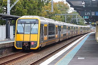
The Eastern Suburbs & Illawarra Line is a commuter railway line in the eastern and southern suburbs of Sydney and is a part of the Sydney Trains network. The line was constructed in the 1880s to Wollongong to take advantage of agricultural and mining potentials in the Illawarra area. In March 1926, it became the first railway in New South Wales to run electric train services.

Sunshine railway station is located on the Sunbury line in Victoria, Australia. Originally named Braybrook Junction for the convergence of the major railways from central Melbourne to Ballarat and Bendigo, it was renamed when the suburb of Sunshine, which it serves, took its name from the nearby Sunshine Harvester Works. With the expansion of the railway network in Melbourne's west, Sunshine grew in importance, with cross-suburban goods routes constructed to Newport and from the adjacent Albion to Jacana line. From the mid-20th century, it became an interchange for the main interstate routes to South Australia and New South Wales, when the through line from Melbourne to Sydney was completed, although the main line to Adelaide was later diverted. In the early 21st century, the station was demolished and reconstructed to serve the diversion of the main passenger route to Geelong and beyond. It has been identified as a possible route for a future line to Melbourne Airport and as an interchange for the orbital Suburban Rail Loop.

Museum railway station is a heritage-listed underground commuter rail station that is located on the City Circle route at the southern end of Hyde Park in the Sydney central business district of New South Wales, Australia. The station is served by Sydney Trains T2 Inner West & Leppington and T3 Bankstown T8 Airport & South lines. The station is named after the nearby Australian Museum. It was added to the New South Wales State Heritage Register on 2 April 1999.

The Sydney central business district (CBD) is the historical and main commercial centre of Sydney. The CBD is Sydney's city centre, or Sydney City, and the two terms are used interchangeably. Colloquially, the CBD or city centre is often referred to simply as "Town" or "the City". The Sydney city centre extends southwards for about 3 km (2 mi) from Sydney Cove, the point of first European settlement in which the Sydney region was initially established.

Martin Place is a pedestrian mall in the Sydney central business district, New South Wales, Australia. Martin Place has been described as the "civic heart" of Sydney. As home to the Reserve Bank of Australia, the Commonwealth Bank, Macquarie Bank, Westpac and other corporations, it is also a centre of business and finance. The Sydney GPO is also located on Martin Place.
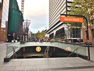
Martin Place railway station is a heritage-listed underground commuter rail station located on the Eastern Suburbs line, serving the Sydney central business district in New South Wales, Australia. Named after Martin Place, it is served by Sydney Trains T4 Eastern Suburbs & Illawarra Line services and NSW TrainLink South Coast Line services. It was designed by Fowell, Mansfield Jarvis and McLurcan and built from 1973 to 1979. It was added to the New South Wales State Heritage Register on 2 April 1999.

Sydney, the largest city in Australia, has an extensive network of passenger and freight railways. The passenger system includes an extensive suburban railway network, operated by Sydney Trains, a metro network and a light rail network. A dedicated freight network also exists. Future expansion of the light rail network includes the Parramatta Light Rail. Existing light rail services are the Inner West Light Rail and the CBD & South East Light Rail.

Metrobus is a high frequency, high capacity bus network in Sydney, Australia, first introduced in 2008. Metrobus services run every 10 minutes during peak periods, 15 minutes during off-peak weekday periods, and 20 minutes on weekends, linking key commercial suburbs and centres throughout the city, with the intention of making timetables obsolete. All buses were initially painted in a distinctive red livery but recently, the standard Transport for NSW livery of blue and white has been adopted. All Metrobus services are wheelchair accessible. All route numbers were prefixed with an "M" followed by a two-digit number.
Various railway lines have been proposed for Sydney, Australia, including both heavy rail extensions to the existing network, and more recently proposals for metro style lines–one of which was completed in 2019.

The Metro Tunnel is a metropolitan rail project currently under construction in Melbourne, Victoria, Australia. It includes the construction of twin 9-kilometre (5.6 mi) rail tunnels between South Kensington and South Yarra with five new underground stations. The tunnel will connect the Pakenham and Cranbourne lines with the Sunbury line, creating a new cross-city line that bypasses Flinders Street station and the City Loop. The line is also planned to serve Melbourne Airport via a new branch line west of Sunshine station.
The Inner West Light Rail is a 12.8-kilometre (8.0 mi) light rail line in Sydney, New South Wales, Australia, running from Central railway station through the Inner West to Dulwich Hill and serving 23 stops. It is the original line of the Sydney light rail network, and was originally known as Sydney Light Rail. Light rail services on the line are now branded as the L1 Dulwich Hill Line.

The Sydney Metro is a fully-automated, rapid-transit rail system in Sydney, New South Wales, Australia. The first component, the Metro North West Line, opened on 26 May 2019, running from Tallawong to Chatswood. It currently consists of 13 stations and 36 km (22.4 mi) of twin tracks, mostly underground. Work is progressing to extend this line from Chatswood to Bankstown as part of the City & Southwest project, which will run under Sydney Harbour and the Sydney Central Business District (CBD), with a scheduled 2024 completion. When completed, the entire line from Tallawong to Bankstown will have 66 km (41.0 mi) of twin tracks and 31 stations.
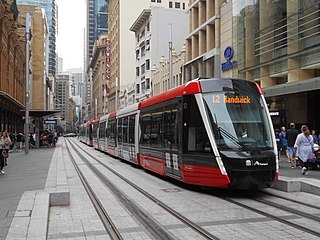
The CBD and South East Light Rail is a light rail line running between Sydney's central business district (CBD) and the south-eastern suburbs of Sydney, New South Wales, Australia. Construction commenced in October 2015, with services between Circular Quay and Randwick commencing on 14 December 2019 as the L2 Randwick Line, and between Circular Quay and Kingsford on 3 April 2020 as the L3 Kingsford Line. It is part of Sydney's light rail network.

Sydney Metro City & Southwest is a 30-kilometre (19 mi) rapid transit project currently under-construction in Sydney, Australia. The project will extend the Metro North West Line from Chatswood on the North Shore, to Bankstown in the city's south-west via the Sydney central business district.
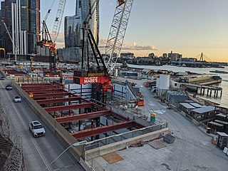
Barangaroo railway station is a future underground rapid transit station for the inner-city Barangaroo precinct in Sydney, Australia. The proposal, announced in 2015, forms part of Transport for NSW's Sydney Metro City & Southwest scheme and would make Barangaroo the first stop for southbound metro trains in the central business district (CBD).
Town Hall railway station is a rapid transit station currently under construction as part of the Metro Tunnel project in Melbourne, Victoria. The station will serve the southern end of the Melbourne central business district (CBD) and will connect to Flinders Street station via an underground pedestrian walkway.
Sydney Metro West is a rapid transit underground rail project currently under construction in Sydney, New South Wales, Australia. It involves constructing a rail line from Hunter St in the northern Sydney City Centre (CBD) to Westmead in the western suburbs of Greater Sydney which will generally run parallel to the existing Main Suburban and Main Western railway lines, but via different suburbs and different stations, with the main aims being the doubling of rail capacity between the City Centre and Greater Western Sydney and the relief of overcrowding on the Western Line. The line will form part of the Sydney Metro network.
