Pleasant Grove Township | |
|---|---|
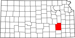
 Location in Greenwood County | |
| Coordinates: 37°47′15″N096°02′33″W / 37.78750°N 96.04250°W | |
| Country | United States |
| State | Kansas |
| County | Greenwood |
| Area | |
• Total | 59.00 sq mi (152.82 km2) |
| • Land | 58.07 sq mi (150.41 km2) |
| • Water | 0.93 sq mi (2.41 km2) 1.58% |
| Elevation | 1,007 ft (307 m) |
| Population (2000) | |
• Total | 52 |
| • Density | 0.78/sq mi (0.3/km2) |
| GNIS feature ID | 0474662 |
Pleasant Grove Township is a township in Greenwood County, Kansas, United States. As of the 2000 census, its population was 52.