Tonovay, Kansas | |
|---|---|
 | |
 Tonovay  Tonovay | |
| Coordinates: 37°51′8″N96°10′41″W / 37.85222°N 96.17806°W [1] | |
| Country | United States |
| State | Kansas |
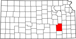
| County | Greenwood |
| Elevation | 1,050 ft (320 m) |
| Time zone | UTC-6 (CST) |
| • Summer (DST) | UTC-5 (CDT) |
| Area code | 620 |
| FIPS code | 20-70850 |
| GNIS ID | 474649 [1] |
Tonovay (also Ton of Hay) is an unincorporated community in Greenwood County, Kansas, United States. [1] It is located approximately five miles east of the city of Eureka along K-99 highway.