Teterville, Kansas | |
|---|---|
 | |
 Teterville  Teterville | |
| Coordinates: 38°2′35″N96°25′14″W / 38.04306°N 96.42056°W [1] | |
| Country | United States |
| State | Kansas |
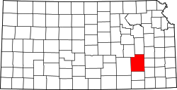
| County | Greenwood |
| Elevation | 1,608 ft (490 m) |
| Population | |
• Total | 0 |
| Time zone | UTC-6 (CST) |
| • Summer (DST) | UTC-5 (CDT) |
| Area code | 620 |
| FIPS code | 20-70275 |
| GNIS ID | 484837 [1] |
Teterville is a ghost town in Greenwood County, Kansas, United States. [1] It is located approximately 11 miles east of Cassoday. No buildings remain of this former community.