Polesie State Radioecological Reserve

Last updated • 4 min readFrom Wikipedia, The Free Encyclopedia
Polesie State Radioecological Reserve
Палескі дзяржаўны радыяцыйна-экалагічны запаведнік (Belarusian)
Полесский государственный радиационно-экологический заповедник (Russian)
Polesie State Radioecological Reserve (OpenStreetMap).png
OSM map of the reserve highlighting some nearby places in the annotations (as Mazyr, Pripyat, the Chernobyl Plant etc). The map in the corner shows its position (red) within Belarus, showing also the Ukrainian, and contiguous, Chernobyl Exclusion Zone (yellow)
Polesie State Radioecological Reserve
Location Belarus
Nearest city Brahin, Narowlya, Khoiniki
Coordinates 51°39′N29°59′E / 51.650°N 29.983°E / 51.650; 29.983
Area2,162 km2 (835 sq mi)
EstablishedJuly 18, 1988 [1]
Official website

The Polesie State Radioecological Reserve (PSRER; Belarusian : Палескі дзяржаўны радыяцыйна-экалагічны запаведнік, romanized: Palyeski dzyarzhawny radyyatsyyna-ekalahichny zapavyednik; Russian : Полесский государственный радиационно-экологический заповедник, romanized: Polessky gosudarstvenny radiatsionno-ekologichesky zapovednik) is a radioecological nature reserve in the Polesie region of Belarus, which was created to enclose the territory of Belarus most affected by radioactive fallout from the Chernobyl disaster. The reserve adjoins the Chernobyl Exclusion Zone in Ukraine. The environmental monitoring and countermeasure agency, Bellesrad, oversees the agriculture and forestry in the area.

Contents

History

Radiation level in 1996, according to map from CIA handbook Chernobyl radiation map 1996.svg
Radiation level in 1996, according to map from CIA handbook

Two years after the Chernobyl disaster, the Belarusian part of the Chernobyl Exclusion Zone was extended to a more highly contaminated area. Then, a closed-to-the-public nature reserve was established in Belarus with a total area of 1,313 km2 (507 sq mi). The reserve was established on July 18, 1988. [1] Before the disaster, over 22,000 people lived there in 96 settlements. The population was evacuated after the disaster. In 1993 it was expanded by 849 km2 (328 sq mi), making it the largest Belarusian nature reserve and one of the largest in Europe.

Geography

Overview

The area, located in southern Gomel Region and bordering the Ukrainian Exclusion Zone, includes part of the raions (districts) of Brahin, Khoiniki and Narowlya. [2] It is crossed by the Pripyat River, and the city of Mazyr is 36 km (22 mi) from the northwestern entrance, in Narowlya. The southern strip is crossed by the Chernihiv–Ovruch railway, which passes through the villages of Kaporanka, Kalyban and Pasudava.

Abandoned villages

The following list shows the abandoned villages included in the reserve. Population refers to the 1959 census. "fam." refers to the number of families evacuated after the 1986 disaster.

Settlement
Pop.
(1959)
Fam.
(1986)
District Belarusian Russian
Aravichy
923
222
Khoiniki Аравічы Оревичи
Babchyn
839
194
Khoiniki Бабчын Бабчин
Bagushi
599
195
Brahin Багушы Богуши
Buda
267
56
KhoinikiБуда Буда
Chamkou
138
29
Khoiniki Чамкоў Чемков
Dzernavichy
1,016
308
Narowlya Дзёрнавічы Дёрновичи
Haroshkau
191
154
KhoinikiГарошкаў Горошков
Kalyban
977
270
Brahin Калыбань Колыбань
Kaporanka
317
70
Brahin Капоранка Капоренка
Kazhushki
869
214
KhoinikiКажушкі Кожушки
Lomachy
177
38
KhoinikiЛомачы Ломачи
Novakukhnaushchyna
135
13
KhoinikiНовакухнаўшчына Новокухновщина
Novy Pakrousk
176
29
KhoinikiНовы Пакроўск Новый Покровск
Pasudava
642
73
Brahin Пасудава Посудово
Pirki
552
476
Brahin Піркі Пирки
Rudyya
245
40
Khoiniki Рудыя Рудые

Fauna and flora

A moose in the reserve Gospodinia pokinutogo khutora.jpg
A moose in the reserve

The reserve hosts many rare and endangered species, which thrive there thanks to the virtual absence of humans. They include European bison, Przewalski horse, moose, brown bear, golden eagle, and white-tailed eagle. It is home to the world's largest population of the European pond turtle. According to PSRER administration, there are 7 reptile, 11 amphibian, 46 mammal, 213 bird and 25 fish species. Of those, 70 are listed in the International Red Book and the Red Book of the Republic of Belarus. Flora includes 1251 registered plants, which is more than two-thirds of the flora of the country, and 18 of the plant species are listed in the Red Book. [3] It was found that voles have higher rates of cataracts, useful populations of bacteria on the wings of birds in the zone are lower, partial albinism is common among barn swallows, and cuckoos have become less common. Serious animal mutations, though, happened only right after the accident. [4]

Activities

Although the reserve was established for the purpose of radiobiological and environmental research, it is of interest to other biologists. Due to the minimal human presence, it is possible to observe the natural development of wildlife in the conditions of Belarus. "In connection with the removal of anthropogenic load and the wealth of flora the ideal conditions for the recovery of the animal world have been created here", states the report of the Committee on the Health Effects of the Chernobyl disaster at the Council of Ministers of Belarus. Some new species, including European bison, have been introduced on the territory of the reserve.

Main activities

Administration of PSRER is located in the town of Khoiniki. The annual budget of PSRER is 4 million USD. Main activities include: [5]

Extra-budgetary activities

The administration uses land in the reserve to earn income in addition to its budget. The purpose is to increase the self-sufficiency of the reserve, save money, increase the salaries of employees and contribute positively to the GDP of Belarus. Activities include:

As of 2004, the herd at the reserve's horse farm numbered 230 horses. Cattle are being bred to endure the conditions of radioactive contamination, and young individuals are sold for further breeding.

During all activities, radionuclide concentrations are monitored to ensure they do not exceed certain limits. [6]

Neighboring nature reserves

Proposed for nature reserves

As of 2024, besides the Polesie State Radioecological Reserve bordering Ukraine, there are also closed areas in other part of Belarus along the Russian border, located east and north of the city of Vetka. These zones are situated in the eastern part of the Gomel region and the southeastern part of the Mogilev region, south of the city of Cherykaw. Signboards mark the boundaries of the area and indicate radiation exposure. Entry to the area is permitted only with permission from the authorities.

See also

Related Research Articles

<span class="mw-page-title-main">Polesia</span> Natural and historical region of Central and Eastern Europe

Polesia, also called Polissia, Polesie, or Polesye, is a natural (geographic) and historical region in Eastern Europe within the East European Plain, including the Belarus–Ukraine border region and part of eastern Poland. This region should not be confused with parts of Russia also traditionally called "Polesie".

<span class="mw-page-title-main">Gomel region</span> Region of Belarus

Gomel region, also known as Gomel oblast or Homyel voblasts, is one of the regions of Belarus. Its administrative center is Gomel. The total area of the region is 40,400 square kilometres (15,600 sq mi). As of 2024, it had a population of 1,338,617.

<span class="mw-page-title-main">Chernobyl exclusion zone</span> Disaster Exclusion Zone in Ukraine

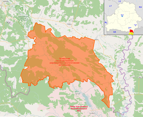
The Chernobyl Nuclear Power Plant Zone of Alienation, also called the 30-Kilometre Zone or simply The Zone, was established shortly after the 1986 Chernobyl disaster in the Ukrainian SSR of the Soviet Union.

Bellesrad (Беллесрад) is a short name for the State Institution for Radiation Monitoring and Radiation Safety of the Republic of Belarus. It is subordinated to the State Forestry Committee of the Council of Ministers of Republic of Belarus. It was created to address the impact of the Chernobyl disaster on Belarus.

<span class="mw-page-title-main">Effects of the Chernobyl disaster</span> Assessment of Chernobyls impact on Earth since 1986

The Chernobyl disaster of 26 April 1986 triggered the release of radioactive contamination into the atmosphere in the form of both particulate and gaseous radioisotopes. As of 2024, it remains the world's largest known release of radioactivity into the natural environment.

An exclusion zone is a territorial division established for various, case-specific purposes.

<span class="mw-page-title-main">Khoiniki</span> Town in Gomel Region, Belarus

Khoiniki is a town in Gomel Region, Belarus. It serves as the administrative center of Khoiniki District. As of 2024, it has a population of 13,167.

<span class="mw-page-title-main">Narowlya</span> Town in Gomel Region, Belarus

Narowlya is a town in Gomel Region, Belarus. It serves as the administrative center of Narowlya District. As of 2024, it has a population of 8,371.

<span class="mw-page-title-main">Brahin district</span> District of Gomel Region, Belarus

Brahin District or Bragin District is a district (raion) of Gomel Region in Belarus. Its administrative seat is the town of Brahin. As of 2024, it has a population of 11,726.

<span class="mw-page-title-main">Khoiniki district</span> District of Gomel Region, Belarus

Khoiniki District or Chojniki District is a district (raion) of Gomel Region in Belarus. Its administrative center is the town of Khoiniki. As of 2024, it has a population of 18,435.

<span class="mw-page-title-main">Narowlya district</span> District of Gomel Region, Belarus

Narowlya District or Naroŭlia District is a district (raion) of Gomel Region in Belarus. Its administrative center is the town of Narowlya. As of 2024, it has a population of 10,417.

<span class="mw-page-title-main">Deaths due to the Chernobyl disaster</span> The death toll of the 1986 Chernobyl incident

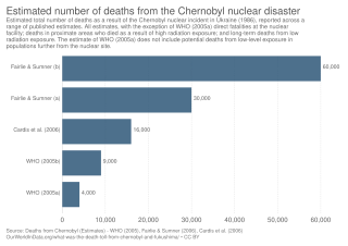
The Chernobyl disaster, considered the worst nuclear disaster in history, occurred on 26 April 1986 at the Chernobyl Nuclear Power Plant in the Ukrainian Soviet Socialist Republic, then part of the Soviet Union, now in Ukraine. From 1986 onward, the total death toll of the disaster has lacked consensus; as peer-reviewed medical journal The Lancet and other sources have noted, it remains contested. There is consensus that a total of approximately 30 people died from immediate blast trauma and acute radiation syndrome (ARS) in the seconds to months after the disaster respectively, with 60 in total in the decades since, inclusive of later radiation induced cancer. However, there is considerable debate concerning the accurate number of projected deaths that have yet to occur due to the disaster's long-term health effects; long-term death estimates range from up to 4,000 for the most exposed people of Ukraine, Belarus, and Russia, to 16,000 cases in total for all those exposed on the entire continent of Europe, with figures as high as 60,000 when including the relatively minor effects around the globe. Such numbers are based on the heavily contested linear no-threshold model.

<span class="mw-page-title-main">Belarus–Ukraine border</span> International border

The Belarusian-Ukrainian border is the state border between Belarus and Ukraine with a length of about 1,084 km (674 mi). It starts from the triple junction with Poland to the west and stretches to the triple junction with Russia to the east. The tripoint border at the triple border junction of Belarus, Russia and Ukraine is marked in the form of a monument, while at the other border junction there is a river, the Western Bug that coincides with the border of Poland.

The protected areas of Belarus are governed by the 1994 law "About the Protected Nature Areas". and its amendments.

<span class="mw-page-title-main">Vilcha, Kyiv Oblast</span> Urban-type settlement in Kyiv Oblast, Ukraine

Vilcha is an abandoned settlement and former urban-type settlement in the Chernobyl Exclusion Zone, part of Vyshhorod Raion, Kyiv Oblast, Ukraine.

<span class="mw-page-title-main">Chernihiv–Ovruch railway</span> Railway line in Ukraine and Belarus

The Chernihiv–Ovruch railway is a partially electrified and partially operational single track railway line that stretches between the town of Ovruch and the city of Chernihiv, in northern Ukraine, passing through southern Belarus and the Chernobyl Exclusion Zone. The line is owned by Ukrzaliznytsia alone, with railway stations located in Belarus being leased from the government of Belarus. A portion of the line between railway stations Vilcha and Semykhody has not been in service since the Chernobyl disaster, on 26 April 1986.

Aravichy is an abandoned village in Khoiniki District, Gomel Region, Belarus.

Dzernavichy or Dernovichi is an abandoned village in Narowlya District, Gomel Region, Belarus.

<span class="mw-page-title-main">Chernobyl groundwater contamination</span> Groundwater contaminated from the Chernobyl disaster

The Chernobyl disaster remains the major and most detrimental nuclear catastrophe which completely altered the radioactive background of the Northern Hemisphere. It happened in April 1986 on the territory of the former Soviet Union. The catastrophe led to the increase of radiation in nearly one million times in some parts of Europe and North America compared to the pre-disaster state. Air, water, soils, vegetation and animals were contaminated to a varying degree. Apart from Ukraine and Belarus as the worst hit areas, adversely affected countries included Russia, Austria, Finland and Sweden. The full impact on the aquatic systems, including primarily adjacent valleys of Pripyat river and Dnieper river, are still unexplored.

<span class="mw-page-title-main">Capture of Chernobyl</span> Part of the 2022 Russian invasion of Ukraine

During the Russian invasion of Ukraine, the Chernobyl Exclusion Zone was captured on 24 February 2022, the first day of the invasion, by the Russian Armed Forces, who entered Ukrainian territory from neighbouring Belarus and seized the entire area of the Chernobyl Nuclear Power Plant by the end of that day. On 7 March, it was reported that around 300 people were trapped and had been unable to leave the power plant since its capture. On 31 March, it was reported that most of the Russian troops occupying the area had withdrawn, as the Russian military abandoned the Kyiv offensive to focus on operations in Eastern Ukraine.

References

  1. 1 2 "Polesie State Radioecological Reserve: about". Archived from the original on 2014-06-22. Retrieved 2014-06-27.
  2. 253459229 Polesie State Radioecological Reserve on OpenStreetMap
  3. "Общество | Гомельская область | Гомель". www.gomel-region.by (in Russian). Archived from the original on 2007-05-10. Retrieved 2018-03-31.
  4. "Animals Rule Chernobyl Three Decades After Nuclear Disaster". National Geographic News. 2016-04-18. Archived from the original on April 18, 2016. Retrieved 2019-05-13.
  5. "About (zapovednik.by)". Archived from the original on 2014-06-22. Retrieved 2014-06-27.
  6. "Внебюджетная деятельность". Archived from the original on 2016-03-03. Retrieved 2014-12-30.