The Province of Alsace (Province d'Alsace) was an administrative region of the Kingdom of France and one of the many provinces formed in the late 1600s. In 1648, the Landgraviate of Upper-Alsace was absorbed into the Kingdom of France and subsequently became the Province of Alsace, which it remain an integral part of for almost 150 years. In 1790, as a result of the decree dividing France into departments, the province was disestablished and split into three departments: Bas-Rhin (Lower Rhine), Haut-Rhin (Upper Rhine), and part of Moselle.
In 1469, following the Treaty of Saint-Omer, Upper Alsace was sold by Archduke Sigismund of Austria to Charles the Bold, Duke of Burgundy. Although Charles was the nominal landlord, taxes were paid to Frederick III, Holy Roman Emperor. The latter was able to use this tax and a dynastic marriage to his advantage to gain back full control of Upper Alsace (apart from the free towns, but including Belfort) in 1477 when it became part of the demesne of the Habsburg family, who were also rulers of the empire. The town of Mulhouse joined the Swiss Confederation in 1515, where it was to remain until 1798.
By the time of the Protestant Reformation in the 16th century, Strasbourg was a prosperous community, and its inhabitants accepted Protestantism in 1523. Martin Bucer was a prominent Protestant reformer in the region. His efforts were countered by the Roman Catholic Habsburgs who tried to eradicate heresy in Upper Alsace. As a result, Alsace was transformed into a mosaic of Catholic and Protestant territories. On the other hand, Mömpelgard (Montbéliard) to the southwest of Alsace, belonging to the Counts of Württemberg since 1397, remained a Protestant enclave in France until 1793.
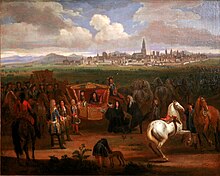
Louis XIV receiving the keys of Strasbourg in 1681
This situation prevailed until 1639, when most of Alsace was conquered by France to keep it out of the hands of the Spanish Habsburgs, who by secret treaty in 1617 had gained a clear road to their valuable and rebellious possessions in the Spanish Netherlands, the Spanish Road. Beset by enemies and seeking to gain a free hand in Hungary, the Habsburgs sold their Sundgau territory (mostly in Upper Alsace) to France in 1646, which had occupied it, for the sum of 1.2million Thalers. When hostilities were concluded in 1648 with the Treaty of Westphalia, most of Alsace was recognized as part of France, although some towns remained independent. The treaty stipulations regarding Alsace were complex. Although the French king gained sovereignty, existing rights and customs of the inhabitants were largely preserved. France continued to maintain its customs border along the Vosges mountains where it had been, leaving Alsace more economically oriented to neighbouring German-speaking lands. The German language remained in use in local administration, in schools, and at the (Lutheran) University of Strasbourg, which continued to draw students from other German-speaking lands. The 1685 Edict of Fontainebleau, by which the French king ordered the suppression of French Protestantism, was not applied in Alsace. France did endeavour to promote Catholicism. Strasbourg Cathedral, for example, which had been Lutheran from 1524 to 1681, was returned to the Catholic Church. However, compared to the rest of France, Alsace enjoyed a climate of religious tolerance.
France consolidated its hold with the 1679 Treaties of Nijmegen, which brought most remaining towns under its control. France seized Strasbourg in 1681 in an unprovoked action. These territorial changes were recognised in the 1697 Treaty of Ryswick that ended the War of the Grand Alliance. But Alsace still contained islands of territory nominally under the sovereignty of German princes and an independent city-state at Mulhouse. These enclaves were established by law, prescription and international consensus.[1]
Government
Map showing the regions of Alsace (grey on far right), Champagne (green on far left), Ardennes (orange centre-left), and Lorraine (pink centre-right) within the borders of modern departments.
Following the governmental reforms of 1773, the Province of Alsace formed part of the Government of Alsace (Gouvernement d'Alsace). The province itself was further divided into two 'regions': Lower Alsace (North) and Upper Alsace (South).[2]
Alsace historically was part of the Holy Roman Empire and the German realm of culture. Since the 17th century, the region has passed between German and French control numerous times, resulting in a cultural blend. German traits remain in the more traditional, rural parts of the culture, such as the cuisine and architecture, whereas modern institutions are totally dominated by French culture.
Symbolism
Strasbourg
Strasbourg's arms are the colours of the shield of the Bishop of Strasbourg (a band of red on a white field, also considered an inversion of the arms of the diocese) at the end of a revolt of the burghers during the Middle Ages who took their independence from the teachings of the Bishop. It retains its power over the surrounding area.
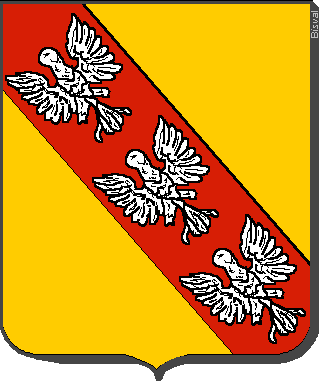
There is controversy around the recognition of the Alsatian flag. The authentic historical flag is the Rot-un-Wiss; Red and White are commonly found on the coat of arms of Alsatian cities (Strasbourg, Mulhouse, Sélestat...)[3] and of many Swiss cities, especially in Basel's region. The German region Hesse uses a flag similar to the Rot-un-Wiss. As it underlines the Germanic roots of the region, it was replaced in 1949 by a new "Union jack-like" flag representing the union of the two départements. It has, however, no real historical relevance. It has been since replaced again by a slightly different one, also representing the two départements. With the purpose of "Francizing" the region, the Rot-un-Wiss has not been recognized by Paris. Some overzealous statesmen have called it a Nazi invention – while its origins date back to the 11th century and the Red and White banner[4] of Gérard de Lorraine (aka. d'Alsace). The Rot-un-Wiss flag is still known as the real historical emblem of the region by most of the population and the départements' parliaments and has been widely used during protests against the creation of a new "super-region" gathering Champagne-Ardennes, Lorraine and Alsace, namely on Colmar's statue of liberty.[5]
Language
Although German dialects were spoken in Alsace for most of its history, the dominant language in Alsace today is French.
Although Alsace has been part of France multiple times in the past, the region had no direct connection with the French state for several centuries. From the end of the Roman Empire (5th century) to the French annexation (17th century), Alsace was politically part of the German world.
The towns of Alsace were the first to adopt the German language as their official language, instead of Latin, during the Lutheran Reform. It was in Strasbourg that German was first used for the liturgy. It was also in Strasbourg that the first German Bible was published in 1466.
Alsace is a cultural region and a territorial collectivity in eastern France, on the west bank of the upper Rhine next to Germany and Switzerland. In January 2021, it had a population of 1,919,745. Alsatian culture is characterized by a blend of German and French influences.
The Duchy of Lorraine, originally Upper Lorraine, was a duchy now included in the larger present-day region of Lorraine in northeastern France. Its capital was Nancy.
Bas-Rhin is a département in Alsace which is a part of the Grand Est super-region of France. The name means 'Lower Rhine', referring to its lower altitude among the two French Rhine departments: it is downstream of the Haut-Rhin department. Both belong to the European Upper Rhine region. It is, with the Haut-Rhin, one of the two departments of the traditional Alsace region which until 1871, also included the area now known as the Territoire de Belfort. The more populous and densely populated of the pair, it had 1,152,662 inhabitants in 2021. The prefecture is based in Strasbourg. The INSEE and Post Code is 67.
Haut-Rhin is a département in the Grand Est region, France, bordering both Germany and Switzerland. It is named after the river Rhine. Its name means Upper Rhine. Haut-Rhin is the smaller and less populated of the two departments of the former administrative Alsace region, the other being the Bas-Rhin. Especially after the 1871 cession of the southern territory known since 1922 as Territoire de Belfort, although it is still rather densely populated compared to the rest of metropolitan France. It had a population of 767,083 in 2021.
Alsace–Lorraine, officially the Imperial Territory of Alsace–Lorraine, was a former territory of the German Empire, located in modern day France. It was established in 1871 by the German Empire after it had occupied the region during the Franco-Prussian War. The region was officially ceded to the German Empire in the Treaty of Frankfurt. French resentment about the loss of the territory was one of the contributing factors to World War I. Alsace–Lorraine was ceded to France in 1920 as part of the Treaty of Versailles following Germany's defeat in the war, although already annexed in 1918.
Sélestat is a commune in the Grand Est region of France. An administrative division (sous-préfecture) of the Bas-Rhin department, the town lies on the Ill river, 17 kilometres (11 mi) from the Rhine and the German border. Sélestat is located between the largest communes of Alsace, Strasbourg and Mulhouse.
Sundgau is a geographical territory in the southern Alsace region, on the eastern edge of France. The name is derived from Alemannic German Sunt-gowe, denoting an Alemannic county in the Old High German period. The principal city and historical capital is Altkirch.
Unterelsaß was the northern part of the historical region Alsace or Elsass, inhabited originally by locals speaking Alemannic German. From 1871 to 1918, Bezirk Unterelsaß was the name for the central district (Bezirk) of the imperial territory of Elsaß-Lothringen (Alsace-Lorraine) in the German Empire.
The November 1918 insurgency in Alsace-Lorraine is a series of events which occurred when the region of Alsace–Lorraine passed from German to French sovereignty at the end of World War I. During this month, international events were linked to domestic troubles, particularly the German Revolution.
Dannemarie (French pronunciation:[danmaʁi] is the French name of Dàmmerkìrch, a commune in the Haut-Rhin department in Alsace in north-eastern France. It was the seat of a canton of the same name and is the seat of the Communauté de communes de la Porte d'Alsace.
Les Dernières Nouvelles d'Alsace, commonly known as DNA, is a regional daily French newspaper covering the Alsace region.
The history of the Jews in Alsace is one of the oldest in Europe. It was first attested to in 1165 by Benjamin of Tudela, who wrote about a "large number of learned men" in "Astransbourg"; and it is assumed that it dates back to around the year 1000. Although Jewish life in Alsace was often disrupted by outbreaks of pogroms, at least during the Middle Ages, and reined in by harsh restrictions on business and movement, it has had a continuous existence ever since it was first recorded. At its peak, in 1870, the Jewish community of Alsace numbered 35,000 people.
The Belfort Gap or Burgundian Gate is the area of relatively flat terrain in Eastern France between the Vosges Mountains to the north and the Jura Mountains to the south. It marks the watershed between the drainage basins of the River Rhine to the east and the River Rhône to the west, part of the European Watershed between the North Sea and the Mediterranean Sea. It is also the boundary between the historic regions of Burgundy to the west and Alsace to the east, and as such has marked the Franco-German border for long periods of its history.
The Protestant Reformed Church of Alsace and Lorraine is a Calvinist denomination in Alsace and northeastern Lorraine, France. As a church body, it enjoys the status as an établissement public du culte.
The Left Bank of the Rhine was the region north of Lauterbourg that is now in western Germany and was conquered during the War of the First Coalition and annexed by the First French Republic.
Grand Est is an administrative region in northeastern France. It superseded three former administrative regions, Alsace, Champagne-Ardenne and Lorraine, on 1 January 2016 under the provisional name of Alsace-Champagne-Ardenne-Lorraine, as a result of territorial reform which had been passed by the French Parliament in 2014.
The flag of Alsace is the original red and white flag of the region, and can be traced to the red and white banner of Gerard, Duke of Lorraine in the 11th century.
The history of Alsace has been influenced by the Rhine and its tributaries, a favorable climate, fertile loess soils, and the region's relative accessibility through and around the Vosges. It was first inhabited by early modern humans during the Paleolithic. Peoples speaking Celtic and Germanic languages occupied the region prior to its conquest by Roman armies under the command of Julius Caesar. In the centuries after the fall of Rome the area acquired its name and identity as an early medieval pagus. Since then, suzerainty and effective control have shifted among competing European powers, including the Kingdom of Alamannia, the Frankish Empire, Lotharingia, the Holy Roman Empire, France, and the German Empire. Alsace has remained part of France since the end of the Second World War.
ABCM-Zweisprachigkeit is a network of bilingual community schools, located in the regions of Alsace, Moselle and Baden-Württemberg. The teaching is given in French and German on a 50-50 basis.
The European Collectivity of Alsace is a territorial collectivity in the Alsace region of France. On 1 January 2021, the departments of Bas-Rhin and Haut-Rhin merged into a territorial collectivity but remained part of the region Grand Est. The creation of this new entity was voted by the French Parliament on 25 July 2019 and Law 2019-816 delimiting its powers was promulgated on 2 August 2019.
This page is based on this Wikipedia article Text is available under the CC BY-SA 4.0 license; additional terms may apply. Images, videos and audio are available under their respective licenses.


