Quincy, Kansas

Last updated

Quincy, Kansas
Map of Greenwood Co, Ks, USA.png
USA Kansas location map.svg
Red pog.svg
Quincy
Usa edcp location map.svg
Red pog.svg
Quincy
Coordinates: 37°52′55″N95°59′34″W / 37.88194°N 95.99278°W / 37.88194; -95.99278 [1]
Country United States
State Kansas
County Greenwood
Elevation
[1]
942 ft (287 m)
Time zone UTC-6 (CST)
  Summer (DST) UTC-5 (CDT)
Area code 620
FIPS code 20-58150
GNIS ID 474454 [1]

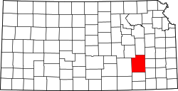
Quincy is an unincorporated community in Greenwood County, Kansas, United States. [1] It is located between Eureka and Yates Center in a rural area.

Contents

History

A post office was opened in Quincy in 1869, and remained in operation until it was discontinued in 1975. [2]

Education

This community and nearby rural areas are served by Hamilton USD 390 public school district.

Related Research Articles

<span class="mw-page-title-main">Greenwood County, Kansas</span> County in Kansas, United States

Greenwood County is a county located in the southeast portion of the U.S. state of Kansas. Its county seat and most populous city is Eureka. As of the 2020 census, the county population was 6,016. The county was named for Alfred Greenwood, a U.S. congressman from Arkansas that advocated Kansas statehood.

<span class="mw-page-title-main">Elk County, Kansas</span> County in Kansas, United States

Elk County is a county located in the U.S. state of Kansas. Its county seat and most populous city is Howard. As of the 2020 census, the county population was 2,483. The county was named for the Elk River.

<span class="mw-page-title-main">Quincy, Illinois</span> City in Illinois, United States

Quincy, known as Illinois's "Gem City", is a city in and the county seat of Adams County, Illinois, United States, located on the Mississippi River. The 2020 census counted a population of 39,463 in the city itself, down from 40,633 in 2010. As of July 1, 2015, the Quincy Micro Area had an estimated population of 77,220. During the 19th century, Quincy was a thriving transportation center as riverboats and rail service linked the city to many destinations west and along the river. It was Illinois' second-largest city, surpassing Peoria in 1870. The city has several historic districts, including the Downtown Quincy Historic District and the South Side German Historic District, which display the architecture of Quincy's many German immigrants from the late 19th century.

<span class="mw-page-title-main">Eureka, Kansas</span> City in Greenwood County, Kansas

Eureka is a city in and the county seat of Greenwood County, Kansas, United States. As of the 2020 census, the population of the city was 2,332.

<span class="mw-page-title-main">Forgottonia</span> Area of Illinois, United States

Forgottonia, also spelled Forgotonia, is the name given to a 16-county region in Western Illinois in the late 1960s and early 1970s. This geographic region forms the distinctive western bulge of Illinois that is roughly equivalent to "The Tract", the Illinois portion of the Military Tract of 1812, along and west of the Fourth Principal Meridian. Since this wedge-shaped region lies between the Illinois and Mississippi rivers, it has historically been isolated from the eastern portion of Central Illinois.

<span class="mw-page-title-main">Central Illinois</span> Region of Illinois, USA

Central Illinois is a region of the U.S. state of Illinois that consists of the entire central third of the state, divided from north to south. Also known as the Heart of Illinois, it is characterized by small towns and mid-sized cities. Agriculture, particularly corn and soybeans, as well as educational institutions and manufacturing centers, figure prominently.

<span class="mw-page-title-main">Elk, Kansas</span> Ghost town in Marion and Chase Counties of Kansas

Elk is a ghost town in Chase and Marion counties in the U.S. state of Kansas. It is currently a ghost town that lays along Middle Creek northwest of Elmdale and straddled the county line between Chase and Marion County.

<span class="mw-page-title-main">Quincy Township, Greenwood County, Kansas</span> Township in Kansas, United States

Quincy Township is a township in Greenwood County, Kansas, USA. As of the 2000 census, its population was 163.

<span class="mw-page-title-main">Lamont, Kansas</span> Unincorporated community in Greenwood County, Kansas

Lamont is an unincorporated community in northeastern Greenwood County, Kansas, United States. It is located approximately 5.5 miles east of the city of Madison along K-58 highway.

<span class="mw-page-title-main">Neal, Kansas</span> Unincorporated community in Greenwood County, Kansas

Neal is an unincorporated community in eastern Greenwood County, Kansas, United States. As of the 2020 census, the population of the community and nearby areas was 37. It is located approximately 10 miles east of the city of Eureka along U.S. Route 54 highway.

<span class="mw-page-title-main">Greenwood, Albemarle County, Virginia</span> Unincorporated community in Virginia, United States

Greenwood is an unincorporated community in Albemarle County, Virginia, United States. It is home to the Greenwood Country Store and the Greenwood Community Center, which has the area's only roller skating rink. Greenwood has a post office with ZIP code 22943 The Greenwood Tunnel, built by Claudius Crozet for the Blue Ridge Railroad and used by the Chesapeake and Ohio Railway until its abandonment during World War II, is near Greenwood by the Buckingham Branch Railroad tracks.

<span class="mw-page-title-main">Piedmont, Kansas</span> Unincorporated community in Greenwood County, Kansas

Piedmont is an unincorporated community in Greenwood County, Kansas, United States. As of the 2020 census, the population of the community and nearby areas was 52. It is located approximately 7 miles (11 km) west of the city of Severy.

<span class="mw-page-title-main">Aulne, Kansas</span> Unincorporated community in Marion County, Kansas

Aulne is an unincorporated community in Marion County, Kansas, United States. The Aulne name was suggested by officials of the railroad when it was built through Aulne during the 19th century. It is located southwest of Marion at the intersection of Pawnee Road and 140th Street next to the Union Pacific Railroad.

<span class="mw-page-title-main">Canada, Kansas</span> Unincorporated community in Marion County, Kansas

Canada is an unincorporated community in Marion County, Kansas, United States. It is named for many Canadian immigrants coming to the area. It is located between Hillsboro and Marion about 0.5 miles south of the intersection of Nighthawk Road and U.S. Route 56 highway, southwest of the Hillsboro Cove of the Marion Reservoir.

<span class="mw-page-title-main">Chicago–Kansas City Expressway</span> Highway in Illinois and Missouri

The Chicago–Kansas City Expressway is a highway that runs between Chicago, Illinois, and Kansas City, Missouri. The road is known as Route 110 in Missouri and Illinois Route 110 (IL 110) in Illinois. IL 110 was created through legislation on May 27, 2010, as the designated route for the Illinois portion of the Chicago–Kansas City Expressway.

<span class="mw-page-title-main">Dubuque, Kansas</span> Unincorporated community in Barton and Russell Counties in Kansas

Dubuque is an unincorporated community in Barton and Russell Counties in the U.S. state of Kansas. It is approximately 10 miles (16 km) south of Dorrance.

<span class="mw-page-title-main">Brainerd, Kansas</span> Unincorporated community in Butler County, Kansas

Brainerd is an unincorporated community in Butler County, Kansas, United States. It is located on the north side of K-196 highway between the cities of Whitewater and Potwin.

<span class="mw-page-title-main">Reece, Kansas</span> Unincorporated community in Greenwood County, Kansas

Reece is an unincorporated community in Greenwood County, Kansas, United States. It is located approximately 7.5 miles west of the city of Eureka.

<span class="mw-page-title-main">Teterville, Kansas</span> Ghost town in Greenwood County, Kansas

Teterville is a ghost town in Greenwood County, Kansas, United States. It is located approximately 11 miles east of Cassoday. No buildings remain of this former community.

<span class="mw-page-title-main">Plum Grove, Kansas</span> Ghost town in Kansas, United States

Plum Grove is a ghost town in Butler County, Kansas, United States. It was located in a rural area north of modern-day Potwin. No buildings remain at this former community site.

References

  1. 1 2 3 4 U.S. Geological Survey Geographic Names Information System: Quincy, Kansas
  2. "Kansas Post Offices, 1828-1961 (archive)". Kansas Historical Society. Archived from the original on October 9, 2013. Retrieved June 10, 2014.

Further reading