Daha is a former village development committee in Jajarkot District in the Karnali province of Nepal. At the time of the 1991 Nepal census it had a population of 3276 residing in 628 individual households.
Hariharpur is a town in Chhireswarnath Municipality in Dhanusa District in the Janakpur Zone of south-eastern Nepal. The formerly Village Development Committee was converted into municipality merging along with existing vedics Ramdaiya, Sakhuwa Mahendranagar, Hariharpur and Digambarpur on 18 May 2014. At the time of the 1991 Nepal census it had a population of 6,259 persons residing in 1133 individual households.
Mahuwa is a village development committee in Dhanusa District in the Janakpur Zone of south-eastern Nepal. At the time of the 1991 Nepal census it had a population of 5,194.
Thulo Lumpek is a town and municipality in Gulmi District in the Lumbini Zone of central Nepal. At the time of the 1991 Nepal census it had a population of 6175 persons living in 1020 individual households.
Laxmipur is a former town and Village Development Committee in Ilam District in the Mechi Zone of eastern Nepal.
Basantapur is a town and Village Development Committee in Bara District in the Narayani Zone of south-eastern Nepal. At the time of the 1991 Nepal census it had a population of 4,435 persons residing in 740 individual households.
Bishnupurwa is a town and Village Development Committee in Bara District in the Narayani Zone of south-eastern Nepal. At the time of the 1991 Nepal census it had a population of 3,606 persons living in 617 individual households.
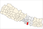
Dharmanagar is a village and Village Development Committee in Bara District in the Narayani Zone of south-eastern Nepal. At the time of the 2011 Nepal census it had a population of 5,357 persons living in 770 individual households. There were 2,786 males and 2,571 females at the time of census.
South Jhitakaiya is a town and Village Development Committee, near by Dewapur- Chowk/Pokhara/Mandir/School/Police Station and Pashah River, Bara District in the Narayani Zone of south-eastern Nepal. At the time of the 1991 Nepal census it had a population of 7,235.
Kabhre is a town and Village Development Committee in Dang Deokhuri District in the Rapti Zone of south-western Nepal. At the time of the 1991 Nepal census it had a population of 6,033 persons residing in 1142 individual households.
Damarkhu Shivalaya is a town and Village Development Committee in Khotang District in the Sagarmatha Zone of eastern Nepal. At the time of the 1991 Nepal census it had a population of 3,237 persons living in 602 individual households.
Lichki Ramche is a village and Village Development Committee in Khotang District in the Sagarmatha Zone of eastern Nepal. At the time of the 1991 Nepal census it had a population of 3,363 persons living in 606 individual households.
Bhorle is a Village Development Committee in Rasuwa District in the Bagmati Zone of northern Nepal. At the time of the 1991 Nepal census it had a population of 4884 people residing in 903 individual households.
Laharepauwa is a village development committee in Rasuwa District in the Bagmati Zone of northern Nepal. At the time of the 1991 Nepal census it had a population of 4276 people living in 774 individual households.
Gagal Bhadaure, Janakpur is a village development committee in Ramechhap District in the Janakpur Zone of north-eastern Nepal. At the time of the 1991 Nepal census it had a population of 2596 people living in 468 individual households.
Bagahi is a Village Development Committee in Rautahat District in the Narayani Zone of south-eastern Nepal. At the time of the 1991 Nepal census it had a population of 2217 people residing in 429 individual households.
Birtiprastoka is a village development committee in Rautahat District in the Narayani Zone of south-eastern Nepal. At the time of the 1991 Nepal census it had a population of 2492 people living in 478 individual households.
Dumriya is a town and market center in Chandrapur Municipality in Rautahat District in the Narayani Zone of south-eastern Nepal. The formerly village development committee was merged to form the municipality on 18 May 2014. At the time of the 1991 Nepal census it had a population of 12,993.
Raghunathpur is a village development committee in Rautahat District in the Narayani Zone of south-eastern Nepal. At the time of the 1991 Nepal census it had a population of 3484 people living in 673 individual households.
Santpur is a town and market center in Chandrapur Municipality in Rautahat District in the Narayani Zone of south-eastern Nepal. The formerly village development committee was merged to form the municipality on 18 May 2014. At the time of the 1991 Nepal census it had a population of 5594.