Siraha is the headquarters and municipality of Siraha District, a part of Sagarmatha Zone, Nepal. Siraha had a population of 28,442 according to the census of 2011. and a population of 82,531 as of 2015. The mayor ois Asheswor Yadava and the deputy mayor is Dr. Namita Yadav. Both assumed office on 25 September 2017. The town is at 80 metres (260 ft) altitude, 29 kilometres (18 mi) ESE of Janakpur.

Solududhkunda (earlier:Dudhkunda) is the only municipality of Solukhumbu District. Located in Province No. 1 of Nepal. The town of Salleri, which is located within the municipality is the headquarter of Solukhumbu District It was formed in 2014 by merging four VDCs: Salleri, Garma, Loding Tamakhani and Beni and was divided into 9 wards. Total area of the municipality had 254.3 square kilometres (98.2 sq mi) and population of municipality had 20,399 individuals living in 5,368 households.

Bahrabise is a city in Sindhupalchok District in the Bagmati Zone of central Nepal. It consists of nine wards.
Phulpingkot is a village in Sindhupalchok District in the Bagmati Zone of central Nepal. At the time of the 1991 Nepal census it had a population of 3714 and had 773 houses in the village. It has been divided into 9 wards. This VDC is attached to a famous marketplace in Sindhupalchok called Jalbire. People in this district have different ethnicity and religions. The neighboring VDCs are Jalbire, Hagam, Phulpingdada, Maneshwara and Bataase. People are involved in agriculture for living. Almost all of the people are in below poverty line. Many have been working in foreign soil for the survival of their family. Famous poet of Sindhupalchok District, Chandra Prasad Neupane is from this VDC.
Listikot is a village in Sindhupalchok District in the Bagmati Zone of central Nepal. At the time of the 1991 Nepal census it had a population of 3664 and had 714 houses in the village.
Dilasaini is a former village development committee that is now a Rural Municipality in Baitadi District in Province No. 7 of western Nepal. At the time of the 1991 Nepal census it had a population of 4,828 and had 849 houses in the village. There is one plus two, two high schools and many primary schools in the VDC. This VDC is bordered by Mathairaj, Gokuleshwor, Rudreswor and Rim VDC and Darchula district in the northwest. Ths VDC is named after a local deity. The temple of this devi is located in Dhamigaun which is one of the wards of the VDC. This temple is famous in far-western Nepal for the sacrifice of huge number of bull buffaloes on occasion of Dashain.
Bungkot is a village development committee in Gorkha District in the Gandaki Zone of northern-central Nepal. At the time of the 1991 Nepal census it had a population of 6,599, and there were 1,214 houses in the town.

Takukot is a Ward of Barpak sulikot Rural Municipality in Gorkha District in the Gandaki Province of northern-central Nepal. At the time of the 1991 Nepal census it had a population of 4,234 and had 801 houses in the town.
Lamatar is a village and former Village Development Committee that is now part of Mahalaxmi Municipality in Province No. 3 of central Nepal.
Dhikurpokhari is a suburb and Village Development Committee in Kaski District in the Gandaki Zone of northern-central Nepal. At the time of the 1991 Nepal census it had a population of 7,392 persons living in 1,427 individual households.

Bajung is a village development committee in Parbat District in the Dhawalagiri Zone of Western Development Region, Nepal.It is surrounded by Deupurkot in the north-east, Tilahar in south-east, Durlung in South-west and Kyang in North-west. It is popularly said to be extended from the top of Maidan, a hill-top with historical identity to the basin of Modi River. At the time of the 2011 Nepal census it had a population of 4228 people living in 1,076 individual households.
Chapakot is a municipality in the southeastern part of Syangja District in the Province No. 4 of central Nepal. The new municipality was formed by merging three existing villages—Ratnapur, Kuwakot and Chapakot—on 18 May 2014. In 12 March, 2017 The government implemented the new local administrative structure consisting of 744 local units. With the implementation of this new local administrative structure, the old structure will no longer be in existence. According to the new structure, VDCs will be replaced with village councils. Newly merged VDCs are Sankhar, Sekham, Ward no. 8 of Pakbadi & Ward no. of Malengkot. The office of the municipality is that of the former Chapakot Municipality.
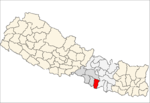
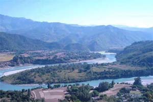
Purkot is a village development committee in Tanahu District in the Gandaki Zone of central Nepal. At the time of the 2011 Nepal census it had a population of 7,188! among them 3,044(male) 4,144(female). This VDC is located on the highway called vanu highway(Dumre-besishahar) and has a small town called Baishjangar where Police station, health posts, schools and some other major facilities available.This village is somehow called as a transit for another neighboring districts Lamjung and Gorkha. Well famous river Marshyandi flows through this place. The village consists of various casts of people such as major Brahman Tamang-Gurung including, Newar, and Chettris etc. and equally celebrates their festivals each other.Purkot:The main income sources for the VDC is remittance as well Agriculture and small business. ward number: 1-9 Baishjangar which is main city(bazar). Police station and school: ward no. 5 in Kharpani. Purkot has some major high school in the town which are Shree Kalika multiple campus and Karmada secondary school. b
Ranigunj is a village development committee in Sarlahi District in the Janakpur Zone of south-eastern Nepal. At the time of the 1991 Nepal census it had a population of 4192 people living in 767 individual households.

Pakhribas is an urban municipality out of three urban municipalities located in Dhankuta District of Province No. 1 of Nepal. Pakhribas municipality established on 2 December 2014 merging following VDCs: Pakhribas, Sanne, Phalate, Ghortikharka and Muga.
Jhalariझलारी is a Village Development Committee in Kanchanpur District in the Mahakali Zone of South-Far-Western Nepal. At the time of the 1991 Nepal census it had a population of 10,590 people living in 1702 individual households.
Chitlang ) is a VDC located in Makwanpur District, Narayani Zone, CDR, Nepal.
Jahada is a village development committee in Nawalparasi District in the Lumbini Zone of southern Nepal. At the time of the 1991 Nepal census it had a population of 6532 people living in 1110 individual households.It has 9 ward numbers. Unity in diversity is mostly followed in this VDC.VDC office is located in vatulliya beside the jahada community liabery.
Naya Belhani is a village development committee in Nawalparasi District in the Lumbini Zone of western Nepal. At the time of the 1991 Nepal census it had a population of 9786 people living in 1795 individual households. Naya Belhani is divided into 9 wards, among which ward number 9, Arunkhola is the center of the VDC, which is considered one of an emerging business market of the Nawalparasi district. The VDC's main interesting factor is divided into two parts by Aarungkhola river and East West highway. The river is partition 6, 7 & 9 ward east region and 1,2,3,4,5,8 west region.