
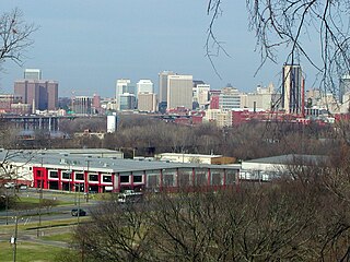
Richmond is the capital city of the Commonwealth of Virginia in the United States. Incorporated in 1742, Richmond has been an independent city since 1871. The city's population in the 2020 census was 226,610, up from 204,214 in 2010, making it Virginia's fourth-most populous city. The Richmond metropolitan area, with over 1.3 million residents, is the Commonwealth's third-most populous.

Goochland County is a county located in the Piedmont of the Commonwealth of Virginia. Its southern border is formed by the James River. As of the 2020 census, the population was 24,727. Its county seat is Goochland.

Highland Springs is a census-designated place (CDP) located in Henrico County, Virginia, United States, 4.3 miles (7 km) east of Richmond. The population was 16,604 at the 2020 census.

The West End is a part of Richmond, Virginia. Definitions of the bounds of the West End vary, it may include only the western part of the city of Richmond or extend as far as western Henrico County. As there is no one municipal organization that represents this specific region, the boundaries are loosely defined as being north of the James River, west of I-195, and south of Broad Street. Historically, the Richmond neighborhoods of the Fan and the Museum District were a part of the West End. A primary conduit through the West End is Interstate 64.

Broad Street is a 15-mile-long (24 km) road located in the independent city of Richmond, Virginia, and adjacent Henrico County. Broad Street is significant to Richmond due to the many commercial establishments that have been built along it throughout Richmond's history. From downtown through miles into the suburbs, the street is largely dedicated to retailing and offices, including regional and neighborhood shopping centers and malls.
The Greater Richmond, Virginia area has many neighborhoods and districts.

State Route 147 is a primary state highway in the U.S. state of Virginia. The state highway runs 13.13 miles (21.13 km) from U.S. Route 60 in Midlothian east to US 60 in Richmond. In various places, it is known as Huguenot Road, River Road, Cary Street Road and Main Street. SR 147 connects Midlothian with the West End of Richmond via the Huguenot Memorial Bridge across the James River. Within Richmond, the state highway follows Cary Street, a major thoroughfare that connects the city's two major universities, the University of Richmond and Virginia Commonwealth University, with Downtown Richmond.

Huguenot Memorial Bridge is located in Henrico County and the independent city of Richmond, Virginia. It carries State Route 147 across the former Chesapeake and Ohio Railway, the James River and Kanawha Canal, and the James River in the Fall Line region above the head of navigation at Richmond.

Westham Bridge crossed the James River between Henrico County and Chesterfield County. The bridge was located between Bosher Dam and Williams Island Dam just west of the 7 miles of rapids and falls which constitute the fall line of the James River at Richmond, Virginia.

The Henrico County Public Schools school system is a Virginia school division that operates as an independent branch of the Henrico County, Virginia county government and administers public schools in the county. Henrico County Public Schools has five International Baccalaureate schools – John Randolph Tucker High School, Henrico High School, Fairfield Middle School, Tuckahoe Middle School and George H. Moody Middle School.

Shockoe Hill is one of several hills on which much of the oldest portion of the City of Richmond, Virginia, U.S., was built. It extends from the downtown area, including where the Virginia State Capitol complex sits, north almost a mile to a point where the hill falls off sharply to the winding path of Shockoe Creek. Interstate 95 now bisects the hill, separating the highly urbanized downtown portion from the more residential northern portion.
Fulton Hill is a neighborhood located in the East End of Richmond, Virginia. The name is used for the area stretching from Gillies Creek to the Richmond city limits. The Greater Fulton Hill Civic Association includes Fulton Bottom, part of Montrose Heights and part of Rocketts. Fulton Hill is south of Church Hill and Shockoe Bottom, north of Varina, east of the James River, and west of Sandston. The zip code is 23231.

U.S. Route 301 is a part of the U.S. Highway System that runs from Sarasota, Florida, to Biddles Corner, Delaware. In Virginia, the U.S. Highway runs 142.70 miles (229.65 km) from the North Carolina state line near Skippers north to the Maryland state line at the Potomac River near Dahlgren. US 301 forms the local complement to Interstate 95 (I-95) from Emporia to Petersburg. The U.S. Highway runs concurrently with US 1 between Petersburg and the state capital of Richmond, where the highways form one of the main north–south avenues. US 301 continues north concurrent with Virginia State Route 2 to Bowling Green, forming an eastern alternative to I-95 and US 1 north of Richmond. At Bowling Green, which is connected to I-95 by SR 207, US 301 becomes the primary highway connecting Richmond and the Northern Neck with Southern Maryland. US 301 was constructed in four main segments: as the original SR 24 and then US 17-1 south of Petersburg, as US 1 from Petersburg to Richmond, as SR 2 from Richmond to Bowling Green, and as part of SR 207 toward Dahlgren. US 301 replaced US 17–1 in the early 1930s and was extended from Petersburg north along its current course into Maryland when the Potomac River Bridge was completed in 1940.

U.S. Route 60 (US 60) in the Commonwealth of Virginia runs 303 miles (488 km) west to east through the central part of the state, generally close to and paralleling the Interstate 64 corridor, except for the crossing of the Blue Ridge Mountains, and in the South Hampton Roads area.
State Route 197 is a primary state highway in the U.S. state of Virginia. The state highway runs 3.60 miles (5.79 km) from SR 147 in Richmond east to U.S. Route 1 and US 301 in Richmond.
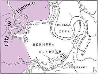
The City of Henrico is one of the oldest counties in the Colony of Virginia. It was one of four incorporations established in the colony by its proprietor, the Virginia Company. The City of Henrico, which included the settlement of Henricus, was the furthest incorporation upstream on the James River. In 1634, Henrico was reorganized under royal authority as the shire of Henrico, one of eight shires in the Crown Colony of Virginia, Later, it became known as Henrico County, Virginia.
The East End of Richmond, Virginia is the quadrant of the City of Richmond, Virginia, and more loosely the Richmond metropolitan area, east of the downtown.
U.S. Route 250 is a part of the U.S. Highway System that runs from Sandusky, Ohio to Richmond, Virginia. In Virginia, the highway runs 166.74 miles (268.34 km) from the West Virginia state line near Hightown east to its eastern terminus at US 360 in Richmond. US 250 is the main east–west highway of Highland County, which is known as Virginia's Little Switzerland; the highway follows the path of the 19th century Staunton and Parkersburg Turnpike. From Staunton east to Richmond, the highway serves as the local complement to Interstate 64 (I-64), roughly following the 18th century Three Notch'd Road through Waynesboro and Charlottesville on its way through the Shenandoah Valley, its crossing of the Blue Ridge Mountains at Rockfish Gap, and the Piedmont. In the Richmond metropolitan area, US 250 is known as Broad Street, a major thoroughfare through the city's West End and downtown areas.
Creighton Court is a neighborhood in Richmond, Virginia's East End region. Creighton Court sits on the border between the City of Richmond and eastern Henrico County. The neighborhood is situated directly north of the Oakwood Cemetery and alongside the interchange of Virginia Route 33 and Interstate 64. North 29th Street and Creighton Road serve as the main arteries of the community. Richmond Redevelopment and Housing Authority redeveloped the housing into mixed-income units in 2022.
Green Park is a small neighborhood of approximately 240 homes located in Richmond, Virginia, United States. The neighborhood is within the boundaries of the North Side of the city limits.
