
Oregon Hill is a historic working-class neighborhood in Richmond, Virginia. Oregon Hill overlooks the James River and Belle Isle, and provides access to Hollywood Cemetery. Due to the neighborhood's proximity to the Monroe Park Campus of Virginia Commonwealth University, the neighborhood is sometimes referred to as a student quarter because of its high college student population.

Ginter Park is a suburban neighborhood of Richmond, Virginia built on land owned and developed by Lewis Ginter. The neighborhood's first well known resident was newspaperman Joseph Bryan, who lived in Laburnum, first built in 1883 and later rebuilt. In 1895, many acres of land north of Richmond were purchased by Ginter in order to develop into neighborhoods. Ginter Park and other neighborhoods were developed from this initial land purchase. In Ginter Park are Union Presbyterian Seminary and as well as Pollard Park.

The history of Richmond, Virginia, as a modern city, dates to the early 17th century, and is crucial to the development of the colony of Virginia, the American Revolutionary War, and the Civil War. After Reconstruction, Richmond's location at the falls of the James River helped it develop a diversified economy and become a land transportation hub.
The Greater Richmond, Virginia area has many neighborhoods and districts.
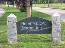
Hermitage Road Historic District (HRHD) is a Northside neighborhood in the independent city of Richmond, Virginia. The district is a Richmond Old and Historic District, as well as being listed on the Virginia Landmarks Register and the National Register of Historic Places.

Originally a trolley car suburb in the years just before the dawn of the 20th century, the Fairmount neighborhood in Church Hill, Richmond, Virginia, is located just north of Union Hill. Much of the neighborhood was developed from the 1890s to the 1920s, and its buildings largely reflect Queen Anne, Italianate, and 1920s bungalow architecture. What is likely the oldest remaining residence, a frame house, probably dates from before 1870. A notable property in the Fairmount neighborhood is the Fairmount School. Annexed from Henrico County in 1906, Fairmount was first incorporated as an independent town on March 10, 1902.

Shockoe Bottom, historically known as Shockoe Valley, is an area in Richmond, Virginia, just east of downtown, along the James River. Located between Shockoe Hill and Church Hill, Shockoe Bottom contains much of the land included in Colonel William Mayo's 1737 plan of Richmond, making it one of the city's oldest neighborhoods.

Shockoe Slip is a district in the downtown area of Richmond, Virginia. The name "slip" referred to a narrow passageway leading from Main Street to where goods were loaded and unloaded from the former James River and Kanawha Canal. The rough boundaries of Shockoe Slip include 14th Street, Main Street, Canal Street and 12th Street.
Court End is a neighborhood in Richmond, Virginia, that sits to the north of the Capitol Square and East Broad Street. It developed in the Federal era, after Virginia's capital moved from Williamsburg.

The Chestnut Hill–Plateau Historic District is a historic area in the Highland Park neighborhood of Richmond, Virginia. It is also known as 'Highland Park Southern Tip' on city neighborhood maps.

Ashton Heights Historic District is a national historic district located in Arlington County, Virginia. Today, the Ashton Height Historic District contains 1,097 contributing buildings, one contributing site, and one contributing structure in a residential neighborhood in North Arlington.

The Arlington Heights Historic District is a national historic district located at Arlington County, Virginia. It contains 737 contributing buildings and 1 contributing site in a residential neighborhood in central Arlington. The area was formed from the integration of 25 subdivisions platted between 1909 and 1978. Single-family dwellings include representative examples of the Tudor Revival and Colonial Revival styles.

The Riverview Historic District is a national historic district located at Norfolk, Virginia. It encompasses 200 contributing buildings in a primarily residential section of Norfolk. It developed primarily during the first quarter of the 20th century, as a suburban community north of the growing downtown area of Norfolk. The neighborhood includes notable examples of a variety of Late Victorian and Late 19th And 20th Century Revival styles.

The Carver Industrial Historic District is a national historic district located at Carver, Richmond, Virginia. The district encompasses 13 contributing buildings located west of downtown Richmond. The industrial area developed between 1890 and 1930, along the tracks of the Richmond, Fredericksburg and Potomac Railroad. The buildings are in a variety of popular 19th-century and early 20th century architectural styles including Queen Anne and Romanesque.

The Laburnum Park Historic District is a national historic district located at Richmond, Virginia. The district encompasses 226 contributing buildings and 2 contributing structures located north of downtown Richmond. The primarily residential area developed starting in the early-20th century as one of the city's early "streetcar suburbs" and as home to several important local institutions. The buildings are in a variety of popular early-20th century architectural styles including Queen Anne and Colonial Revival. It was developed as neighborhood of middle-to-upper-class, single-family dwellings. Notable buildings include the Laburnum House (1908), Richmond Memorial Hospital (1954–1957), Richmond Memorial Hospital Nursing School (1960–1961), "The Hermitage" (1911), Laburnum Court (1919), Veritas School.

The Brookland Park Historic District is a national historic district located at Richmond, Virginia. The district encompasses 1,157 contributing buildings located north of downtown Richmond and Barton Heights.
The Battery Court Historic District is a national historic district located at Richmond, Virginia. The district encompasses 549 contributing buildings and 1 contributing site located north of downtown Richmond and west of Barton Heights and Brookland Park. The primarily residential area developed starting in the early-20th century as one of the city's early “streetcar suburbs.” The buildings are in a variety of popular late-19th and early-20th century architectural styles including frame bungalows, American Foursquare, Colonial Revival, Tudor Revival, and Mission Revival. Notable non-residential buildings include the Overbrook Presbyterian Church and Battery Park Christian Church.

The Highland Park Plaza Historic District is a national historic district located at Highland Park, Richmond, Virginia. The district encompasses 1,005 contributing buildings located north of downtown Richmond and east of Barton Heights and Brookland Park. The primarily residential area developed starting in the late-19th century as one of the city's early "streetcar suburbs." It was added to the National Register of Historic Places in 2004.

The Main Street Banking Historic District is a national historic district located in downtown Richmond, Virginia. The district encompasses 19 contributing buildings located south of the Virginia State Capitol and west of the Shockoe Slip Historic District. It is the location of a number of buildings built for or occupied by banking institutions. The district includes representative examples of the Late Victorian and International Style architecture built between about 1865 and 1965. Notable buildings include the Virginia Employment Commission Building (1960), the 700 Building (1964), the Ross Building (1964), the Fidelity Building (1965). Located in the district is the separately listed First National Bank Building.
Shockoe Valley is an area in Richmond, Virginia, just east of downtown, along the James River, and is the entertainment center of the city. Located between Shockoe Hill and Church Hill, Shockoe Valley contains much of the land included in Colonel William Mayo's 1737 plan of Richmond, making it one of the city's oldest neighborhoods. Shockoe Valley encompasses the smaller neighborhoods of Shockoe Slip, Shockoe Bottom and Tobacco Row along Cary Street.


