West End (Richmond, Virginia)

Last updated
The West End
Neighborhood
USA Virginia location map.svg
Red pog.svg
The West End
Location within the state of Virginia
Coordinates: 37°37′16″N77°33′30″W / 37.62111°N 77.55833°W / 37.62111; -77.55833
Country United States
State Virginia
Independent city Richmond
Time zone UTC-5 (Eastern (EST))
  Summer (DST) UTC-4 (EDT)
Richmond is often subdivided into North Side, Southside, East End and West End RichmondNSEW.png
Richmond is often subdivided into North Side, Southside, East End and West End

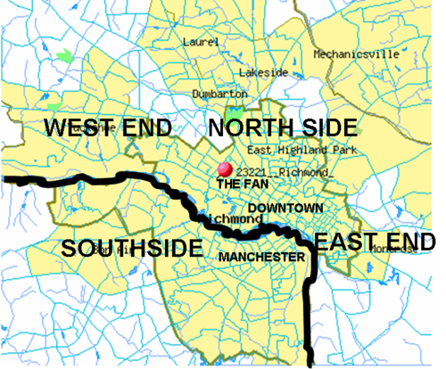
The West End is a part of Richmond, Virginia. Definitions of the bounds of the West End vary, it may include only the western part of the city of Richmond or extend as far as western Henrico County. As there is no one municipal organization that represents this specific region, the boundaries are loosely defined as being north of the James River, west of I-195, and south of Broad Street. Historically, the Richmond neighborhoods of the Fan and the Museum District were a part of the West End. A primary conduit through the West End is Interstate 64.

Contents

Geographic description

This section is arranged by exits off Interstate 64. In previous decades, the term "The West End" generally referred to the western area of the city itself. However, in recent years, the urbanized area has expanded residentially and commercially into Henrico County, and new developments in the western portion of the city and county in combination are now also considered to be part of "The West End."

A common tool of differentiation used locally is to refer to the westernmost part (generally beginning at the Richmond-Henrico Line going west to Short Pump) as "The Far West End," and to refer to the section closer to and within the city limits as "The Near West End" or "Westhampton."

In addition to Richmond, Virginia addresses, the West End includes the census-designated places of part of Glen Allen, and all of Short Pump, Tuckahoe, and Wyndham.

Staples Mill Road, Willow Lawn, and Westhampton

Broad and Glenside

Parham Road

Gaskins Road and Innsbrook

Short Pump

I-295 and Nuckols Road

Parks and recreation

Education

Elementary schools

Dumbarton Elementary Schools

Middle schools

High schools

Private and parochial schools

Colleges and universities

Culture

Museums

Theater and entertainment

Commerce

The principal non-interstate east-west commercial corridors are located along Broad Street (U.S. Highway 250) and Patterson Avenue (State Route 6) each of which extends from the Richmond City Limits westerly through Henrico County into Goochland County. There are many restaurants, businesses and shopping centers, mostly located along or near the three major thoroughfares (Broad Street road and Patterson Avenue runs east-west, Parham runs north-south ). Several major clusters include:

Industry

Other

Related Research Articles

<span class="mw-page-title-main">Henrico County, Virginia</span> County in Virginia, United States

Henrico County, officially the County of Henrico, is located in the Commonwealth of Virginia in the United States. As of the 2020 census, the population was 334,389 making it the fifth-most populous county in Virginia. Henrico County is included in the Greater Richmond Region. There is no incorporated community within Henrico County; therefore, there is no incorporated county seat either. Laurel, an unincorporated CDP, serves this function.

<span class="mw-page-title-main">Goochland County, Virginia</span> County in Virginia, United States

Goochland County is a county located in the Piedmont of the Commonwealth of Virginia. Its southern border is formed by the James River. As of the 2020 census, the population was 24,727. Its county seat is Goochland.

Short Pump is a census-designated place (CDP) in Henrico County, Virginia, United States. It is a suburb of Richmond, Virginia. The population was 30,626 at the 2020 census.

<span class="mw-page-title-main">Greater Richmond Transit Company</span>

The Greater Richmond Transit Company, known locally as GRTC, is a local government-owned public service company which operates an urban-suburban bus line based in Richmond, Virginia. In 2022, the system had a ridership of 8,739,400, or about 29,600 per weekday as of the first quarter of 2023.

<span class="mw-page-title-main">Broad Street (Richmond, Virginia)</span> United States historic place

Broad Street is a 15-mile-long (24 km) road located in the independent city of Richmond, Virginia, and adjacent Henrico County. Broad Street is significant to Richmond due to the many commercial establishments that have been built along it throughout Richmond's history. From downtown through miles into the suburbs, the street is largely dedicated to retailing and offices, including regional and neighborhood shopping centers and malls.

The Greater Richmond, Virginia area has many neighborhoods and districts.

<span class="mw-page-title-main">Interstate 195 (Virginia)</span> Highway in Virginia

Interstate 195 (I-195) is an auxiliary Interstate Highway in the US state of Virginia. Known as the Beltline Expressway, the highway runs 3.24 miles (5.21 km) from State Route 195 (SR 195), a toll road that continues south into Downtown Richmond, north to I-64 and I-95 on the northern edge of Richmond. I-195 passes through the West End of Richmond and connects I-64 and I-95 with US Route 33 (US 33) and US 250, which follow Broad Street, and with SR 76, a toll road that links Richmond with the Southside of the metropolitan area.

<span class="mw-page-title-main">Virginia State Route 150</span> State highway in Virginia, United States

State Route 150 is a state highway in the U.S. state of Virginia. Known as Chippenham Parkway, the state highway runs 15.19 miles (24.45 km) from Interstate 95 (I-95) and SR 895 in Bensley north to Parham Road and River Road near Tuckahoe in Henrico County. SR 150 is a four- to six-lane circumferential highway that connects the Chesterfield County suburbs of Richmond with western Henrico County and, via SR 895, eastern Henrico County and Richmond International Airport. The highway is a freeway except for a short stretch east of SR 147 in Richmond. SR 150 has junctions with all of the radial highways south of the James River, including I-95, U.S. Route 1, US 301, US 360, US 60, and SR 76.

<span class="mw-page-title-main">Virginia State Route 6</span>

State Route 6 is a primary state highway in the U.S. state of Virginia. Known for most of its length as River Road, the state highway runs 102.26 miles (164.57 km) from U.S. Route 250 in Afton east to SR 161 in Richmond. SR 6 is one of the main highways of mountainous Nelson County, where the highway runs north–south from its beginning to US 29. From Scottsville to Richmond, the state highway parallels the James River. SR 6 is a major suburban highway through southwestern Henrico County and the main street of Richmond's West End.

<span class="mw-page-title-main">Virginia State Route 161</span> Highway in Richmond, Virginia, United States

State Route 161 is a primary state highway in and near Richmond, Virginia, United States. It extends from an interchange with Interstate 95 (I-95) in the independent city of Richmond north to an intersection with U.S. Route 1 in the Lakeside area of central Henrico County.

<span class="mw-page-title-main">Henrico County Public Schools</span>

The Henrico County Public Schools school system is a Virginia school division that operates as an independent branch of the Henrico County, Virginia county government and administers public schools in the county. Henrico County Public Schools has five International Baccalaureate schools – John Randolph Tucker High School, Henrico High School, Fairfield Middle School, Tuckahoe Middle School and George H. Moody Middle School.

<span class="mw-page-title-main">Short Pump Town Center</span> Shopping mall in Virginia, United States

Short Pump Town Center is an open-air shopping mall located in the Short Pump census-designated place (CDP) of unincorporated Henrico County, Virginia on West Broad Street, approximately 1 mile (1.6 km) west of I-64, exit 178A/B. This area of Henrico County is called The West End and is northwest of Richmond. Short Pump Town Center is home to many restaurants and stores including Macy's and Dillard's.

<span class="mw-page-title-main">U.S. Route 33 in Virginia</span> Section of US highway in Virginia

U.S. Route 33 is a part of the U.S. Highway System that runs from Elkhart, Indiana to Richmond, Virginia. In Virginia, the U.S. Highway runs 135.60 miles (218.23 km) from the West Virginia state line near Rawley Springs east to its eastern terminus at SR 33 in Richmond. US 33 is the primary east–west highway of Rockingham County, which lies in the Shenandoah Valley. The highway connects the independent city of Harrisonburg, the town of Elkton, and an entrance to Shenandoah National Park. East of the Blue Ridge Mountains, US 33 connects the Piedmont communities of Stanardsville, Gordonsville, and Louisa. The U.S. Highway is a major suburban and urban route in the Richmond metropolitan area. Within Richmond, US 33 runs concurrently with US 250. SR 33 continues from US 33's eastern terminus as a state-numbered extension of the U.S. Highway that connects Richmond with Virginia's Middle Peninsula.

<span class="mw-page-title-main">Virginia State Route 157</span>

State Route 157 is a primary state highway in the U.S. state of Virginia. The state highway runs 7.71 miles (12.41 km) from SR 6 in Tuckahoe north to U.S. Route 33 in Glen Allen. SR 157 passes through western Henrico County, a suburban area north and west of Richmond.

<span class="mw-page-title-main">Virginia State Route 197</span> Highway in Virginia

State Route 197 is a primary state highway in the U.S. state of Virginia. The state highway runs 3.60 miles (5.79 km) from SR 147 in Richmond east to U.S. Route 1 and US 301 in Richmond.

<span class="mw-page-title-main">U.S. Route 250 in Virginia</span>

U.S. Route 250 is a part of the U.S. Highway System that runs from Sandusky, Ohio to Richmond, Virginia. In Virginia, the highway runs 166.74 miles (268.34 km) from the West Virginia state line near Hightown east to its eastern terminus at US 360 in Richmond. US 250 is the main east–west highway of Highland County, which is known as Virginia's Little Switzerland; the highway follows the path of the 19th century Staunton and Parkersburg Turnpike. From Staunton east to Richmond, the highway serves as the local complement to Interstate 64 (I-64), roughly following the 18th century Three Notch'd Road through Waynesboro and Charlottesville on its way through the Shenandoah Valley, its crossing of the Blue Ridge Mountains at Rockfish Gap, and the Piedmont. In the Richmond metropolitan area, US 250 is known as Broad Street, a major thoroughfare through the city's West End and downtown areas.

Church Run is a residential neighborhood in Henrico County, Virginia that was built at the beginning of the 1990s. Church Run can be accessed by two entry points: one entry point is off of Church Road, and one is off of Three Chopt Road, between Cox Rd. and John Rolfe Pkwy.

<span class="mw-page-title-main">Three Notch'd Road</span> Colonial-era route across Virginia

Three Notch'd Road was a colonial-era major east-west route across central Virginia. It is believed to have taken its name from a distinctive marking of three notches cut into trees to blaze the trail. By the 1730s, the trail extended from the vicinity of the fall line of the James River at the future site of Richmond westerly to the Shenandoah Valley, crossing the Blue Ridge Mountains at Jarmans Gap. In modern times, a large portion of U.S. Route 250 in Virginia follows the historic path of the Three Notch'd Road, as does nearby Interstate 64.

Parham Road is a circumferential highway in Henrico County in the U.S. state of Virginia. The highway runs 12.08 miles (19.44 km) from Virginia State Route 150 near Tuckahoe east to U.S. Route 301 and SR 2 in Chamberlayne. Parham Road serves the northwestern suburbs of Richmond, including Tuckahoe, Laurel, and Chamberlayne. The four-lane divided highway intersects all of the major highways that extend northwest and north from the city, including Interstate 64 (I-64) and I-95. Parham Road is county maintained except for the portion that is State Route 73, a connector between US 1 and I-95. The Parham Road name was applied to a small portion of the current route by the early 20th century. SR 73 was constructed in the early 1960s. Most of Parham Road from SR 6 to US 1 was constructed as a new four-lane divided highway by Henrico County in the late 1960s; the existing sections were upgraded at the same time. The highway was extended east to its present terminus in the late 1970s. Parham Road was completed south to its present western terminus in 1990 concurrent with the extension of SR 150 across the James River from the Southside of Richmond to Henrico County.

Henrico County Public Library system serves the county of Henrico, Virginia. The library system is within Region 4 of the Virginia Library Association (VLA). Henrico County Public Library System has eleven locations. The library branches house over 600 computers for public usage.