Church Hill, also known as the St. John's Church Historic District, is an Old and Historic District in Richmond, Virginia. This district encompasses the original land plat of the city of Richmond. Church Hill is the eastern terminus of Broad Street, a major east-west thoroughfare in the Richmond metropolitan area. The name Church Hill is often used to describe both the specific historic district and the larger general area in the East End encompassing other neighborhoods such as Union Hill, Chimborazo, Fairmount, Peter Paul, Woodville, etc.

Monument Avenue is a tree-lined grassy mall dividing the eastbound and westbound traffic in Richmond, Virginia, originally named for its emblematic complex of structures honoring those who fought for the Confederacy during the American Civil War. Between 1900 and 1925, Monument Avenue greatly expanded with architecturally significant houses, churches, and apartment buildings. Four of the bronze statues representing J. E. B. Stuart, Stonewall Jackson, Jefferson Davis and Matthew Fontaine Maury were removed from their memorial pedestals amidst civil unrest in July 2020. The Robert E. Lee monument was handled differently as it was owned by the Commonwealth, in contrast with the other monuments which were owned by the city. Dedicated in 1890, it was removed on September 8, 2021. All these monuments, including their pedestals, have now been removed completely from the Avenue. The last remaining statue on Monument Avenue is the Arthur Ashe Monument, memorializing the African-American tennis champion, dedicated in 1996.

The Fan is a district of Richmond, Virginia, so named because of the "fan" shape of the array of streets that extend west from Belvidere Street, on the eastern edge of Monroe Park, westward to Arthur Ashe Boulevard. However, the streets rapidly resemble a grid after they go through what is now Virginia Commonwealth University. The Fan is one of the easterly points of the city's West End section, and is bordered to the north by Broad Street and to the south by VA 195, although the Fan District Association considers the southern border to be the properties abutting the south side of Main Street. The western side is sometimes called the Upper Fan and the eastern side the Lower Fan, though confusingly the Uptown district is located near VCU in the Lower Fan. Many cafes and locally owned restaurants are located here, as well as historic Monument Avenue, a boulevard formerly featuring statuary of the Civil War's Confederate president and generals. The only current statue is a more modern one of tennis icon Arthur Ashe. Development of the Fan district was strongly influenced by the City Beautiful movement of the late 19th century.

Broad Street is a 15-mile-long (24 km) road located in the independent city of Richmond, Virginia, and adjacent Henrico County. Broad Street is significant to Richmond due to the many commercial establishments that have been built along it throughout Richmond's history. From downtown through miles into the suburbs, the street is largely dedicated to retailing and offices, including regional and neighborhood shopping centers and malls.
The Greater Richmond, Virginia area has many neighborhoods and districts.

Wynnefield is a diverse middle-class neighborhood in West Philadelphia. Its borders are 53rd Street at Jefferson to the south, Philadelphia's Fairmount Park to the east, City Avenue to the north and the Amtrak Philadelphia Main Line tracks to the west.

Kensington is a neighborhood in Philadelphia that belongs to Lower Northeast. As with all neighborhoods in the city, the lack of any official designation means the boundaries of the area vary between sources over time and are disputed among locals. Kensington, as most long-term residents view it, refers generally to the area consisting of Kensington, East Kensington, West Kensington, and Harrowgate. The adjacent Fairhill and Norris Square neighborhoods are more separate but may be included in Kensington; Fishtown and South (Olde) Kensington were historically included. The most conservative boundaries of the neighborhood, shown in the map below, are Front Street and 5th Street to the west, the Amtrak train tracks to the North, Trenton Avenue, the Trenton Avenue train tracks, and Frankford Avenue to the east, and Cecil B. Moore Avenue to the south.

State Route 33 is a primary state highway in the U.S. state of Virginia. The state highway runs 72.23 miles (116.24 km) from U.S. Route 33 and US 250 in Richmond, Virginia east to Chesapeake Boulevard in Stingray Point. SR 33 is a state-numbered eastward extension of US 33 that connects Richmond with West Point and the Middle Peninsula, one of three large peninsulas on the west side of the Chesapeake Bay in Virginia. The state highway is a major thoroughfare in the downtown and East End areas of Richmond. SR 33 serves a suburban area in eastern Henrico County before running concurrently with US 60, Interstate 64 (I-64), and SR 30 east toward West Point. The state highway heads from West Point through Saluda, east of which SR 33 serves as the main highway of Middlesex County.

State Route 147 is a primary state highway in the U.S. state of Virginia. The state highway runs 13.13 miles (21.13 km) from U.S. Route 60 in Midlothian east to US 60 in Richmond. In various places, it is known as Huguenot Road, River Road, Cary Street Road and Main Street. SR 147 connects Midlothian with the West End of Richmond via the Huguenot Memorial Bridge across the James River. Within Richmond, the state highway follows Cary Street, a major thoroughfare that connects the city's two major universities, the University of Richmond and Virginia Commonwealth University, with Downtown Richmond.

Jackson Ward, previously known as Central Wards, is a historically African-American district in Richmond, Virginia, with a long tradition of African-American businesses. It is located less than a mile from the Virginia State Capitol, sitting to the west of Court End and north of Broad Street. It was listed as a National Historic Landmark District in 1978. "Jackson Ward" was originally the name of the area's political district within the city, or ward, from 1871 to 1905, yet has remained in use long after losing its original meaning.
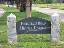
Hermitage Road Historic District (HRHD) is a Northside neighborhood in the independent city of Richmond, Virginia. The district is a Richmond Old and Historic District, as well as being listed on the Virginia Landmarks Register and the National Register of Historic Places.

The East End of Richmond, Virginia is the quadrant of the City of Richmond, Virginia, and more loosely the Richmond metropolitan area, east of the downtown.

Spring Garden is a neighborhood in central Philadelphia, Pennsylvania, bordering Center City on the north. Spring Garden is a neighborhood that combines diverse residential neighborhoods and significant cultural attractions.

Union Hill is a historic district of Richmond, Virginia. According to the Richmond Times Dispatch, the neighborhood "generally is bordered on the south by East Marshall Street and Jefferson Avenue, on the west by Mosby Street, on the north by O and Carrington streets, and angled on the east by North 25th Street." The neighborhood is on the Virginia Landmarks Register and the National Register of Historic Places, and is also one of sixteen designated "Old and Historic Districts" in Richmond.

The Museum District, alternately known as West of the Boulevard, is a neighborhood in the city of Richmond, Virginia. It is anchored by the contiguous six-block tract of museums along the west side of Boulevard, including the Virginia Museum of Fine Arts and the Virginia Museum of History & Culture, hence the name.

The Chestnut Hill–Plateau Historic District is a historic area in the Highland Park neighborhood of Richmond, Virginia. It is also known as 'Highland Park Southern Tip' on city neighborhood maps.

Girard Avenue is a major commercial and residential street in Philadelphia. For most of its length it runs east–west, but at Frankford Avenue it makes a 135-degree turn north. Parts of the road are signed as U.S. Route 13 and U.S. Route 30.


