
The Fan is a district of Richmond, Virginia, so named because of the "fan" shape of the array of streets that extend west from Belvidere Street, on the eastern edge of Monroe Park, westward to Arthur Ashe Boulevard. However, the streets rapidly resemble a grid after they go through what is now Virginia Commonwealth University. The Fan is one of the easterly points of the city's West End section, and is bordered to the north by Broad Street and to the south by VA 195, although the Fan District Association considers the southern border to be the properties abutting the south side of Main Street. The western side is sometimes called the Upper Fan and the eastern side the Lower Fan, though confusingly the Uptown district is located near VCU in the Lower Fan. Many cafes and locally owned restaurants are located here, as well as historic Monument Avenue, a boulevard formerly featuring statuary of the Civil War's Confederate president and generals. The only current statue is a more modern one of tennis icon Arthur Ashe. Development of the Fan district was strongly influenced by the City Beautiful movement of the late 19th century.
The Greater Richmond, Virginia area has many neighborhoods and districts.
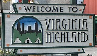
Virginia–Highland is a neighborhood of Atlanta, Georgia, founded in the early 20th century as a streetcar suburb. It is named after the intersection of Virginia Avenue and North Highland Avenue, the heart of its trendy retail district at the center of the neighborhood. The neighborhood is famous for its bungalows and other historic houses from the 1910s to the 1930s. It has become a destination for people across Atlanta with its eclectic mix of restaurants, bars, and shops as well as for the Summerfest festival, annual Tour of Homes and other events.

Wilshire Boulevard (['wɪɫ.ʃɚ]) is a prominent 15.83 mi (25.48 km) boulevard in the Los Angeles area of Southern California, extending from Ocean Avenue in the city of Santa Monica east to Grand Avenue in the Financial District of downtown Los Angeles. One of the principal east–west arterial roads of Los Angeles, it is also one of the major city streets through the city of Beverly Hills. Wilshire Boulevard runs roughly parallel to Santa Monica Boulevard from Santa Monica to the west boundary of Beverly Hills. From the east boundary, it runs a block south of Sixth Street to its terminus.

State Route 161 is a primary state highway in and near Richmond, Virginia, United States. It extends from an interchange with Interstate 95 (I-95) in the independent city of Richmond north to an intersection with U.S. Route 1 in the Lakeside area of central Henrico County.

The Southside of Richmond is an area of the Metropolitan Statistical Area surrounding Richmond, Virginia. It generally includes all portions of the City of Richmond that lie south of the James River, and includes all of the former city of Manchester. Depending on context, the term "Southside of Richmond" can include some northern areas of adjacent Chesterfield County, Virginia in the Richmond-Petersburg region. With minor exceptions near Bon Air, VA, the Chippenham Parkway forms the border between Chesterfield County and the City of Richmond portions of Southside, with some news agencies using the term "South Richmond" to refer to the locations in Southside located in the city proper.
The Northside is an area composed of northern Richmond, Virginia and some parts of Henrico County, Virginia.

U.S. Route 60 (US 60) in the Commonwealth of Virginia runs 303 miles (488 km) west to east through the central part of the state, generally close to and paralleling the Interstate 64 corridor, except for the crossing of the Blue Ridge Mountains, and in the South Hampton Roads area.

Downtown Oakland is the central business district of Oakland, California, United States. It is located roughly bounded by both the Oakland Estuary and Interstate 880 on the southwest, Interstate 980 on the northwest, Grand Avenue on the northeast, and Lake Merritt on the east.

Ponce de Leon Avenue, often simply called Ponce, provides a link between Atlanta, Decatur, Clarkston, and Stone Mountain, Georgia. It was named for Ponce de Leon Springs, in turn from explorer Juan Ponce de León, but is not pronounced as in Spanish. Several grand and historic buildings are located on the avenue.

Charles Morrison Robinson, most commonly known as Charles M. Robinson, was an American architect. He worked in Altoona and Pittsburgh, Pennsylvania from 1889 to 1906 and in Richmond, Virginia from 1906 until the time of his death in 1932. He is most remembered as a prolific designer of educational buildings in Virginia, including public schools in Richmond and throughout Virginia, and university buildings for James Madison University, College of William and Mary, Radford University, Virginia State University, University of Mary Washington, and the University of Richmond. He was also the public school architect of the Richmond Public Schools from 1910 to 1929. Many of his works have been listed on the National Register of Historic Places.
Linwood Boulevard is a boulevard and major east–west street in Kansas City, Missouri, United States. Linwood begins at Broadway Boulevard in the Valentine and Old Hyde Park neighborhoods and travels 3.8 miles east through Midtown to Van Brunt Boulevard near Interstate 70 in the Kansas City East Side. For much of its length, it creates a high-density corridor with 31st Street, another major street running parallel one block north. It continues west of Broadway Boulevard as 33rd Street past Metropolitan Community College-Penn Valley. Linwood Boulevard is one of the few named east–west streets in the Kansas City grid south of the Missouri River.

Highland Park Public School is a historic school building located in Richmond, Virginia. The structure was built in 1909 based on a design by noted Virginia architect Charles M. Robinson. The Mediterranean Revival building is a two-story brick and stucco structure topped by hipped roofs clad with terra cotta tiles. In its use of the Mediterranean Revival style, the building was a departure from the Georgian and Gothic styles commonly used in Virginia school buildings of the time. The building used as the community school for Highland Park, Virginia, until the community was annexed by the City of Richmond in 1914. It served thereafter as a neighborhood school in the Richmond public school system until it closed in the 1970s. The building is considered to be important as an example of the work of Charles M. Robinson, who served as Richmond School Board architect from 1909 to 1930. The building was listed on the National Register of Historic Places in 1991. The building was converted from 1990 to 1991 into a residential apartment complex for senior citizens and re-opened under the name Brookland Park Plaza.
The History of Virginia–Highland, the Intown Atlanta neighborhood, dates back to 1812, when William Zachary bought and built a farm on 202.5 acres (0.819 km2) of land there. At some point between 1888 and 1890 the Nine-Mile Circle streetcar arrived, making a loop of what are now Ponce de Leon Avenue, North Highland Avenue, Virginia Avenue, and Monroe Drive. Atlantans at first used the line to visit what was then countryside, including Ponce de Leon Springs, but the line also enabled later development in the area. Residential development began as early as 1893 on St. Charles and Greenwood Avenues, must most development took place from 1909 through 1926 — solidly upper-middle class neighborhoods, kept all-white by covenant.

The Chestnut Hill–Plateau Historic District is a historic area in the Highland Park neighborhood of Richmond, Virginia. It is also known as 'Highland Park Southern Tip' on city neighborhood maps.

The Brookland Park Historic District is a national historic district located at Richmond, Virginia. The district encompasses 1,157 contributing buildings located north of downtown Richmond and Barton Heights.

The Highland Park Plaza Historic District is a national historic district located at Highland Park, Richmond, Virginia. The district encompasses 1,005 contributing buildings located north of downtown Richmond and east of Barton Heights and Brookland Park. The primarily residential area developed starting in the late-19th century as one of the city's early "streetcar suburbs." It was added to the National Register of Historic Places in 2004.
Laburnum Avenue is a C-shaped highway in Henrico County and the city of Richmond in the U.S. state of Virginia. The highway extends 14.50 miles (23.34 km) from Virginia State Route 895 near Varina southeast of Richmond to Interstate 195 (I-195) on the North Side of the city of Richmond. Laburnum Avenue is a four-lane divided highway that connects the city's inner suburbs in eastern Henrico County. The highway also serves as a major east–west street in Richmond, on part of which the highway forms part of SR 197. Laburnum Avenue intersects all of the radial highways on the east side of Richmond, including SR 5, U.S. Route 60, I-64, SR 33, US 360, and US 1 and US 301.

Rockwood is a neighborhood in Spokane, Washington. It is located on the south side of the city to the southeast of Downtown Spokane and expanding southeasterly from close to the city center. Its proximity to downtown makes it one of Spokane's older neighborhoods, with mature trees lining most of its streets. Due to its location on the hill leading up from the Spokane River Valley, the street grid breaks down in many places around Rockwood. The most notable of these is along the winding Rockwood Boulevard, which was designed by the Olmsted Brothers and weaves its way from the northwesternmost corner of the neighborhood through the center and across to the eastern border, highlighting the basalt bluffs and other natural topography.
Adolph Dill, also known as Addolph Dill, was an American businessman, landowner, and baker during the Antebellum era in Richmond, Virginia. The Confederate States Army took over Dill's bakery to supply soldiers in 1864, re-naming it the "C. S. Bakery".

