
Richmond is the capital city of the Commonwealth of Virginia in the United States. Incorporated in 1742, Richmond has been an independent city since 1871. The city's population in the 2020 census was 226,610, up from 204,214 in 2010, making it Virginia's fourth-most populous city. The Richmond metropolitan area, with over 1.3 million residents, is the Commonwealth's third-most populous.
Church Hill, also known as the St. John's Church Historic District, is an Old and Historic District in Richmond, Virginia. This district encompasses the original land plat of the city of Richmond. Church Hill is the eastern terminus of Broad Street, a major east-west thoroughfare in the Richmond metropolitan area. The name Church Hill is often used to describe both the specific historic district and the larger general area in the East End encompassing other neighborhoods such as Union Hill, Chimborazo, Fairmount, Peter Paul, Woodville, etc.

Oregon Hill is a historic working-class neighborhood in Richmond, Virginia. Oregon Hill overlooks the James River and Belle Isle, and provides access to Hollywood Cemetery. Due to the neighborhood's proximity to the Monroe Park Campus of Virginia Commonwealth University, the neighborhood is sometimes referred to as a student quarter because of its high college student population.
The Greater Richmond, Virginia area has many neighborhoods and districts.

Richmond Hill is a commercial and residential neighborhood located in the southeastern section of the New York City borough of Queens. The area borders Kew Gardens and Forest Park to the north, Jamaica and South Jamaica to the east, South Ozone Park to the south, and Woodhaven and Ozone Park to the west. The neighborhood is split between Queens Community Board 9 and 10.

The Southside of Richmond is an area of the Metropolitan Statistical Area surrounding Richmond, Virginia. It generally includes all portions of the City of Richmond that lie south of the James River, and includes all of the former city of Manchester. Depending on context, the term "Southside of Richmond" can include some northern areas of adjacent Chesterfield County, Virginia in the Richmond-Petersburg region. With minor exceptions near Bon Air, VA, the Chippenham Parkway forms the border between Chesterfield County and the City of Richmond portions of Southside, with some news agencies using the term "South Richmond" to refer to the locations in Southside located in the city proper.

Highland Park is a neighborhood comprising several historic districts north of downtown Richmond, Virginia. Over time, various boundaries have served to split the neighborhood into sections traditionally labeled East Highland Park, North Highland Park, and South Highland Park. The southern Highland Park boundaries are roughly First Avenue to the west, Fifth Avenue to the east, the Shockoe Valley to the south, and E. Brookland Park Boulevard to the north. The Highland Park Southern Tip neighborhood is also known as the Chestnut Hill-Plateau Historic District. The Highland Park Plaza/Northern Highland Park boundaries are roughly defined by Pensacola ave and the railroad tracks to the north, Fifth avenue to the east, E. Brookland Park boulevard to the south, and Meadowbridge Road to the west. The zip code is 23222.
The Northside is an area composed of northern Richmond, Virginia and some parts of Henrico County, Virginia.
Woodland Heights, VA is a neighborhood in the city of Richmond, Virginia. It began as a trolleycar neighborhood in the early 1900s and was built up along the James River beside Forest Hill Park. Woodland Heights is listed on the National Register of Historic Places and the Virginia Landmarks Registry.

Jackson Ward, previously known as Central Wards, is a historically African-American district in Richmond, Virginia, with a long tradition of African-American businesses. It is located less than a mile from the Virginia State Capitol, sitting to the west of Court End and north of Broad Street. It was listed as a National Historic Landmark District in 1978. "Jackson Ward" was originally the name of the area's political district within the city, or ward, from 1871 to 1905, yet has remained in use long after losing its original meaning.
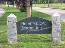
Hermitage Road Historic District (HRHD) is a Northside neighborhood in the independent city of Richmond, Virginia. The district is a Richmond Old and Historic District, as well as being listed on the Virginia Landmarks Register and the National Register of Historic Places.

Forest Hill Park, known for its "Stone house" called Boscobel, is a historic 105-acre (0.4 km2) urban park in Richmond, Virginia. Starting as a private property, the park has had several owners and uses before its present one, the City of Richmond.
Forest Hill or Forrest Hill may refer to:

Union Hill is a historic district of Richmond, Virginia. According to the Richmond Times Dispatch, the neighborhood "generally is bordered on the south by East Marshall Street and Jefferson Avenue, on the west by Mosby Street, on the north by O and Carrington streets, and angled on the east by North 25th Street." The neighborhood is on the Virginia Landmarks Register and the National Register of Historic Places, and is also one of sixteen designated "Old and Historic Districts" in Richmond.

The Chestnut Hill–Plateau Historic District is a historic area in the Highland Park neighborhood of Richmond, Virginia. It is also known as 'Highland Park Southern Tip' on city neighborhood maps.

Gambles Hill is a neighborhood near Downtown Richmond, Virginia. The neighborhood contains the Virginia War Monument, Historic Tredegar, Brown's Island and the WestRock Corporation.
Randolph is a historically black middle class neighborhood located within the West End of Richmond, Virginia. The neighborhood is named in honor of Virginia E. Randolph, a former African-American educator in Henrico County, Virginia during the 19th century. The neighborhood is bounded by the Downtown Expressway to the north, Harrison Street to the east, Colorado Avenue to the south, and South Meadow street to the west. Some famous landmarks and places of interest in the neighborhood include Petronius Park, the Randolph Community Center, and just adjacent to the neighborhood, the Hollywood Cemetery.

Libby Hill is a small neighborhood in Richmond, Virginia. Libby Hill is located on the southeastern spur of Church Hill, overlooking the James River and the Lucky Strike building. It is known for Libby Hill Park and "The View that Named Richmond". The Libby Hill neighborhood is entirely within the St. John's Church Historic District.
