Ravenden, Arkansas | |
---|---|
Coordinates: 36°14′2″N91°15′7″W / 36.23389°N 91.25194°W | |
Country | United States |
State | Arkansas |
County | Lawrence |
Area | |
• Total | 2.12 sq mi (5.49 km2) |
• Land | 2.11 sq mi (5.47 km2) |
• Water | 0.01 sq mi (0.03 km2) |
Elevation | 338 ft (103 m) |
Population (2020) | |
• Total | 426 |
• Density | 201.80/sq mi (77.93/km2) |
Time zone | UTC−06:00 (Central (CST)) |
• Summer (DST) | UTC−05:00 (CDT) |
ZIP Code | 72459 |
Area code | 870 |
FIPS code | 05-58250 |
GNIS feature ID | 0058465 [2] |
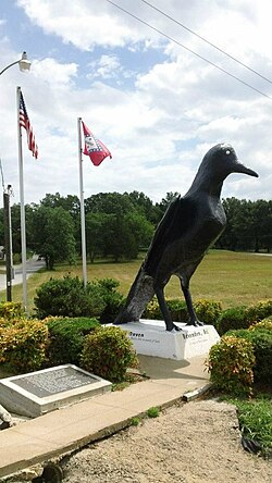
Ravenden is a town in Lawrence County, Arkansas, United States. The population was 470 at the 2010 census. [3] The town is in the valley of the Spring River along U.S. Highway 63 and the Burlington-Northern Railroad.
The community building, still in use, was dedicated in 1960. Ray Ellis was mayor at that time. The Frisco Railroad was bought out by, and merged with, the Burlington-Northern Railroad in 1980.
Ravenden is located in the northwest corner of Lawrence County at 36°14′2″N91°15′7″W / 36.23389°N 91.25194°W (36.233972, -91.251911). [4] U.S. Highways 62, 63, and 412 run concurrently through the north side of the town, leading northwest 16 miles (26 km) to Hardy and southeast 5 miles (8 km) to Imboden. Arkansas Highway 90 leads north from Ravenden 6 miles (10 km) to Ravenden Springs.
According to the United States Census Bureau, the town of Ravenden has a total area of 2.1 square miles (5.5 km2), of which 0.01 square miles (0.03 km2), or 0.58%, are water. [3] The Spring River, a southeast-flowing tributary of the Black River, flows through the southern part of the town.
Census | Pop. | Note | %± |
---|---|---|---|
1940 | 240 | — | |
1950 | 245 | 2.1% | |
1960 | 231 | −5.7% | |
1970 | 219 | −5.2% | |
1980 | 338 | 54.3% | |
1990 | 330 | −2.4% | |
2000 | 511 | 54.8% | |
2010 | 470 | −8.0% | |
2020 | 426 | −9.4% | |
U.S. Decennial Census [5] |
As of the census [6] of 2000, there were 511 people, 209 households, and 145 families residing in the town. The population density was 246.7 inhabitants per square mile (95.3/km2). There were 254 housing units at an average density of 122.6 per square mile (47.3/km2). The racial makeup of the town was 97.26% White, 1.76% Native American, 0.59% from other races, and 0.39% from two or more races. 1.37% of the population were Hispanic or Latino of any race.
There were 209 households, out of which 34.9% had children under the age of 18 living with them, 53.6% were married couples living together, 12.9% had a female householder with no husband present, and 30.6% were non-families. 26.8% of all households were made up of individuals, and 9.6% had someone living alone who was 65 years of age or older. The average household size was 2.44 and the average family size was 2.97.
In the town, the population was spread out, with 27.6% under the age of 18, 8.8% from 18 to 24, 24.9% from 25 to 44, 23.1% from 45 to 64, and 15.7% who were 65 years of age or older. The median age was 37 years. For every 100 females, there were 97.3 males. For every 100 females age 18 and over, there were 93.7 males.
The median income for a household in the town was $25,625, and the median income for a family was $29,896. Males had a median income of $23,281 versus $14,444 for females. The per capita income for the town was $10,723. About 19.5% of families and 28.4% of the population were below the poverty line, including 48.6% of those under age 18 and 15.1% of those age 65 or over.
Residents are zoned to the Sloan-Hendrix School District which operates Sloan-Hendrix High School. [7]
Sharp County is a county located in the U.S. state of Arkansas. As of the 2020 census, the population was 17,271. The county seat is Ash Flat. The county was formed on July 18, 1868, and named for Ephraim Sharp, a state legislator from the area.
Lawrence County is a county located in the U.S. state of Arkansas. As of the 2020 census, the population was 16,216. The county seat is Walnut Ridge. Lawrence County is Arkansas's second county, formed on January 15, 1815, and named for Captain James Lawrence who fought in the War of 1812. It is an alcohol prohibition or dry county.
Jackson County is located in the Arkansas Delta in the U.S. state of Arkansas. The county is named for Andrew Jackson, a national hero during the War of 1812. By the county's formation in 1829, Jackson had become the seventh President of the United States. Jackson County is home to seven incorporated towns and four incorporated cities, including Newport, the largest city and county seat. The county is also the site of numerous unincorporated communities and ghost towns. Occupying 633.94 square miles (164,190 ha), Jackson County is the 41st largest county of the 75 in Arkansas. As of the 2020 Census, the county's population was 16,755. Based on population, the county is the 44th-largest county in Arkansas. Although terrain rises in the west, most of Jackson County is within the Arkansas Delta, characterized by largely flat terrain with fertile soils. Historically covered in forest, bayous and swamps, the area was cleared for agriculture by early settlers. It is drained by the White River.
Independence County is a county located in the U.S. state of Arkansas. As of the 2020 census, the population was 37,938. The county seat is Batesville. Independence County is Arkansas's ninth county, formed on October 20, 1820, from a portion of Lawrence County and named in commemoration of the Declaration of Independence. It is an alcohol prohibition or dry county.
Fulton County is a county located in the U.S. state of Arkansas. As of the 2020 census, the population was 12,075. The county seat is Salem. Fulton County was formed on December 21, 1842, and named for William Fulton, the last governor of the Arkansas Territory. It is an alcohol prohibition or dry county.
Altus is a city in Franklin County, Arkansas, United States. Located within the Arkansas River Valley at the edge of the Ozark Mountains, the city is within the Fort Smith metropolitan area. The epicenter of the Altus American Viticultural Area (AVA) within Arkansas Wine Country, the city is home to four wineries. Although founded as a coal mining community, the wine industry has driven the Altus economy since the first vineyards were planted in 1872. The population was 758 at the 2010 census, down from 817 at the 2000 census. In 2020, the population was 669 and was estimated as unchanged in 2021 and 2022.
Black Rock is a city in Lawrence County, Arkansas, United States, along the Black River. The population was 662 at the 2010 census.
Imboden is a city in Lawrence County, Arkansas, United States. The population was 677 at the 2010 census. It is named after a family of settlers.
Lynn is a town in Lawrence County, Arkansas, United States. The population was 288 at the 2010 census.
Minturn is a town in Lawrence County, Arkansas, United States. The population was 109 at the 2010 census.
Portia is a town in Lawrence County, Arkansas, United States. The population was 437 at the 2010 census.
Powhatan is a town in Lawrence County, Arkansas, United States, along the Black River. The population was 72 at the 2010 census, up from 50 at the 2000 census.
Smithville is a town in Lawrence County, Arkansas, United States. The population was 78 at the 2010 census.
Walnut Ridge is a city in and the county seat of Lawrence County, Arkansas, United States. The population was 5,098 at the United States Census's 2019 estimate. Walnut Ridge lies immediately north of Hoxie. The two towns form a contiguous urban area with approximately 8,000 residents. Williams Baptist University is in College City, a formerly separate community that merged into Walnut Ridge in 2017.
Roe is a town in Monroe County, Arkansas, United States. Located at the junction of U.S. Route 79 and Arkansas Highway 33, the population was 68 at the 2020 census, down from 114 in 2010.
Pocahontas is a city in and the county seat of Randolph County, Arkansas, United States, along the Black River. According to the 2010 Census Bureau, the population of the city was 6,608.
Ravenden Springs is a town in Randolph County, Arkansas, United States. The population was 119 at the 2020 census.
Hardy is the 2nd oldest city in Sharp and Fulton counties in the U.S. state of Arkansas. The population was 765 in 2020.
Bald Knob is a city in White County, Arkansas, United States. The population was 2,897 at the 2010 census. Located at the intersection of two of the state's natural regions, Bald Knob is often promoted as "where the Ozarks meet the Delta". Bald Knob is known for its yearly Home Fest held during Mother's Day weekend. It was once known as the leading strawberry producer in the world in the 1950s. Bald Knob was established in 1881.
Silver Creek is a town in Lawrence County, Mississippi, United States. The population was 210 at the 2010 census. Silver Creek is accessed from U.S. Route 84 and Mississippi Highway 43. The film Jesse James' Women (1954) was filmed in Silver Creek.