Rock Drawings in Valcamonica

Last updated
Rock Drawings in Valcamonica
UNESCO World Heritage Site
Scena di duello R6 - Foppe - Nadro (Foto Luca Giarelli).jpg
Petroglyphs in Nadro
Location Val Camonica, Province of Brescia, Lombardy, Italy
Criteria Cultural: (iii), (vi)
Reference 94
Inscription1979 (3rd Session)
Area432.3 ha (1,068 acres)
Buffer zone1,018.23 ha (2,516.1 acres)
Coordinates 45°57′25.4″N10°17′50.4″E / 45.957056°N 10.297333°E / 45.957056; 10.297333
Italy Lombardy location map.svg
Red pog.svg
Location of Rock Drawings in Valcamonica in Lombardy
Italy relief location map.jpg
Red pog.svg
Rock Drawings in Valcamonica (Italy)

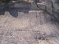
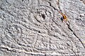
The rock drawings in Valcamonica (Camonica Valley) are located in the Province of Brescia, Italy, and constitute the largest collections of prehistoric petroglyphs in the world. [1] The collection was recognized by UNESCO in 1979 and was Italy's first recognized World Heritage Site. UNESCO has formally recognized more than 140,000 figures and symbols, [1] but new discoveries have increased the number of catalogued incisions to between 200,000 [2] and 300,000. [3] The petroglyphs are spread on all surfaces of the valley, but concentrated in the areas of Darfo Boario Terme, Capo di Ponte, Nadro, Cimbergo and Paspardo.

Contents

Characteristics

The vast majority of the petroglyphs are made on subglacially streamlined bedrock and glacial erratic surfaces revealed as the last glacier to form the valley retreated approximately 15,000 years ago.

Many of the incisions were made over a time period of eight thousand years preceding the Iron Age (1st millennium BC), [2] while petroglyphs of the last period are attributed to the people of Camuni, mentioned by Latin sources. The petroglyph tradition does not end abruptly. Engravings have been identified (although in very small number; not comparable with the great prehistoric activity) from the Roman period, medieval period and are possibly even contemporary, up to the 19th century. [1] [3] Most of the cuts have been made using the "martellina" technique and lesser numbers obtained through graffiti. [2]

The Camunian rose Rosa camuna R24 - Foppe - Nadro (Foto Luca Giarelli).jpg
The Camunian rose
"The astronauts", c. 1.000 BC Antropomorfi detti astronauti (a) - R 1 - Area di Zurla - Nadro (ph Luca Giarelli).jpg
"The astronauts", c. 1.000 BC

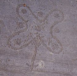
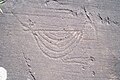
The figures are sometimes simply superimposed without apparent order. Others instead appear to have a logical relationship between them; for example, a picture of a religious rite or a hunting scene or fight. This approach explains the scheme of images, each of which is an ideogram that is not the real object, but its "idea". [2] Their function pertains to celebratory rituals: commemorative, initiatory and propitiatory; first in the field of religion, then later even secular, which were held on special occasions, either single or recurrent. [3] Among the most-famous symbols found in Valcamonica is the so-called "Rosa camuna" (Camunian rose), which was adopted as the official symbol of the region of Lombardy.

The historiated cycle: themes and periodization

In the 1960s, the archaeologist Emmanuel Anati, among the first to systematically study the area, drew up a chronology of rock carvings. It compared the style and types of the symbols to identify possible correlations with the traditional historical periodization, from Prehistory to the Middle Ages. [4]

According to Anati's research results, Val Camonica is divided into Proto-Camunian, Camunian I, II, III, IV and Post-Camunian (Roman, Medieval ages and recent) periods. [5]

Proto-Camunian periodFinal Paleolithic,Epipaleolithic and Proto-Neolithic
The Camunian INeolithic
The Camunian IINeolithic
The Camunian IIIChalcolithic, Early and Middle Bronze Age
The Camunian IVThe late and final Bronze Age, Iron Age

Epipaleolithic

The earliest rock carvings date back to epipaleolithic (or Mesolithic, Proto-Camunian, [5] 8th-6th millennium BC), several millennia after the retreat of the glacier that covered the Val Camonica (Würm glaciation). Those carvings were the work of passing nomadic hunters, following the migrations of their prey. The figures represented in fact depict large animals such as deer and elk, which are the typical prey of that period. The drawings also describe animals wounded with spears. This kind of rock art can be typical for hunters-gatherers and associated with blades and microlites industry. [5] Similar representations are present in the stone carvings of Luine Municipal Park ( comune of Darfo Boario Terme). [6]

Neolithic

During the Neolithic period (the 5th to 1st centuries of the 4th millennium BC approximately-5500-3300 BC [5] ), agricultural practices spread in Val Camonica, correlated with the formation of the first sedentary settlements. In the field of rock art, human figures and sets of geometric elements, such as rectangles, circles, and dots, constitute the main elements of the compositions and complete the symbolic meaning of the anthropomorphical petroglyphs. [7] Similar carvings are present in the Regional Reserve of Rock Engravings of Ceto, Cimbergo, and Paspardo. [8] The pertaining to the Neolithic of the schematic anthropomorphic figures, so called "oranti" ("praying figures"), is questioned, as some scholars refer them to the Bronze Age. [9] According to this interpretation, the only set of figures pertaining to the Neolithic, or to a Neolithic-first Copper Age phase (4th mill. BC), is constituted by the geometric patterns, which are interpreted as topographic representation of a cultivated and ploughed land. [10]

During this period, domesticated animals are encountered such as dogs, goats and bulls. [5]

Until the end of the Camunian II period, objects of worshipping became wider. Particularly, the dog, the first-domesticated animal started to be worshipped. [5]

Copper Age

During the Copper Age (or Chalcolithic period, the 3rd millennium BC approximately-3300-2500 BC [5] ), new symbols appeared, documenting the emergence of the wheel, the wagon and the first forms of metallurgy. Alpine rock art began to develop in this period. [11] Rocks were stained with celestial symbols, animals, weapons, depictions of plowing, chains of human-beings and other signs. Although the anthropomorphic figures were primitive at first, later these images were even more intense and more complicated by adding weapons, astral disks and rectangular that symbolize the world in addition to simple figures. [5] [12] These monuments, preserved mainly in the Archaeological Park of National Massi Cemmo and in that of Asinino-Anvòia (Ossimo), indicate a ritual function linked to the veneration of ancestors. [13]

Deer-hunting scene Scena di caccia al cervo - Seradina R 12 - Capo di Ponte (Foto Luca Giarelli).jpg
Deer-hunting scene

Bronze Age

During the Bronze Age (2nd millennium BC, approximately), engravings on rock outcrops took on the issue of weapons, reflecting the greater emphasis given them by the warriors in the Camunian society of the time. Continuing emphasis was given to geometric shapes (circles and variants), in continuity with engravings from earlier eras. [14]

Iron Age

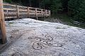
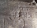
The engravings of the Iron Age (1st millennium BC) are attributed to the people of Camunni and constitute about 70-80% of all census figures. These works manifest their ideals of heroic masculinity and superiority. Dominant themes include representations of duels and human figures, even large ones, flaunting their weapons, their muscles and their genitals. There are also figures of cabins, labyrinths, footprints, hunting scenes and other symbols. [15] Topographic patterns are also present, mainly in the central part of the Iron Age (6th-4th century BC), like in the famous Bedolina Map, firstly studied by Miguel Beltrán Llorís [16] and more recently by Cristina Turconi [17] for the Milan University, one of the best known engraved surfaces of the Camonica Valley.

Roman Age

During the Roman domination of Val Camonica (~100 BC - ~500 AD) petroglyph activity suffered a sharp contraction, entering a phase of latency. [18] [19]

Medieval Age

The Middle Ages in Val Camonica marked a resumption of the rock engravery, starting from the first phase of the Medieval Ages. Many of the inscriptions during this period are Christian symbols, such as crosses and keys, that were joined and overlapped with those considered pagan symbols, in the background, in an attempt to sacralize these places. [19]

Discovery and evaluation

The first documented report of the engraved stones dates back to 1909, when Walther Laeng pointed out to the National Committee for the Protection of Monuments two boulders decorated around Cemmo (Capo di Ponte). Only in the 1920s, however, did the rocks pique the interest of scholars, including Giuseppe Bonafini, geologist Senofonte Squinabol, and, since 1929, Torinese anthropologist Giovanni Marro and Florentine archaeologist Paolo Graziosi. Soon numerous engravings were also discovered on the surrounding rocks, and research was conducted not only by Marro, but also by Raffaele Battaglia for the Superintendent to the Antiquities of Padua. [20]

In the 1930s, the reputation of the cuts was more commonly known in Italy and abroad, so that between 1935 and 1937 an extensive campaign of studies was conducted by Germans Franz Altheim and Erika Trautmann. Altheim started reading Nazi ideologies into the engravings, which were soon imitated in a fascist work by Marro, identifying them as evidence of a supposed ancestral Aryan race. [20]

The mapping and cataloging resumed after the Second World War, led by Laeng and conducted by scholars of the infant Museum of Natural Sciences of Brescia, consisting of both national and international experts. In 1955, with the institution of the Parco nazionale delle incisioni rupestri di Naquane by the Archaeological Superintendent of Lombardy, work began to preserve the rocks and their inscriptions. [20] The explorations of Emmanuel Anati began in 1956 and discovered new petroglyphs. The systematic nature of these studies enabled him to publish, in 1960, the first volume of general summary about "La civilization du Val Camonica". In 1964, Anati founded the Centro Camuno di Studi Preistorici (Camunian Center of Prehistoric Studies). The first "Valcamonica Symposium", was held in 1968; first in a long series of conferences, convening in Valcamonica many scholars of art and prehistoric life. [21]

After its inclusion by UNESCO as World Heritage Site number 94, continuing research has further broadened the heritage rocks recorded. [21]

Parks of rock art

NameMunicipalityCoordinatesPetroglyphs
1. Parco nazionale delle incisioni rupestri di Naquane Capo di Ponte 46°01′32″N10°20′57″E / 46.02556°N 10.34917°E / 46.02556; 10.34917
2. Parco archeologico nazionale dei Massi di Cemmo Capo di Ponte 46°01′52″N10°20′20″E / 46.03111°N 10.33889°E / 46.03111; 10.33889
3. Parco archeologico comunale di Seradina-Bedolina Capo di Ponte 46°02′00″N10°20′29″E / 46.03333°N 10.34139°E / 46.03333; 10.34139
4. Parco archeologico di Asinino-Anvòia Ossimo 45°57′19″N10°14′47″E / 45.95528°N 10.24639°E / 45.95528; 10.24639
5. Parco comunale delle incisioni rupestri di Luine Darfo Boario Terme 45°53′20″N10°10′46″E / 45.88889°N 10.17944°E / 45.88889; 10.17944
6. Parco comunale archeologico e minerario di Sellero Sellero 46°03′26″N10°20′29″E / 46.05722°N 10.34139°E / 46.05722; 10.34139
7. Parco archeologico comunale di Sonico Sonico 46°10′7″N10°21′20″E / 46.16861°N 10.35556°E / 46.16861; 10.35556
8. Riserva naturale Incisioni rupestri di Ceto, Cimbergo e Paspardo Ceto (Nadro)
Cimbergo
Paspardo
46°01′6″N10°21′10″E / 46.01833°N 10.35278°E / 46.01833; 10.35278

See also

Notes

  1. 1 2 3 "Rock Drawings in Valcamonica - UNESCO World Heritage Centre" . Retrieved 29 June 2010.
  2. 1 2 3 4 Piero Adorno, Mesolitico e Neolitico, p. 16.[ full citation needed ]
  3. 1 2 3 "Introduzione all'arte rupestre della Valcamonica" [Introduction to the rock art of Valcamonica] (in Italian). Archeocamuni.it. Retrieved 11 May 2009.
  4. "Il ciclo istoriativo camuno" [Restoration cycle] (in Italian). Archeocamuni.it. Retrieved 10 September 2009.
  5. 1 2 3 4 5 6 7 8 "The Way of Life Recorded in the Rock Art of Valcamonica" (PDF).
  6. "L'Epipaleolitico camuno on Archeocamuni.it" (in Italian). Retrieved 11 September 2009.
  7. "Il Neolitico camuno on Archeocamuni.it" (in Italian). Retrieved 10 September 2009.
  8. "Riserva Regionale delle Incisioni Rupestri di Ceto, Cimbergo e Paspardo" (in Italian). World Wide Meta Museum. Archived from the original on 25 July 2011. Retrieved 10 September 2009.
  9. Arcà Andrea, 2001. Chronology and interpretation of the “Praying figures” in Valcamonica rock-art. In: Archeologia e arte rupestre: l’Europa – le Alpi – la Valcamonica, secondo convegno internazionale di archeologia rupestre. Atti del Convegno di studi, 2-5 ottobre 1997, Darfo Boario terme, Milano: 185-198, online as TRACCE open access paper
  10. Arcà, Andrea (18 September 1997). "Settlements in topographic engravings". TRACCE Online Rock Art Bulletin (9).
  11. Defresne, Claudia (2016). "Rock Art Studies: News from the Alps (2010-2014)". Rock Art Studies: News of the world. Vol. 5. Archaeopress Archaeology. ISBN   978 1 78491 354-0.
  12. Gavaldo, Silvana; Sansoni, Umberto (2012). "Rock Art in Valcamonica: the last four years of research and discoveries" (PDF). Adoranten.
  13. "L'età del Rame camuna on Archeocamuni.it" (in Italian). Retrieved 10 September 2009.
  14. "L'età del Bronzo camuna" [Bronze Age Camuna] (in Italian). Archeocamuni.it. Retrieved 10 September 2009.
  15. "L'età del Ferro camuna" [Iron Age Camuna] (in Italian). Archeocamuni.it. Retrieved 10 September 2009.
  16. Beltrán Llorís M., 1972. Los grabados rupestres de Bedolina (Valcamonica), BCSP, vol. VIII, Capo di Ponte (BS): 121-158
  17. Turconi, C. (1997). "The map of Bedolina, Valcamonica Rock Art". TRACCE Online Rock Art Bulletin (9).
  18. "L'età romana in Valcamonica" [Roman Age in Valcamonica] (in Italian). Archeocamuni.it. Retrieved 10 September 2009.
  19. 1 2 "L'età medioevale sulle rocce camune" [Middle Ages of Camuna] (in Italian). Archeocamuni.it. Retrieved 10 September 2009.
  20. 1 2 3 "Alberto Marretta, Una breve storia delle ricerche in Valcamonica (parte 1) on Archeocamuni.it" [A brief history of the research in Valcamonica] (in Italian). Retrieved 13 May 2009.
  21. 1 2 "Alberto Marretta, Una breve storia delle ricerche in Valcamonica (parte 2) on Archeocamuni.it" (in Italian). Retrieved 13 May 2009.

Bibliography

Commons-logo.svg Media related to Petroglyphs in Val Camonica at Wikimedia Commons

Related Research Articles

<span class="mw-page-title-main">Petroglyph</span> Images carved on a rock surface as a form of rock art

A petroglyph is an image created by removing part of a rock surface by incising, picking, carving, or abrading, as a form of rock art. Outside North America, scholars often use terms such as "carving", "engraving", or other descriptions of the technique to refer to such images. Petroglyphs, estimated to be 20,000 years old are classified as protected monuments and have been added to the tentative list of UNESCO's World Heritage Sites. Petroglyphs are found worldwide, and are often associated with prehistoric peoples. The word comes from the Greek prefix petro-, from πέτρα petra meaning "stone", and γλύφω glýphō meaning "carve", and was originally coined in French as pétroglyphe.

The Camunic language is an extinct language that was spoken in the 1st millennium BC in Val Camonica, a valley in the Central Alps. The language is sparsely attested to an extent that makes any classification attempt uncertain - even the discussion of whether it should be considered a pre–Indo-European or an Indo-European language has remained indecisive. Among several suggestions, it has been hypothesized that Camunic is related to the Raetic language from the Tyrsenian language family, or to the Celtic languages.

<span class="mw-page-title-main">Cup and ring mark</span> Form of prehistoric art

Cup and ring marks or cup marks are a form of prehistoric art found in the Atlantic seaboard of Europe (Ireland, Wales, Northern England, Scotland, France, Portugal, and Spain – and in Mediterranean Europe – Italy, Azerbaijan and Greece, as well as in Scandinavia and in Switzerland.

<span class="mw-page-title-main">Province of Brescia</span> Province of Italy

The province of Brescia is a province in the Lombardy region of Italy. It has a population of some 1,265,964 and its capital is the city of Brescia.

<span class="mw-page-title-main">Breno, Lombardy</span> Comune in Lombardy, Italy

Breno is an Italian comune of 4,986 inhabitants in Val Camonica, province of Brescia, in Lombardy.

<span class="mw-page-title-main">Capo di Ponte</span> Comune in Lombardy, Italy

Capo di Ponte is an Italian comune in Val Camonica, province of Brescia, in Lombardy.

<span class="mw-page-title-main">Cimbergo</span> Comune in Lombardy, Italy

Cimbergo is an Italian comune of 572 inhabitants in Val Camonica, province of Brescia, in Lombardy.

<span class="mw-page-title-main">Cividate Camuno</span> Comune in Lombardy, Italy

Cividate Camuno is an Italian comune of 2,774 inhabitants (2011), in Val Camonica, province of Brescia, in Lombardy.

<span class="mw-page-title-main">Sellero</span> Comune in Lombardy, Italy

Sellero is a comune of 1,503 people in the province of Brescia in the middle Val Camonica.

<span class="mw-page-title-main">Val Camonica</span>

Val Camonica or Valcamonica, also Valle Camonica and anglicized as Camonica Valley, is one of the largest valleys of the central Alps, in eastern Lombardy, Italy. It extends about 90 kilometres (56 mi) from the Tonale Pass to Corna Trentapassi, in the commune of Pisogne near Lake Iseo. It has an area of about 1,335 km2 (515 sq mi) and 118,323 inhabitants. The River Oglio runs through its full length, rising at Ponte di Legno and flowing into Lake Iseo between Pisogne and Costa Volpino.

<span class="mw-page-title-main">Camunni</span> Ancient population during the Iron Age

The Camuni or Camunni were an ancient population located in Val Camonica during the Iron Age ; the Latin name Camunni was attributed to them by the authors of the 1st century. They are also called ancient Camuni, to distinguish them from the current inhabitants of the valley. The Camunni were among the greatest producers of rock art in Europe; their name is linked to the famous rock engravings of Valcamonica.

Prehistoric Rock Art Sites in the Côa Valley and Siega Verde are a United Nations Educational, Scientific and Cultural Organization (UNESCO) transboundary World Heritage Site, located in the Côa Valley of Portugal and Siega Verde, Spain.

<span class="mw-page-title-main">Nadro</span> Hamlet

Nadro is an Italian hamlet (frazione) of the comune of Ceto (BS), Lombardy. It has 655 inhabitants.

<span class="mw-page-title-main">Camunian rose</span> Prehistoric symbol from the petroglyphs of Valcamonica

The Camunian rose is the name given to a particular symbol represented among the rock carvings of Camonica Valley. It consists of a meandering closed line that winds around nine cup marks. It can be symmetrical, asymmetrical or form a swastika.

<span class="mw-page-title-main">Vallée des merveilles</span>

The Vallée des Merveilles, also known in Italian as the Valle delle Meraviglie, is a part of the Mercantour National Park in southern France. It holds the largest quantity of open-air Bronze Age petroglyphs in Europe, after Val Camonica in Italy, and is given special note for the area's inclusion for the European Diploma of Protected Areas.

<span class="mw-page-title-main">Emmanuel Anati</span> Italian archaeologist

Emmanuel Anati is an Italian archaeologist.

<span class="mw-page-title-main">Rock art Natural reserve of Ceto, Cimbergo and Paspardo</span>

The Rock art Natural Reserve of Ceto, Cimbergo and Paspardo is a nature reserve located in Valle Camonica, Province of Brescia, Lombardy, Italy. It was established in 1988.

<span class="mw-page-title-main">Bedolina Map</span> Iron age map engraved into rock

The Bedolina Map is a famous engraved prehistoric rock which is part of the Camonica Valley petroglyph complex. It is known as one of the most ancient topographic maps, interpreted as a depiction of cultivated plots, mountain paths and villages. The locality of Bedolina pertains to the Capo di Ponte municipality (BS-I), near the hamlet of Pescarzo. The area is included in the Seradina-Bedolina Archaeologic park, lying on a prominent terrace on the right slope of the Camonica valley, at an altitude of 530 m above the sea level. The rock, a flat surface of Permian sandstone polished by the Pleistocene glacier, is 9 m long and 4 m wide.

Erika Trautmann-Nehring (1897–1968) was a German archaeologist and illustrator, most noted for her work with Franz Altheim on the petroglyphs of Val Camonica, Italy.

<span class="mw-page-title-main">Gobustan Rock Art</span> UNESCO World Heritage Site

Gobustan Rock Art represents flora and fauna, hunting, lifestyles, and culture of pre-historic and medieval periods of time. The carvings on the rocks illustrates men, ritual dances, men with lances in their hands, animals, bull fights, camel caravans, and pictures of the sun and stars. The date of these carvings goes back to 5,000 – 20,000 years before present.