Rogue River Ranch

Last updated
Rogue River Ranch
Rogue River Ranch National Historic Site.jpg
Rogue River Ranch National Historic Site
USA Oregon location map.svg
Red pog.svg
Usa edcp location map.svg
Red pog.svg
Location Curry County, Oregon, USA
Nearest city Agness, Oregon
Coordinates 42°43′07″N123°52′54″W / 42.71864°N 123.88154°W / 42.71864; -123.88154 Coordinates: 42°43′07″N123°52′54″W / 42.71864°N 123.88154°W / 42.71864; -123.88154
Built1903–1930s
ArchitectGeorge Billings
Architectural styleCommon wood frame
NRHP reference No. 75001581
Added to NRHP1975

The Rogue River Ranch is a pioneer farm complex in Curry County in southwest Oregon, United States. The ranch is located on the north shore of the Rogue River just outside the Rogue River-Siskiyou National Forest. The original ranch buildings were constructed by George Billings. Later, the ranch was sold to Stanley Anderson, who increased the size of the property and built additional farm buildings. The Bureau of Land Management bought the ranch in 1970. Today, the main ranch house is a museum. The Bureau of Land Management also maintains a campground on the property. The Rogue River Ranch is listed on the National Register of Historic Places.

Contents

History

Archeological evidence shows that Native Americans occupied the area around the Rogue River Ranch for over 9,000 years. Ancient Takelma speaking people were the first to make their home in Rogue River valley. Later, Athabascan speaking people migrated into the area. While their languages were different, both groups shared a common way of life based on fishing, hunting, and gathering. For thousands of years, the site that is now the Rogue River Ranch was a seasonal camp. However, it appears likely a permanent village was eventually established at the site. The Native American way of life along the Rogue River came to an end in 1856 when the native people were removed to reservations in northern Oregon. [1] [2]

In 1887, Tom Billings filed an official homestead claim on the north shore of the Rogue River at the mouth of Mule Creek. The following year, Tom transferred the claim to his older brother, George. In 1894, Tom and his wife, Anna, had their first child, a daughter named Marial. The settlement at Mule Creek was named Marial, after her. [2] [3]

Front view of the Rogue River Ranch main house Rogue River Ranch Main House (front view).jpg
Front view of the Rogue River Ranch main house

In 1903, George Billings constructed a large two-story house and established the Billings Trading Company at Marial. Billings also ran a boarding house for travelers and local miners. Over time, the trading post became the center of commercial and social life for residents of Marial, who eventually number around 100 people. In 1907, Billings sold his property on the west side of Mule Creek, an area called Douglas Bar, to the Red River Mining and Milling Company. The next year, Billings built a barn on his remaining property. The building eventually became known as the tabernacle. Billings hosted dances and church services in the tabernacle. The Red River Mining Company closed in 1912, and Billings re-acquired the property on the west side of the creek. In 1931, Billings sold his 70-acre (280,000 m2) ranch to Stanley Anderson for $5,000. [2]

Site map of the historic Rogue River Ranch Rogue River Ranch Site Map.png
Site map of the historic Rogue River Ranch

The Anderson family later purchased 130 acres (0.53 km2) across the river from the ranch. In the years following the purchase of the ranch, the Anderson family expanded the main house and built a caretaker's house, bunkhouse, blacksmith shop, tackhouse, woodshed, storage shed, and chicken coop. The Andersons also tore down most of the old mining buildings at Douglas Bar. The Marial post office, which had been open since in 1903, was closed in 1954. In 1956, Anderson painted the main house a distinctive red, a color it still retains. In 1970, the Anderson family sold their 200-acre (0.81 km2) ranch to the United States Government under the National Wild and Scenic Rivers program, and the Bureau of Land Management was given responsibility for managing the property. [2] [3]

The Bureau of Land Management established the Rogue River Ranch National Historic Site and converted the main house into a museum. The museum has displays on Native American history, the local mining era, the Billings homestead period, and the development of the Anderson family farm. The Rogue River Ranch museum is open to visits from May to October. [2]

The Rogue River Ranch offers visitors the opportunity to experience the rich heritage of the Rogue River canyon area. Because the ranch played an important role in the commercial and social development of the local area, the Rogue River Ranch was listed on the National Register of Historic Places on 29 December 1975. This historic ranch covers 700 acres (2.8 km2). There are four historic buildings on the property and six non-contributing structures. [1] [4] [5]

Structures

There are four ranch buildings open to the public. They are the tackhouse, the blacksmith shop, the tabernacle, and the main house museum. There is also a caretaker's house, a large barn, and several minor farm buildings that are not open to the public. [2]

The main house was built in 1903. It sits on a gentle slope facing Mule Creek. The house is a two-story, wood-frame structure. The lumber for the house was all cut by hand from Ponderosa pine logs cut on the site. The siding was smoothed with hand planes down to one quarter inch in thickness. The window glass was shipped overland from Portland, but the window frames were handmade at the ranch. The main house does not have a fireplace. It is heated by a wood-burning stove in the living room. [2]

The other ranch buildings are also wood-frame structures with wood-lap siding. The Bureau of Land Management renovated the Tackhouse in 2008. The project replaced badly rotted framing members that had made the entire structure unsound. [6]

Location

Rogue River Ranch National Historic Site is located in the Rogue River canyon in southern Oregon. The ranch is at the mouth of Mule Creek on the north shore of the Rogue River at an elevation of approximately 420 feet (130 m) above sea level. It is an isolated property, surrounded by the Rogue River-Siskiyou National Forest. The ranch is a major stop over point along the wild section of the Rogue River, which has been officially designated a National Wild and Scenic River. [1] [7]

The Rogue River Ranch is 45 miles (72 km) northwest of Galice, 42 miles (68 km) southwest of Glendale, 24 miles (39 km) southeast of Powers, and 23 miles (37 km) northeast of the small unincorporated community of Agness. It takes at least two hours to reach the ranch from any of these starting points. There are no gas stations along the route, so visitors driving to the ranch should depart with a full tank of gas. The nearest city is Grants Pass, which is 75 miles (121 km) from the ranch by way of Galice or Glendale. [1] [2] [7]

The ranch can also be reached by boating down the Rogue River or by hiking the Rogue River canyon trail. The ranch is 22 river miles from Grave Creek Bridge (which is 8 miles (13 km) north of Galice), or 23-mile (37 km) along the canyon trail. Most people make the float trip in two days. The canyon hike from Grave Creek usually takes three days. [1] [2]

Because the Rogue River Ranch is a popular stopping point for boater floating down the Rogue River and hikers trekking the Rogue River canyon trail, the Bureau of Land Management maintains a campground at the mouth of Mule Creek. The campground has several primitive camp sites with public toilets available nearby. Due to new regulations for public water supplies, drinking water is no longer available near the caretaker's house. The Bureau of Land Management does not charge a fee for camping at the ranch; however, campers must coordinate their stay with the ranch caretaker. [2]

Related Research Articles

Siskiyou County, California County in California, United States

Siskiyou County is a county in the northernmost part of the U.S. state of California. As of the 2020 census, the population was 44,076. Its county seat is Yreka and its highest point is Mount Shasta. It falls within the Cascadia bioregion.

Jackson County, Oregon County in Oregon, United States

Jackson County is one of the 36 counties in the U.S. state of Oregon. As of the 2010 census, the population was 203,206. The county seat is Medford. The county is named for Andrew Jackson, the seventh president of the United States.

Jacksonville, Oregon City in Oregon, United States

Jacksonville is a city in Jackson County, Oregon, United States, approximately 5 miles (8 km) west of Medford. It was named for Jackson Creek, which flows through the community and was the site of one of the first placer gold claims in the area. It includes Jacksonville Historic District, which was designated a U.S. National Historic Landmark in 1966. As of the 2010 census, the city population was 2,785, up from 2,235 at the 2000 census.

Rogue River (Oregon) River in Oregon, United States

The Rogue River in southwestern Oregon in the United States flows about 215 miles (346 km) in a generally westward direction from the Cascade Range to the Pacific Ocean. Known for its salmon runs, whitewater rafting, and rugged scenery, it was one of the original eight rivers named in the Wild and Scenic Rivers Act of 1968. Beginning near Crater Lake, which occupies the caldera left by the explosive volcanic eruption and collapse of Mount Mazama, the river flows through the geologically young High Cascades and the older Western Cascades, another volcanic province. Further west, the river passes through multiple exotic terranes of the more ancient Klamath Mountains. In the Kalmiopsis Wilderness section of the Rogue basin are some of the world's best examples of rocks that form the Earth's mantle. Near the mouth of the river, the only dinosaur fragments ever discovered in Oregon were found in the Otter Point Formation, along the coast of Curry County.

Chetco River River in Oregon, United States

The Chetco River is a 56-mile-long (90 km) stream located in the southwestern portion of the U.S. state of Oregon. It drains approximately 352 square miles (912 km2) of Curry County. Flowing through a rugged and isolated coastal region, it descends rapidly from about 3,200 feet (975 m) to sea level at the Pacific Ocean. Except for the lowermost 5 miles (8 km), the river is located entirely within the Rogue River – Siskiyou National Forest. The river rises in the Kalmiopsis Wilderness, northwest of Chetco Peak at the junction of the Oregon Coast Range and the Klamath Mountains. It flows generally north, west, and then southwest, before emptying into the ocean between Brookings and Harbor, approximately 6 miles (10 km) north of the California state line. The Chetco River's watershed remains largely undeveloped, protected by the Rogue River – Siskiyou National Forest and the Kalmiopsis Wilderness. The upper 45 miles (72 km) of the river have been designated Wild and Scenic since 1988.

Phantom Ranch Historic Grand Canyon lodging

Phantom Ranch is a lodge inside Grand Canyon National Park in Arizona. It sits at the bottom of Grand Canyon, on the east side of Bright Angel Creek, a little over half a mile north of the Creek's confluence with the Colorado River. Opened in 1922, Phantom Ranch is a member of Historic Hotels of America, the official program of the National Trust for Historic Preservation.

Umpqua National Forest

Umpqua National Forest, in southern Oregon's Cascade Range, covers an area of 983,129 acres (3,978.58 km2) in Douglas, Lane, and Jackson counties, and borders Crater Lake National Park. The four ranger districts for the forest are the Cottage Grove, Diamond Lake, North Umpqua, and Tiller ranger districts. The forest is managed by the United States Forest Service, headquartered in Roseburg.

Bear Camp Road

Bear Camp Road is a rugged mountain road traversing the Klamath Mountains in Josephine and Curry counties in the U.S. state of Oregon. Bear Camp Road is a combination of Bureau of Land Management (BLM) Road 34-8-36 starting just south of Galice and United States Forest Service (FS) Road 23, which continues from the 12-mile (19 km) point on 34-8-36 to Agness. The road is named for a camp and viewpoint at the 4,600-foot (1,400 m) summit near the Josephine–Curry county line.

Applegate River River in Oregon, United States of America

The Applegate River is a 51-mile (82 km)-long tributary of the Rogue River in the U.S. state of Oregon. It drains approximately 698 square miles (1,810 km2). Rising in northern California, it soon crosses the border and flows northeast then northwest to meet the Rogue about 6 miles (9.7 km) west of Grants Pass. It drains forested foothills of the Siskiyou Mountains along the Oregon–California border.

Wild Rogue Wilderness

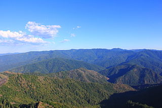
The Wild Rogue Wilderness is a wilderness area surrounding the 84-mile (135 km) Wild and Scenic portion of the Rogue River in southwestern Oregon, U.S. to protect the watershed. The wilderness was established in 1987 and now comprises 35,818 acres (14,495 ha). Because it spans part of the Rogue River-Siskiyou National Forest as well as the Medford district of the Bureau of Land Management (BLM), the Wild Rogue Wilderness is administered by both the BLM and the Forest Service.

Williams, Oregon Census-designated place in Oregon, United States

Williams is an unincorporated community and census-designated place (CDP) in Josephine County, Oregon, United States. As of the 2010 census it had a population of 1,072.

Rand Ranger Station United States historic place

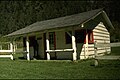
The Rand Ranger Station is a Bureau of Land Management compound consisting of eight historic buildings located in the Rogue River-Siskiyou National Forest in southwest Oregon. It was built by the United States Forest Service and the Civilian Conservation Corps as a district ranger station for the Galice Ranger District. The ranger station property was transferred to the Bureau of Land Management in 1970. Today, the ranger station office serves as a visitor center. The Rand Ranger Station is listed on the National Register of Historic Places.

Whisky Creek Cabin United States historic place

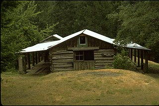
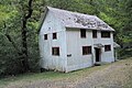
The Whisky Creek Cabin is a rustic log cabin located in southwest Oregon along the section of the Rogue River that is designated as a National Wild and Scenic River. It is the oldest remaining mining cabin in the Rogue River canyon. The Bureau of Land Management purchased the cabin and surrounding property in 1973. The Whisky Creek Cabin is listed on the National Register of Historic Places in 1975.

Trout Creek Mountains Mountain in United States of America

The Trout Creek Mountains are a remote, semi-arid Great Basin mountain range mostly in southeastern Oregon and partially in northern Nevada in the United States. The range's highest point is Orevada View Benchmark, 8,506 feet (2,593 m) above sea level, in Nevada. Disaster Peak, elevation 7,781 feet (2,372 m), is another prominent summit in the Nevada portion of the mountains.

Riddle Ranch United States historic place

The Riddle Brothers Ranch is a pioneer ranch complex located in the Steens Mountain Cooperative Management and Protection Area in Harney County in eastern Oregon, United States. It is a rare extant example of the small family ranch. The ranch is located on both sides of the Little Blitzen River on public land and is administered by the Bureau of Land Management.

Course of the Rogue River (Oregon)

The Rogue River in the U.S. state of Oregon begins at Boundary Springs on the border between Klamath and Douglas counties near the northern edge of Crater Lake National Park. The Rogue River flows generally west for 215 miles (346 km) from the Cascade Range through the Rogue River – Siskiyou National Forest and the Klamath Mountains to the Pacific Ocean at Gold Beach. Communities along its course include Union Creek, Prospect, Trail, Shady Cove, Gold Hill, and Rogue River, all in Jackson County; Grants Pass, and Galice in Josephine County, and Agness, Wedderburn and Gold Beach in Curry County. Significant tributaries include the South Fork Rogue River, Elk Creek, Bear Creek, the Applegate River, and the Illinois River. Arising at 5,320 feet (1,622 m) above sea level, the river loses more than 1 mile (1.6 km) in elevation by the time it reaches the Pacific.

Grave Creek (Oregon)

Grave Creek is a tributary, about 40 miles (64 km) long, of the Rogue River in southwestern Oregon in the United States.

Marial, Oregon Unincorporated community in Oregon, United States

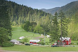
Marial is an unincorporated community and the site of a former post office in Curry County, Oregon, United States. Located along the Rogue River about 48 miles (77 km) from its mouth on the Pacific Ocean, the area was home to Takelma Indians, then to white and Karok settlers, before becoming part of a designated wilderness. Buildings preserved at the Rogue River Ranch pioneer farm complex, listed on the National Register of Historic Places, represent the former center of Marial. Nearby are the Tucker Flat Campground and a riverside lodge named Marial.

Little Applegate River river in the United States of America

The Little Applegate River is a 21-mile-long (34 km) tributary of the Applegate River located in the U.S. state of Oregon. It is part of the Rogue River watershed, draining approximately 113 square miles (293 km2) of Jackson County. Rising in the Siskiyou Mountains, the river flows generally northwest to meet the Applegate about 3 miles (4.8 km) northwest of Buncom and 2 miles (3.2 km) south of Ruch.

Big Butte Creek River in Oregon, United States of America

Big Butte Creek is a 12-mile-long (19 km) tributary of the Rogue River in the U.S. state of Oregon. It drains approximately 245 square miles (635 km2) of Jackson County. Its two forks, the North Fork and the South Fork, both begin high in the Cascade Range near Mount McLoughlin. Flowing predominantly west, they meet near the city of Butte Falls. The main stem flows generally northwest until it empties into the Rogue Falls was incorporated in 1911, and remains the only incorporated town within the watershed's boundaries.

References

  1. 1 2 3 4 5 "Rogue River Ranch", Oregon State Office, Bureau of Land Management, United States Department of Interior, Portland, Oregon, 11 March 2009.
  2. 1 2 3 4 5 6 7 8 9 10 "Rogue River Ranch National Historic Site", Medford District Office, Bureau of Land Management, United States Department of Interior, Medford, Oregon, August 2004.
  3. 1 2 McArthur, Lewis A. and Lewis L. McArthur, Oregon Geographic Names (Seventh Edition), Oregon Historical Society Press, Portland, Oregon, 2003.
  4. "Rogue River Ranch", National Register of Historic Places, www.nationalregisterofhistoricalplaces.com, 12 March 2009.
  5. "Rogue River Ranch" Archived 2011-07-26 at the Wayback Machine , Historical Places Database, www.hpdb.org, Oakland, California, 12 March 2009.
  6. "Rogue River Ranch Tackhouse Reconstruction", contract solicitation HAQ082042, Medford District, Bureau of Land Management, United States Department of Interior, Medford, Oregon, 25 July 2008.
  7. 1 2 "Historic Sites - Rogue River Ranch", Oregon State Office, Bureau of Land Management, United States Department of Interior, Portland, Oregon, 11 March 2009.