
Rosedale is a census-designated place (CDP) in Kern County, California, United States. The population was 14,058 at the 2010 census, up from 8,445 at the 2000 census. Formerly a country town 10 miles (16 km) west of Bakersfield, it is now surrounded by suburban housing and currently has the highest household income in Kern County, according to Census estimates.
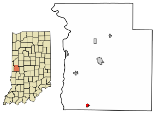
Rosedale is a town in Florida Township, Parke County, in the U.S. state of Indiana. The population was 725 at the 2010 census.

Rosedale is a neighbourhood in central Toronto, Ontario, Canada. It was formerly the estate of William Botsford Jarvis, and so named by his wife, granddaughter of William Dummer Powell, for the wild roses that grew there in abundance. It is located north of Downtown Toronto and is one of its oldest suburbs. In 2013, Rosedale was ranked the best neighbourhood in Toronto to live in by Toronto Life. According to Today’s Senior Magazine, it is known as the area where the city's 'old money' lives, and is home to some of Canada's richest and most famous citizens including Gerry Schwartz, founder of Onex Corporation, Adrienne Clarkson, the 26th Governor General of Canada, and her husband, the author John Ralston Saul, as well as David Thomson, 3rd Baron Thomson of Fleet of the Thomson Corporation, the latter of whom is the richest man in Canada.
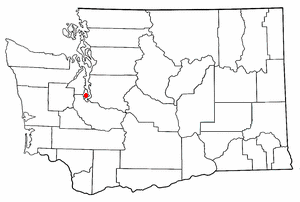
Raft Island is a private island and CDP located near the Pierce County community of Rosedale, Washington, United States. Gig Harbor, Washington is the nearest incorporated town, although unincorporated Artondale is much closer. The island features approximately 200 homes on 160 acres. All of these homes are served through the Gig Harbor post office.

Cleveland Park is a residential neighborhood in the Northwest quadrant of Washington, D.C. It is located at 38°56′11″N77°3′58″W and bounded approximately by Rock Creek Park to the east, Wisconsin and Idaho Avenues to the west, Klingle and Woodley Roads to the south, and Rodman and Tilden Streets to the north. Its main commercial corridor lies along Connecticut Avenue NW, where the eponymous Cleveland Park station of the Washington Metro's Red Line can be found; another commercial corridor lies along Wisconsin Avenue. The neighborhood is known for its many late 19th century homes and the historic Art Deco Uptown Theater. It is also home to the William L. Slayton House and the Park and Shop, built in 1930 and one of the earliest strip malls.

Rosedale is a neighborhood in New York City in the southeastern portion of the borough of Queens. The neighborhood, located along the southern part of Queens, borders Nassau County.
Ferry Island Provincial Park is a Class C provincial park in British Columbia that is located on the south side of the Fraser River northeast of Rosedale. This park is northwest of Bridal Falls, British Columbia and adjacent to the Agassiz-Rosedale Bridge. The Ferry Island Park was established in 1963, and it has an area of about 29 hectares.

Rosedale is an unincorporated community in central Pike Township, Madison County, Ohio, United States, and roughly thirty miles west of the city of Columbus.
Rosedale is a Dispersed Rural Community and unincorporated place located in the city of Kawartha Lakes, Ontario, Canada, 29 kilometres (18 mi) north-west of Lindsay. It is partly in geographic Fenelon Township and partly in Somerville Township, and is on the Rosedale River, part of the Trent–Severn Waterway, where that river drains Balsam Lake on its way to Cameron Lake.

Rosedale is a valley located almost in the centre of the North York Moors national park in North Yorkshire, England. The nearest town is Kirkbymoorside, 7 miles (11 km) to the south. Rosedale is surrounded by moorland. To the north-west sits Blakey Ridge at over 1,300 feet (400 m) above sea level. At Dale Head is the source of the River Seven, which flows down the valley to join the River Rye at Little Habton near Malton. At its southern end Rosedale is squeezed between Spaunton Moor and Hartoft Rigg, where the river flows out through Forestry Commission woodland before passing the village of Cropton to reach the plains of the Vale of Pickering.

The Shire of Rosedale was a local government area stretching between the towns of Traralgon and Sale, in the Gippsland region of Victoria, Australia. The shire covered an area of 2,276.6 square kilometres (879.0 sq mi), and existed from 1869 until 1994.
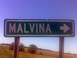
Malvina is an unincorporated community located in Bolivar County, Mississippi, United States, located approximately 3 miles (4.8 km) northwest of Symonds and approximately 9 miles (14 km) east of Rosedale.

Coal Bluff is an unincorporated community in northern Nevins Township, Vigo County, in the U.S. state of Indiana.
Manor is a ghost town in Washington Township, Montgomery County, Ohio, United States. Originally, Manor was founded as a railway stop between Centerville and Lytle on the Cincinnati, Lebanon, and Northern Railway. It was located on Social Row Road just one mile east of Dayton-Lebanon Pike.
Rosedale is an unincorporated community in Russell County, Virginia, United States. Rosedale is located at the junction of U.S. Route 19 and Virginia State Route 80 4.6 miles (7.4 km) south-southeast of Honaker. The community was founded in 1819. Rosedale has a post office with ZIP code 24280, which opened on February 26, 1897. Rosedale was named for the area's Rosedale Plantation; the plantation was either named after the couple that owned the property or named for a "rose valley". The community has also been known as Elway and Oaks Garage, the latter name coming from a service station in the settlement.
Rosedale is an unincorporated community in Marion County, Oregon, United States. It is located just south of Salem, in the Salem Hills. It is a part of the Salem Metropolitan Statistical Area.
Rosedale is a census-designated place in Grant County, New Mexico, United States. Its population was 394 as of the 2010 census. Rosedale was established in 1882 by prospector Jack Richardson and his wife Rose.
Rosedale is a ghost town in Boyd County, Nebraska, United States.
Riverton is a ghost town in Bolivar County, Mississippi, United States.

Rosedale is a suburb on the North Shore of Auckland, New Zealand. It is located 12 kilometres north of the city centre, to the south of the suburbs of Pinehill and Albany. It is under the local governance of the Auckland Council. Northern Rosedale is also known by the name Upper Harbour.

