
Manchuria refers to a region in Northeast Asia encompassing the entirety of present-day Northeast China or, historically, those areas combined with parts of the Russian Far East. Its definition may refer to varying geographical extents as following: the Chinese provinces of Heilongjiang, Jilin, and Liaoning but broadly also including the eastern Inner Mongolian prefectures of Hulunbuir, Hinggan, Tongliao, and Chifeng, collectively known as Northeast China. Historically included homeland of the Jurchens and later their descendants Manchus, which was controlled in whole by Qing China prior to the Amur Annexation in 1858–1860, when parts of the historical region were ceded to the Russian Empire. The two areas involved are Priamurye between the Amur River and the Stanovoy Range to the north, and Primorye which runs down the Pacific coast from the Amur mouth to the Korean border, sometimes including the island of Sakhalin- collectively known as Russian Manchuria.
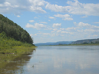
The Amur, or Heilong Jiang, is the world's tenth longest river, forming the border between the Russian Far East and Manchuria/Northeastern China. The Amur proper is 2,824 kilometres (1,755 mi) long, and has a drainage basin of 1,855,000 km2 (716,000 sq mi). Including its source river Argun, it is 4,444 km (2,761 mi) long. The largest fish species in the Amur is the kaluga, attaining a length as great as 5.6 metres (18 ft). The river basin is home to a variety of large predatory fish such as northern snakehead, Amur pike, taimen, Amur catfish, predatory carp and yellowcheek, as well as the northernmost populations of the Amur softshell turtle and Indian lotus.

Khabarovsk Krai is a federal subject of Russia. It is located in the Russian Far East and is administratively part of the Far Eastern Federal District. The administrative centre of the krai is the city of Khabarovsk, which is home to roughly half of the krai's population and the largest city in the Russian Far East. Khabarovsk Krai is the fourth-largest federal subject by area, and had a population of 1,343,869 as of 2010.

The Russian Far East is a region in Northeast Asia. It is the easternmost part of Russia and the Asian continent; and is administered as a part of the Far Eastern Federal District, which is located between Lake Baikal in eastern Siberia and the Pacific Ocean. The area's largest city is Khabarovsk, followed by Vladivostok. The region shares land borders with the countries of Mongolia, China, and North Korea to its south, as well as maritime boundaries with Japan to its southeast, and with the United States along the Bering Strait to its northeast.

The Tungusic languages form a language family spoken in Eastern Siberia and Manchuria by Tungusic peoples. Many Tungusic languages are endangered. There are approximately 75,000 native speakers of the dozen living languages of the Tungusic language family. The term "Tungusic" is from an exonym for the Evenk people (Ewenki) used by the Yakuts ("tongus"). It was borrowed into Russian as "тунгус", and ultimately transliterated into English as "Tungus".

Manchuria is a region in East Asia. Depending on the definition of its extent, Manchuria can refer either to a region falling entirely within present-day China, or to a larger region today divided between Northeast China and the Russian Far East. To differentiate between the two parts following the latter definition, the Russian part is also known as Russian Manchuria, while the Chinese part is known as Manchuria.

The Treaty of Aigun was an 1858 treaty between the Russian Empire and the Qing dynasty that established much of the modern border between the Russian Far East and China by ceding much of Manchuria, now known as Northeast China. Negotiations began after China was threatened with war on a second front by Governor-General of the Far East Nikolay Muraviev when China was suppressing the Taiping Rebellion. It reversed the Treaty of Nerchinsk (1689) by transferring the land between the Stanovoy Range and the Amur River from the Qing Dynasty to the Russian Empire. Russia received over 600,000 square kilometers (231,660 sq mi) of what became known as Russian Manchuria.

The Treaty of Nerchinsk of 1689 was the first treaty between the Tsardom of Russia and the Qing dynasty of China. The Russians gave up the area north of the Amur River as far as the Stanovoy Range and kept the area between the Argun River and Lake Baikal. This border along the Argun River and Stanovoy Range lasted until the Amur Annexation via the Treaty of Aigun in 1858 and the Convention of Peking in 1860. It opened markets for Russian goods in China, and gave Russians access to Chinese supplies and luxuries.

Green Ukraine, also known as Zelenyi Klyn or Zakytaishchyna, is a historical Ukrainian name for the land in the Russian Far East area between the Amur River and the Pacific Ocean, an area roughly corresponding to Russian Manchuria.

Primorskaya Oblast was an administrative division of the Russian Empire and the early Russian SFSR, created on October 31, 1856 by the Governing Senate. The name of the region literally means "Maritime" or "Coastal." The region was established upon a Russian conquest of Daur people that used to live along Amur River. Before the Russian conquest of Russian Manchuria, the territory belonged to the Chinese region of Manchuria.

Count Nikolay Nikolayevich Muravyov-Amursky was a Russian general, statesman and diplomat, who played a major role in the expansion of the Russian Empire into the Amur River basin and to the shores of the Sea of Japan.

Tungusic peoples are an ethno-linguistic group formed by the speakers of Tungusic languages. They are native to Siberia and Northeast Asia.
Yishan, courtesy name Jingxuan, was a Manchu lesser noble and official of the Qing dynasty. He is best known for his failure to defend Guangzhou (Canton) from British forces during the First Opium War, and for signing the treaties of Kulja and Aigun with the Russian Empire in 1851 and 1858 respectively.

Albazino is a village (selo) in Skovorodinsky District of Amur Oblast, Russia, noted as the site of Albazin (Албазин), the first Russian settlement on the Amur River.

The Sino-Russian border conflicts (1652–1689) were a series of intermittent skirmishes between the Qing dynasty of China, with assistance from the Joseon dynasty of Korea, and the Tsardom of Russia by the Cossacks in which the latter tried and failed to gain the land north of the Amur River with disputes over the Amur region. The hostilities culminated in the Qing siege of the Cossack fort of Albazin in 1686 and resulted in the Treaty of Nerchinsk in 1689 which gave the land to China.

The Muravyov-Amursky Peninsula is a peninsula in Primorsky Krai, Russia, located in the Peter the Great Gulf of the Sea of Japan. Vladivostok, the administrative center of Primorsky Krai, is located on the southern tip of the peninsula.
Chuang Guandong is descriptive of the rush of Han people into Manchuria, mainly from the Shandong Peninsula and Zhili, during the hundred-year period beginning in the last half of the 19th century. During the first two centuries of the Manchu-led Qing dynasty, this part of China, the traditional homeland of the ruling Manchus, was, with few exceptions, closed to settlement by Han civilians, with only certain Manchu bannermen, Mongol bannermen, and Han bannermen allowed in. The Manchuria/Northeast China area now has an overwhelmingly Han population.
The Amur Annexation was the annexation of the southeast corner of Siberia by the Russian Empire in 1858–1860 through a series of unequal treaties forced upon the Qing dynasty of China. The two areas involved are Priamurye between the Amur River and the Stanovoy Range to the north, and Primorye which runs down the coast from the Amur mouth to the Korean border, including the island of Sakhalin. The territory now known as Russian Manchuria, part of the wider region called Manchuria, was formerly under the sovereignty of Qing China.
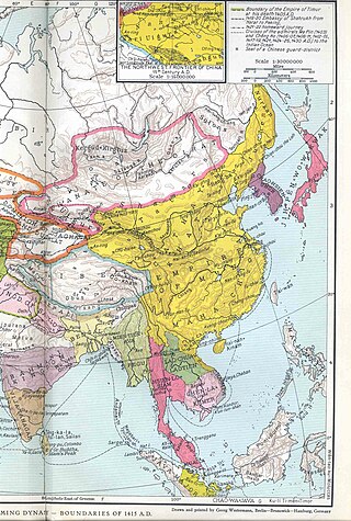
Manchuria under Ming rule refers to the domination of the Ming dynasty over Manchuria, including Northeast China and Russian Manchuria. The Ming rule of Manchuria began with its conquest of Manchuria in the late 1380s after the fall of the Mongol-led Yuan dynasty, and reached its peak in the early 15th century with the establishment of the Nurgan Regional Military Commission, but the Ming power waned considerably in Manchuria after that. Starting in the 1580s, the Jianzhou Jurchen chieftain Nurhaci began to take control of most of Manchuria over the next several decades, and in 1616 he established the Later Jin. The Qing dynasty established by his son Hong Taiji would eventually conquer the Ming and take control of Southern China.

Imperial Russia was a participant of the Chinese Opium Wars, more specifically in the second and third wars which occurred in 1856-1860. Russia played a role of mediator, being both an ally with Britain, France, and the United States and negotiator with the elites of the Qing dynasty. Throughout the whole war period Russia provided minimal amount of military aid and used diplomatic power to present its interests in the conflict. As a result of the ratified agreements in 1860 Russia received former Manchurian lands along the Ussuri river and increased its economical influence on China.
