The River Camel is a river in Cornwall, England. It rises on the edge of Bodmin Moor and with its tributaries its catchment area covers much of North Cornwall. The river flows into the eastern Celtic Sea between Stepper Point and Pentire Point having covered about 30 miles (50 km) making it the second longest river wholly in Cornwall. The river is tidal upstream to Egloshayle and is popular for sailing, birdwatching and fishing. The name Camel comes from the Cornish language for 'the crooked one', a reference to its winding course. Historically the river was divided into three named stretches. Heyl was the name for the estuary up to Egloshayle, the River Allen was the stretch between Egloshayle and Trecarne, whilst the Camel was reserved for the stretch of river between its source and Trecarne.

Perranporth is a seaside resort town on the north coast of Cornwall, England, United Kingdom. It is 2.1 miles east of the St Agnes Heritage Coastline, and around 7 miles south-west of Newquay. Perranporth and its 2 miles (3 km) long beach face the Atlantic Ocean. It has a population of 3,066, and is the largest settlement in the civil parish of Perranzabuloe. It has an electoral ward in its own name whose population was 4,270 in the 2011 census.

The Bodmin and Wenford Railway is a 6 miles 12 chains (9.9 km) heritage railway at Bodmin in Cornwall, England. Its headquarters are at Bodmin General railway station and it connects with the national rail network at Bodmin Parkway.

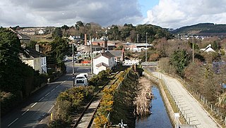
Wadebridge is a town and civil parish in north Cornwall, England, United Kingdom. The town straddles the River Camel five miles upstream from Padstow. The permanent population was 6,222 in the census of 2001, increasing to 7,900 in the 2011 census. There are two electoral wards in the town. Their total population is 8,272.

The Bodmin and Wadebridge Railway was a railway line opened in 1834 in Cornwall, England, United Kingdom. It linked the quays at Wadebridge with the town of Bodmin and also to quarries at Wenfordbridge. Its intended traffic was minerals to the port at Wadebridge and sea sand, used to improve agricultural land, inwards. Passengers were also carried on part of the line.

The Great Western Railway (GWR) 1366 Class is a class of 0-6-0 pannier tank steam locomotives built in 1934. They were a useful design and because of their light weight and short wheelbase and were often used on dockside branches or other lines with sharp curvatures.
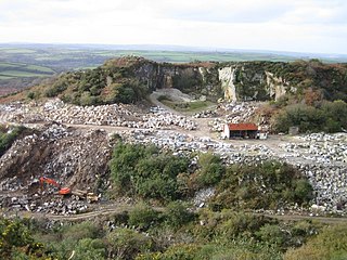
De Lank Quarries is an active quarry and a 54-acre geological Site of Special Scientific Interest in St Breward parish, north Cornwall, England, UK. The quarry, which received its SSSI notification in 1994, takes its name from the nearby De Lank river. The quarry produces typical biotite granites and are of such quality that a slab now forms the base section of the reception desk at the Geological Society of London. Other notable structures built of De Lank granite are the fourth Eddystone Lighthouse, 1882; the Royal Opera House in Covent Garden, London and the New Parliamentary Building in Whitehall, London
St Merryn is a civil parish and village in north Cornwall, England, United Kingdom. It is about 3.5 miles (5.6 km) south of the fishing port of Padstow and 11 miles (18 km) northeast of the coastal resort of Newquay.
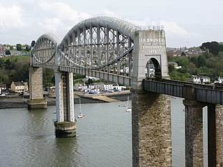
The Cornish Main Line is a railway line in Cornwall and Devon in the United Kingdom. It runs from Penzance to Plymouth, crossing from Cornwall into Devon over the Royal Albert Bridge at Saltash.

The North Cornwall Railway (NCR) also known as the North Cornwall Line, was a standard gauge railway line running from Halwill in Devon, to Padstow in Cornwall, at a distance of 49 miles 67 chains via Launceston, Camelford and Wadebridge. The line was opened in late 19th century by the North Cornwall Railway Company with support throughout much of its construction and existence by the London and South Western Railway (LSWR).

Wadebridge railway station was a railway station that served the town of Wadebridge in Cornwall, England. It was on the Bodmin and Wadebridge Railway.
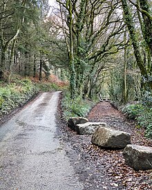
There are eight disused railway stations between Wadebridge and Bodmin North on the former Bodmin and Wadebridge Railway in Cornwall, in the United Kingdom, with ten other closed sidings on the branches to Ruthern Bridge and Wenfordbridge. The section from Boscarne Junction to Bodmin General is currently part of the Bodmin and Wenford Steam Railway; the line from Wadebridge to Wenfordbridge is now part of the Camel Trail, and the line to Ruthern Bridge can be followed for much of its length as it runs parallel to a public road.

Withiel is a civil parish and village in mid Cornwall, England, United Kingdom. The parish of Withiel is between the parishes of St Breock, Lanivet, Roche and St Wenn. The name Withiel comes from the Cornish word Gwydhyel, meaning "wooded place". The parish contains the hamlets of Withielgoose, Retire and Tregawne; the parish had a total population of about 300 in 1824.
The evolution of transport in Cornwall has been shaped by the county's strong maritime, mining and industrial traditions and much of the transport infrastructure reflects this heritage.

Pendoggett is a village in the civil parish of St Kew, Cornwall, England, United Kingdom. It is a linear village stradling the B3314 Wadebridge to Delabole road about five miles (8 km) northwest of Wadebridge, four miles (6.5 km) southeast of Delabole, and two miles (3 km) southeast of Port Isaac.
Lank is a settlement in Cornwall, England, United Kingdom. It is situated approximately one mile (1.6 km) south of St Breward and six miles (10 km) east-northeast of Wadebridge in St Breward civil parish. It is in the civil parish of Blisland.

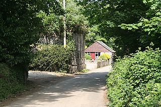
Wenfordbridge, or Wenford Bridge, is a hamlet some 6 miles (9.7 km) north of Bodmin and on the western flank of Bodmin Moor, in Cornwall, England. It takes its name from an old granite bridge over the River Camel, and lies on the border between the parishes of St Breward and St Tudy.
Mulberry Downs Quarry is a disused opencast tin mine in Cornwall, England, UK. Today the site is described as a 'chasm' being a steep or sheer-sided pit 700 foot (210 m) long and up to 100 foot (30 m) deep, and the quarry and immediate surroundings are heavily wooded. The quarry was designated as a Site of Special Scientific Interest (SSSI) in 1973 for its geological interest.
Presented below is an alphabetical index of articles related to Cornwall: