Sablan, Benguet Last updated January 01, 2026 Municipality in Benguet, Philippines
Municipality in Cordillera Administrative Region, Philippines
Sablan , officially the Municipality of Sablan (Ilocano : Ili ti Sablan Tagalog : Bayan ng Sablan municipality in the province of Benguet , Philippines . According to the 2024 census, it has a population of 12,436 people. [ 5]
Etymology The term "Sablan" was derived from the local word "Sabdang", a local tree which thrived in the area. [ 6]
History Sablan was created officially as a municipal district on July 1, 1927, under Executive Order No. 61 dated May 17, 1927 by then American Governor General Leonard Wood .
Geography The Municipality of Sablan is at the mid-western tip of Benguet. It is bounded by Kapangan on the north, Tublay on the northeast, La Trinidad on the east, Baguio in the southeast, Tuba in the south, Aringay on the southwest, and Burgos to the west.
According to the Philippine Statistics Authority , the municipality has a land area of 105.63 square kilometres (40.78 sq mi) [ 7] constituting 3.81% of the 2,769.08-square-kilometre- (1,069.15 sq mi) total area of Benguet.
Sablan is situated 22.62 kilometres (14.06 mi) from the provincial capital La Trinidad , and 258.68 kilometres (160.74 mi) from the country's capital city of Manila .
Barangays Sablan is politically subdivided into 8 barangays . [ 8] Each barangay consists of puroks and some have sitios .
PSGC Barangay Population ±% p.a. 2024 [ 9] 2010 [ 10] 141112002 Bagong 5.8% 719 764 ▾ −0.44% 141112003 Balluay 5.4% 667 507 ▴ 2.03% 141112004 Banangan 16.0% 1,994 1,756 ▴ 0.93% 141112005 Banengbeng 7.1% 889 1,108 ▾ −1.60% 141112006 Bayabas 19.8% 2,465 2,068 ▴ 1.29% 141112007 Kamog 12.0% 1,488 1,064 ▴ 2.48% 141112010 Pappa 5.0% 624 594 ▴ 0.36% 141112011 Poblacion 22.0% 2,742 2,650 ▴ 0.25% Total 12,436 11,588 ▴ 0.52%
Climate Climate data for Sablan, Benguet Month Jan Feb Mar Apr May Jun Jul Aug Sep Oct Nov Dec Year Mean daily maximum °C (°F) 22 23 24 25 24 23 21 21 21 22 23 22 23 Mean daily minimum °C (°F) 12 12 14 16 17 16 16 16 16 15 14 12 15 Average precipitation mm (inches) 15 16 24 33 102 121 177 165 144 170 56 23 1,046 Average rainy days 6.3 6.6 9.5 12.8 20.6 23.5 25.4 23.4 23.2 21.4 14.0 8.2 194.9 Source: Meteoblue [ 11]
Demographics Population census of Sablan Year ±% p.a. 1939 2,930 — 1948 2,786 −0.56% 1960 4,741 +4.53% 1970 5,681 +1.82% 1975 7,345 +5.29% 1980 7,900 +1.47% 1990 8,440 +0.66% 1995 9,170 +1.57% 2000 9,652 +1.10% 2007 10,890 +1.68% 2010 10,511 −1.28% 2015 11,457 +1.65% 2020 11,588 +0.24% 2024 12,436 +1.71% Source: Philippine Statistics Authority [ 12] [ 13] [ 10] [ 14] [ 15]
In the 2024 census, Sablan had a population of 12,436 people. [ 16] The population density was 120 inhabitants per square kilometre (310/sq mi) .
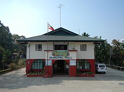
Government Local government Sablan, belonging to the lone congressional district of the province of Benguet , is governed by a mayor designated as its local chief executive and by a municipal council as its legislative body in accordance with the Local Government Code. The mayor, vice mayor, and the councilors are elected directly by the people through an election which is being held every three years.
Elected officials Members of the Municipal Council [ 25] Position Name Congressman Eric G. Yap Mayor Alfredo B.Dacumos Jr. Vice-Mayor Arthur C. Baldo Councilors Johny C. Cutay Harold H. Busoy Cesar B. Calado Romeo P. Amboy Jefferson I. Carame Cornelio I. Almacen Jerry W. Olanio Arthur F. De Leon
Education The Sablan Schools District Office governs all educational institutions within the municipality. It oversees the management and operations of all private and public, from primary to secondary schools. [ 26]
Transportation A major road within Sablan include Naguilian Road (formerly Quirino Highway ).
References ↑ Municipality of Sablan | (DILG) ↑ "2015 Census of Population, Report No. 3 – Population, Land Area, and Population Density" (PDF) . Philippine Statistics Authority . Quezon City, Philippines. August 2016. ISSN 0117-1453 . Archived (PDF) from the original on May 25, 2021. Retrieved July 16, 2021 . ↑ "2024 Census of Population (POPCEN) Population Counts Declared Official by the President" . Philippine Statistics Authority. 17 July 2025. Retrieved 18 July 2025 . ↑ "PSA Releases the 2021 City and Municipal Level Poverty Estimates" . Philippine Statistics Authority. 2 April 2024. Retrieved 28 April 2024 . ↑ "2024 Census of Population (POPCEN) Population Counts Declared Official by the President" . psa.gov.ph . July 17, 2024. Retrieved November 15, 2025 . ↑ "Municipality of Sablan, Benguet profile" . DILG - CAR . Department of the Interior and Local Government (Philippines). Retrieved 16 September 2014 . ↑ "Province: Abra" . PSGC Interactive . Quezon City, Philippines: Philippine Statistics Authority . Retrieved 25 August 2025 . ↑ "Municipal: Sablan, Benguet" . PSGC Interactive . Quezon City, Philippines: Philippine Statistics Authority . Retrieved 8 January 2016 . ↑ Census of Population (2020). "Cordillera Administrative Region (CAR)" . Total Population by Province, City, Municipality and Barangay . Philippine Statistics Authority . Retrieved 8 July 2021 . 1 2 Census of Population and Housing (2010). "Cordillera Administrative Region (CAR)" (PDF) . Total Population by Province, City, Municipality and Barangay . National Statistics Office . Retrieved 29 June 2016 . ↑ "Sablan: Average Temperatures and Rainfall" . Meteoblue. Retrieved 21 March 2020 . ↑ "2024 Census of Population (POPCEN) Population Counts Declared Official by the President" . Philippine Statistics Authority. 17 July 2025. Retrieved 18 July 2025 . ↑ Census of Population (2015). "Cordillera Administrative Region (CAR)" . Total Population by Province, City, Municipality and Barangay . Philippine Statistics Authority . Retrieved 20 June 2016 . ↑ Censuses of Population (1903–2007). "Cordillera Administrative Region (CAR)" . Table 1. Population Enumerated in Various Censuses by Province/Highly Urbanized City: 1903 to 2007 National Statistics Office . ↑ "Province of Abra" . Municipality Population Data . Local Water Utilities Administration Research Division. Retrieved 17 December 2016 . ↑ "2024 Census of Population (POPCEN) Population Counts Declared Official by the President" . Philippine Statistics Authority. 17 July 2025. Retrieved 18 July 2025 . ↑ "Poverty incidence (PI):" . Philippine Statistics Authority. Retrieved December 28, 2020 . ↑ "Estimation of Local Poverty in the Philippines" (PDF) . Philippine Statistics Authority. 29 November 2005. ↑ "2003 City and Municipal Level Poverty Estimates" (PDF) . Philippine Statistics Authority. 23 March 2009. ↑ "City and Municipal Level Poverty Estimates; 2006 and 2009" (PDF) . Philippine Statistics Authority. 3 August 2012. ↑ "2012 Municipal and City Level Poverty Estimates" (PDF) . Philippine Statistics Authority. 31 May 2016. ↑ "Municipal and City Level Small Area Poverty Estimates; 2009, 2012 and 2015" . Philippine Statistics Authority. 10 July 2019. ↑ "PSA Releases the 2018 Municipal and City Level Poverty Estimates" . Philippine Statistics Authority. 15 December 2021. Retrieved 22 January 2022 . ↑ "PSA Releases the 2021 City and Municipal Level Poverty Estimates" . Philippine Statistics Authority. 2 April 2024. Retrieved 28 April 2024 . ↑ "2019 National and Local Elections" (PDF) . Commission on Elections . Retrieved March 12, 2022 . ↑ "Masterlist of Schools" (PDF) . Department of Education . January 15, 2021. Retrieved May 10, 2025 . ↑ "Masterlist of Public Elementary Schools for the School year 2012- 2013" (XLSX ) . Department of Education (Philippines) , July 15, 2013. Retrieved 28 December 2014 . 1 2 "Masterlist of Secondary Schools (School Year 2013- 2014)" . Department of Education (Philippines) , July 4, 2013. Archived from the original (XLSX ) on 1 July 2014. Retrieved 20 November 2014 . 1 2 "Masterlist of Public Schools SY 2013-2014" (XLSX ) . Department of Education (Philippines) , 22 October 2014. Retrieved 28 December 2014 . External links Media related to Sablan, Benguet at Wikimedia Commons
Places adjacent to Sablan, Benguet
This page is based on this
Wikipedia article Text is available under the
CC BY-SA 4.0 license; additional terms may apply.
Images, videos and audio are available under their respective licenses.