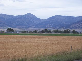
The Bridger Range, also known as the Bridger Mountains, is a subrange of the Rocky Mountains in southwestern Montana in the United States. The range runs mostly in a north–south direction between Bozeman and Maudlow. It is separated from the Gallatin Range to the south by Bozeman Pass; from the Horseshoe Hills to the west by Dry Creek; from the Crazy Mountains to the east by the Shields River valley; and from the Big Belt Mountains to the north by Sixteen Mile Creek. The highest point in the Bridger Range is Sacagawea Peak, which is visible to the northeast from Bozeman.

Mount Charleston, including Charleston Peak at 11,916 feet (3,632 m), is the highest mountain in both the Spring Mountains and Clark County, in Nevada, United States. It is the eighth-highest mountain in the state. Well separated from higher peaks by large, low basins, Charleston Peak is the most topographically prominent peak in Nevada, and the eighth-most-prominent peak in the contiguous United States. It is one of eight ultra-prominent peaks in Nevada. It is located about 35 miles (56 km) northwest of Las Vegas within the Mount Charleston Wilderness, which is within the Spring Mountains National Recreation Area of the Humboldt–Toiyabe National Forest.

Wheeler Peak is the tallest mountain in the Snake Range and in White Pine County, in Nevada, United States. The summit elevation of 13,065 feet (3,982 m) makes it the second-highest peak in Nevada, just behind Boundary Peak. With a topographic prominence of 7,563 feet (2,305 m), Wheeler Peak is the most topographically prominent peak in White Pine County and the second-most prominent peak in Nevada, just behind Mount Charleston. The mountain is located in Great Basin National Park and was named for George Wheeler, leader of the Wheeler Survey of the late 19th century.

Kings Peak is the highest peak in the U.S. state of Utah, with an elevation of 13,528 feet (4,123 m) NAVD 88.

White Mountain Peak, at 14,252-foot (4,344 m), is the highest peak in the White Mountains of California, the highest peak in Mono County, and the third highest peak in the state after Mount Whitney and Mount Williamson.

Mount Nebo is the southernmost and highest mountain in the Wasatch Range of Utah, in the United States. Named after the biblical Mount Nebo overlooking Israel, which is said to be the place of Moses' death, it is the centerpiece of the Mount Nebo Wilderness, inside the Uinta National Forest.

Pusch Ridge is the most prominent feature in the Pusch Ridge Wilderness Area of the Santa Catalina Mountains, managed by the Coronado National Forest north of Tucson, Arizona, in the United States.

Telescope Peak is the highest point within Death Valley National Park, in the U.S. state of California. It is also the highest point of the Panamint Range, and lies in Inyo County. From atop this desert mountain one can see for over one hundred miles in many directions, including west to Mount Whitney, and east to Charleston Peak. The mountain was named for the great distance visible from the summit.

Four Peaks is a prominent landmark on the eastern skyline of Phoenix. Part of the Mazatzal Mountains, it is located in the Four Peaks Wilderness in the Tonto National Forest, 40 miles (64 km) east-northeast of Phoenix. In winter, Four Peaks offers much of the Phoenix metro area a view of snow-covered peaks. Four Peaks is the site of an amethyst mine that produces top-grade amethyst.

Big Bald Mountain is the highest peak in Gilmer County, Georgia, U.S. and is in the Rich Mountain Wilderness, which is administered as a component of the Chattahoochee National Forest.

Mount Hancock is a mountain in Grafton County, New Hampshire, named after John Hancock (1737–1793), one of the Founding Fathers of the United States.

Mount Tripyramid is a mountain located in Grafton County, New Hampshire. Part of the Sandwich Range of the White Mountains, it has three distinct peaks – North, Middle, and South – along its mile-long summit ridge. North, at 4,160 ft (1,270 m), is the highest. Scaur Peak and The Fool Killer are subsidiary peaks to the northwest and northeast. To the southeast, Tripyramid is flanked by The Sleepers.

Deseret Peak is the highest peak in the Stansbury Mountains with an elevation of 11,035 ft. It is located in the Deseret Peak Wilderness area west of Grantsville, Utah and east of Skull Valley Indian Reservation. It is the fourth most topographically prominent peak in the state of Utah. The site is a popular destination for hikers and backcountry skiers as the area is a contrast of the alpine wilderness with the surrounding desert basin. The trail that leads to the peak is easily accessible from Salt Lake City. The mountain offers views of the Bonneville Salt Flats, the Great Salt Lake, and the surrounding towns and mountain ranges. On a clear day, it is possible to see Mount Nebo, the highest peak in the adjacent Wasatch Mountains.

The Gallatin Range is a mountain range of the Rocky Mountains, located in the U.S. states of Montana and Wyoming. It includes more than 10 mountains over 10,000 feet (3,000 m). The highest peak in the range is Electric Peak at 10,969 feet (3,343 m).

Mount Helen is located in the Wind River Range in the U.S. state of Wyoming. The peak is the fourth highest peak in the range and the fifth tallest in Wyoming. The summit is located in the Bridger Wilderness of Bridger-Teton National Forest, immediately west of the Continental Divide. The eastern flanks of the mountain are covered in snowfields and glaciers, including Helen and Sacagawea Glaciers, all of which are in the Fitzpatrick Wilderness of Shoshone National Forest.
Mount Sacagawea is the eighth-highest peak in the U.S. state of Wyoming and the seventh-highest in the Wind River Range. It was named after Sacagawea, the young Lemhi Shoshone woman who accompanied the Lewis and Clark Expedition as an interpreter and guide. The Upper Fremont Glacier is located southeast and the Sacagawea Glacier is northeast of the mountain. Straddling the Continental Divide, Mount Sacagawea is one mile (1.6 km) northwest of Fremont Peak.

Sacajawea Peak is a peak in the Wallowa Mountains, in the U.S. state of Oregon. It is in the Eagle Cap Wilderness and the Wallowa–Whitman National Forest.

McDonald Peak is located in the U.S. state of Montana and is the highest peak in the Mission Mountains. McDonald Peak is situated within the Flathead Indian Reservation. The peak has the second greatest topographic prominence of all summits within Montana and is almost 80 miles (130 km) away from the next highest mountain in the state. McDonald Glacier is on the north slope of the peak.

Bears Tooth is a mountain spire in the Beartooth Mountains in the U.S. state of Montana. The peak is in the Absaroka-Beartooth Wilderness in Custer National Forest, and is adjacent to Beartooth Mountain. Bears Tooth is the namesake for numerous other points in the region and the Beartooth Mountains themselves. Known by the Native American Crow as "Na Piet Say", translated as bears tooth, the spire can be seen from the Beartooth Highway.
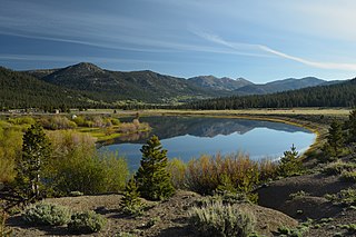
Hope Valley is a broad mountain valley in Alpine County, California, located on the eastern slope of the Sierra Nevada to the northeast of Carson Pass and south of Lake Tahoe. The valley served as a major thoroughfare for the passage of settlers and emigrants to and from California during the Gold Rush era. Sitting at an elevation of just above 7,000 feet (2,100 m) and framed by peaks reaching over 10,000 feet (3,000 m) high, Hope Valley is known for its wide vistas, fly fishing, fall colors, and winter activities.


