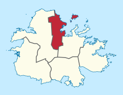
Saint George, Antigua and Barbuda

Last updated

Parish of Saint George
SVRStadium2.png
V.C. Bird International Airport.png
Maiden Island Reef Balls.jpg
Saint George, Antigua and Barbuda - panoramio (1).jpg
(from top: left to right) Sir Vivian Richards Stadium, V.C. Bird International Airport, Reef Balls on Maiden Island, Dutchman Bay
Saint George in Antigua and Barbuda (cropped).svg
Country Antigua and Barbuda
Pre-establishment entityDivision of New North Sound
EstablishmentJanuary 22, 1725;299 years ago (1725-01-22)
Capital Fitches Creek
Largest city Piggotts
Government
  MPs Algernon Watts, Asot Michael, Charles Fernandez
Population
 (2018)
  Total8,817 [1]
Time zone UTC-4 (AST)

Saint George, officially the Parish of Saint George, is a parish of Antigua and Barbuda on the island of Antigua. Saint George borders Saint Peter to the southeast, and Saint John to the west and south. Saint George is mostly farmland and savanna in the south, dense forest in the Blackman's Peninsula area, marshland in the Fitches Creek area, and dense forest in the northwest. It is the smallest parish in Antigua and Barbuda, and the parish capital is Fitches Creek. The largest city in the parish is Piggotts. Saint George is the newest parish, splitting from the parish of Saint Peter in 1725. It had a population of 7,976 in 2011.

Contents

Saint George is the most prosperous parish in the country, with the communities of Fitches Creek and Coolidge being classified as one of the six neighbourhoods in the country to have high-income status. [2] The neighbourhoods of Fitches Creek, Coolidge, Airport all had the top fifteen living conditions indexes in 2008. [3] Saint George's prosperity has been the result of having one of the most modern airports in the Caribbean, V. C. Bird International Airport, the headquarters of the Antigua and Barbuda Defence Force, Camp Blizzard, multiple universities such as the American University of Antigua and the Antigua and Barbuda International Institute of Technology, the Sir Vivian Richards Stadium, and the former Antigua Air Station. This economic prosperity is spread throughout the parish, with both the northern region of the parish, and the southern region, having important and modern facilities. [4] [5] [6]

Long Island and Maiden Island are legally parts of the parish of Saint George, however, statistically, the three residents on Long Island in 2011 were counted as living in Saint Peter, and politically, Long Island and Maiden Island are parts of the St. Peter constituency. [7]

Saint George does not have many tourist attractions and beaches, and instead generates much of its revenue from the V.C. Bird International Airport, the only airport in Antigua, and the 20,000-capacity Sir Vivian Richards Cricket Stadium, which co-hosted the 2007 Cricket World Cup. Due to the many international universities hosted in Saint George, Saint George has a large international student population. Due to Saint George hosting Antigua's only airport, Saint George also hosts the only air-links into Barbuda and Montserrat. [8] [9]

The Division of New North Sound, which is now the only division in Saint George, split from Saint Peter with the primary objective of providing for their parish church and having their own parish vestry. Historically, the majority of the parish's lands were used for agricultural purposes. Numerous historical relics from the parish can still be seen today, including the Blackman’s [10] and Judge Blizzard’s plantations. [11]

History

Archaic age and ceramic age in Winthrope's Bay

From the earliest days of colonization, pre-Columbian peoples made extensive use of Winthorpe's Bay. There are patches of Archaic Age flakes and lithic debitage scattered over many kilometers of the waterfront, together with deposits of shellfish, which are the leftovers of prehistoric meals. In 1997, a shoreline archaeological survey was carried out. Three sites from the Ceramic Age were identified and examined during this search. One meter below the surface, Saladoid pottery was found in GE-06 (Winthorpe's West). But the site is essentially a post-Saladoid site. The second and biggest site is GE-01, a sizable post-Saladoid and Archaic munti-component site (Winthorpe's East). Here was found a lithic workshop, or flint processing facility. There were two archeological excavations in 1997 and 2002. Barnacle Point, and the Archaic sites, GE-9 and 10, were destroyed by land development in the summer of 2003. Studies in this field are ongoing. [12]

Colonial period

The parish of Saint George was created on 22 January 1725 after An Act for dividing the Parish of Saint Peter in the said Island; and for erecting a new Parish, to be called the Parish of Saint George passed the Assembly on 10 January 1725, and the Council on the same day. The parish was created due to the parish of Saint Peter being too large to support the parish of Saint George. The parish was governed by twelve vestry-men. [13]

During the times of slavery, Saint George was divided into twenty-two slave plantations. [14]

World War II and U.S. interest

The United States sought to establish an Army Air Base at Coolidge, Saint George, and a Naval Air Station at Crabbs, Saint Peter. The U.S. flag was hoisted on 21 March 1941, even though the Antigua agreement was not signed until 28 May and the entire lease agreement not until 27 March 1941. Even earlier, on 4 February, work had started building the Naval Air Station, and on 17 March, a detachment of fifty Marines, the first American military personnel, arrived. On 13 May, construction on the bigger Army Air Base started. [15] The settlement of Winthorpes and the MacDonalds' estate house at High Point were included in the borders of the region selected for the Army base, which was primarily made up of canefield, scrub, and mango swamp. [16]

Construction on the base did not conclude until the spring of 1942, in part due to the lengthy process of relocating the village and its residents. However, both bases had started up immediately using makeshift facilities, with the first plane landing at Coolidge on 6 June 1941, and the first seaplane arriving at Crabbs, Saint Peter on 25 June. When the air bases diminished in importance, the army air base was converted into the Coolidge Airport, later renamed the V.C. Bird International Airport. [16]

Geography

Communities in the parish Communities of Saint George.svg
Communities in the parish

Saint George is mostly flat, being dominated by grasslands in the south, marshland in the centre, and forest in the north. [17] Much of the sea floor surrounding the parish is home to seagrass patches. [18] There are many creek systems in the southern region of the parish. [19] There is a salt pond in the northern region, and various small water bodies in the south. [20] In 1891, Saint George was very well connected by Antigua's historic rail infrastructure. [21] The parish is mostly part of Antigua's limestone region. [22] The northern region has a very right drought risk and the southern region has a low drought risk. [23] All of the coastline is part of the Northeast Marine Management Area. [24] The parish has some marine sand coverage, [25] many coral reef communities, [26] and many mangrove wetlands. [27]

Demographics

Ethnicity

Saint George is one of the most diverse parishes in the country. According to the 2011 census, nine ethnic groups were self-reported by parish residents. The ethnic groups chosen were African descendent (89.29 per cent), other mixed (5.15 per cent), mixed black/white (1.14 per cent), East Indian (1.01 per cent), Hispanic (0.97 per cent), white (0.97 per cent), other (0.68 per cent), dn/ns (0.42 per cent), and Syrian/Lebanese (0.37 per cent). [28]

Immigration

According to the 2011 census, twenty-one country of birth groups were self-reported by parish residents. The country of birth groups chosen were born in Africa (0.19 per cent), other Latin or North American countries (0.17 per cent), Antigua and Barbuda (73.04 per cent), other Caribbean countries (1.22 per cent), Canada (0.50 per cent), other Asian countries (0.33 per cent), other European countries (0.20 per cent), Dominica (3.66 per cent), the Dominican Republic (0.96 per cent), Guyana (4.92 per cent), Jamaica (3.80 per cent), Montserrat (0.81 per cent), St. Kitts and Nevis (0.53 per cent), St. Lucia (1.54 per cent), St. Vincent and the Grenadines (0.74 per cent), Syria (0.04 per cent), Trinidad and Tobago (0.86 per cent), the United Kingdom (0.98 per cent), the United States (3.48 per cent), the United States Virgin Islands (0.53 per cent), and not stated (1.50 per cent). [29]

Religion

According to the 2011 census, sixteen religious groups were self-reported by parish residents. The major religious groups chosen were Adventists (12.02 per cent), Anglicans (23.20 per cent), Moravian (11.26 per cent), Pentecostalism (9.65 per cent), irreligion (4.48 per cent), and Rastafari (0.55 per cent). [30]

Economy

Employment and workers

According to the 2011 census, there were 3,882 workers in the parish. 87.21 per cent of these workers had a fixed place of work outside of the home, 2.97 per cent worked from home, 7.03 per cent had no fixed place of work, and 2.78 per cent did not know or did not state. [31] 19.60 per cent of workers were paid government employees, 7.20 per cent of workers were paid statutory body employees, 54.93 per cent were paid private employees, 2.67 per cent were paid private home employees, 4.93 per cent were self-employed with paid employees, 8.86 per cent were self-employed without paid employees, 0.95 per cent had another worker status, and 0.85 per cent dn/ns. [32]

According to the 2011 census, there were 350 business owners living in the parish. 17.82 per cent made under EC$1,000 per month from their business, another 17.82 percent made $1,000 to $1,999 per month from their business, 21.15 per cent made $2,000 to $2,999 per month, 18.73 per cent made $3,000 to $4,999 per month, and 24.47 per cent made over $5,000. [33]

According to the 2011 census, 1.90 per cent of workers were paid a daily salary, 30.92 per cent of workers were paid a weekly salary, 21.59 per cent of workers were paid a fortnightly salary, 44.45 per cent of workers were paid a monthly salary, and 1.15 per cent of workers were paid at some other rate. [34]

Education

In 2011, of all the people in Saint George, including those in school or those that have not begun school, 3.68% had no education, 1.23% had their highest level of education be day-care education, 2.23% preschool, 1.88% pre-infant/kindergarten, 5.32% primary/elementary (1-3), 14.11% primary/elementary (4-7), 3.78% junior secondary, 8.60% secondary form 1–3, 27.75% secondary form 4–5, 0.89% sixth form ("a" level lower), 2.65% sixth form ("a" level upper), 1.01% post secondary, 10.12% college, 1.47% post primary/vocational, 0.45% special education, 8.86% university, 1.53% other, and 4.43% didn't know/didn't state. [35] 2,224 people attended school full time, and 200 people attended school part-time. [36]

In 2011, there were 2,424 attending an educational institution. 3.54% of those people attended a daycare, 7.51% attended preschool, 12.93% government primary school, 25.55% private primary school, 28.12% secondary school, 7.07% community college, 1.27% vocational/trades school, 2.66% adult education, 7.38% university, 1.31% special education, and 2.66% didn't know or didn't state. [37]

Examinations

In 2011, 42.05% of people had no examination, 8.21% had a school leaving certificate, 2.48% had a high school certificate, 4.84% had a Cambridge School/CXC examination, 13.68% had a GCE 'O' level/CXC General, 2.26% had a GCE 'A' Levels, CAPE, 8.12% had a college certificate, 3.09% had an associate degree, 4.63% had a bachelor's degree, 0.52% had a post graduate diploma, 2.38% had a professional certificate, 1.84% had a masters or doctoral degree, 0.29% had another degree, and 5.60% didn't know or didn't state their examination level. [38]

In people of African descent, 43.20% had no examination, 8.25% had a school leaving certificate, 2.27% had a high school certificate, 4.98% had a Cambridge School/CXC examination, 13.73% had a GCE 'O' level/CXC General, 2.14% had GCE 'A' Levels, CAPE, 8.07% had a college certificate, 2.96% had an associate degree, 4.38% had a bachelor's degree, 0.46% had a post graduate diploma, 1.98% had a professional certificate, 1.56% had a master's/doctoral degree, and the remainder had other examinations, or didn't know/state their examination level. [39]

Training

In 2011, of the 2,177 people asked, 82.55% had completed training, 8.85% were undergoing training, 6.13% attempted training but did not complete it, and 2.48% didn't know out didn't state their training status. [40] 36.80% had on the job training, 5.54% had an apprenticeship, 4.28% had a correspondence course, 1.17% had secondary school, 28.39% had vocational training, 1.80% had commercial training, 2.67% had business/computer training, 9.53% had university on campus training, 4.42% private study, 3.79% other, and 1.60% didn't know or didn't state their training method. [41]

26.64% had no training qualification, 31.99% had a certificate with examination, 9.29% had a certificate without examination, 9.77% had a diploma or advanced diploma, 2.72% had an associated degree, 3.79% had a first degree or post graduate degree, 9.04% had a professional qualification, 0.97% had another qualification, and 5.79% didn't know or didn't state. [42]


See also

Related Research Articles

<span class="mw-page-title-main">Barbuda</span> Island in Antigua and Barbuda

Barbuda is an island located in the eastern Caribbean forming part of the twin-island state of Antigua and Barbuda as an autonomous entity. Barbuda is located approximately 30 miles (48 km) north of Antigua. The sole settlements on the island are Codrington and its surrounding localities. Barbuda is a flat island with the western portion being dominated by Codrington Lagoon, and the eastern portion being dominated by the low-lying Barbuda Highlands, with salty ponds and scrubland spread throughout the island. The climate is classified as tropical marine.

<span class="mw-page-title-main">Parishes and dependencies of Antigua and Barbuda</span>

Antigua and Barbuda is an island nation made up of: Antigua island which is divided into six parishes; and of the two dependencies of Barbuda island and Redonda island.

<span class="mw-page-title-main">Saint Philip, Antigua and Barbuda</span> Parish in Antigua and Barbuda

Saint Philip, officially the Parish of Saint Philip, is a civil parish of Antigua and Barbuda, on the easternmost portion of Antigua island. Its capital is the village of St. Philip's. Saint Philip borders Saint Peter and Saint Paul. Saint Philip faces the Atlantic Ocean. Saint Philip is surrounded by various islands and islets. It had a population of 3,347 in 2011, which makes it the least populous parish of Antigua and Barbuda.

<span class="mw-page-title-main">Saint Mary, Antigua and Barbuda</span> Parish in Antigua and Barbuda

Saint Mary, officially the Parish of Saint Mary, is a parish of Antigua and Barbuda on the island of Antigua. Saint Mary borders Saint John to the north, and Saint Paul to the east. Saint Mary is dominated by the Shekerley Mountains, and its northern border is largely defined by the mountains, and by Cooks Creek. The largest city in the parish is Bolans, home to the Jolly Harbour neighbourhood, and the parish church is located in Old Road. Saint Mary was created with the other five original parishes on 11 January 1692. It had a population of 7,341 in 2011, and 8,141 in 2018.

<span class="mw-page-title-main">Saint Paul, Antigua and Barbuda</span> Parish in Antigua and Barbuda

Saint Paul, officially the Parish of Saint Paul, is a parish of Antigua and Barbuda on the island of Antigua. Saint Paul borders Saint Peter and Saint John to the north, Saint Mary to the west, and Saint Philip to the east. Saint Paul is dominated by farmland in the north, with various creeks and Potworks Dam marking its northern border, and low-lying hills to the south, defining its western border with Saint Mary. The largest city fully within the parish is Liberta, the fourth largest city in the country. The parish capital, and the location of the parish church, is Falmouth. The main economic and tourism hub of the parish is English Harbour. Saint Paul was created with the other five original parishes on 11 January 1692. It had a population of 9,004 in 2018.

<span class="mw-page-title-main">Saint Peter, Antigua and Barbuda</span> Parish in Antigua and Barbuda

Saint Peter, officially the Parish of Saint Peter, is a parish of Antigua and Barbuda on the island of Antigua. Saint Peter borders Saint Paul to the south, Saint Philip to the east, and Saint George and Saint John to the west. Saint Peter is dominated by farmland, savanna, and undeveloped fields, and its borders are not well-defined. The largest city fully within the parish is Parham, which is also the capital. However, the portion of the city of All Saints in Saint Peter is significantly larger than Parham. Saint Peter was created with the other five original parishes on 11 January 1692. It had a population of 5,325 in 2011.

<span class="mw-page-title-main">Saint John, Antigua and Barbuda</span> Parish in Antigua, Antigua and Barbuda

Saint John, officially the Parish of Saint John, is a civil parish of Antigua and Barbuda, on the northwestern portion of Antigua island. Its capital is the city of St. John's. Saint John borders Saint Mary, Saint Peter, Saint George, and Saint Paul. Saint John faces the Caribbean Sea. Saint John is surrounded by some of Antigua's most premier beaches. Saint John had a population of 56,736 in a 2018 estimate, making it home to the majority of the population in Antigua and Barbuda.

<span class="mw-page-title-main">Codrington, Barbuda</span> Village in Barbuda, Antigua and Barbuda

Codrington is the only village on the island of Barbuda, which is part of the country of Antigua and Barbuda. Codrington coincides with the Codrington major division, one of the two major divisions on Barbuda. Situated on the Codrington Lagoon, Codrington is the country's northernmost settlement. The population of Codrington was 796 in 2011.

<span class="mw-page-title-main">Old Road, Antigua and Barbuda</span> Town in Antigua, Antigua and Barbuda

Old Road, officially known as the Town of Old Road, is a town located on a roadstead in the parish of Saint Mary, Antigua and Barbuda. It is overlooked by Boggy Peak, which lies to its northwest. Old Road was founded in the 1700s, and in the 1850s was still a tiny settlement of 96, smaller than its neighbour to the west, Urlings. Old Road has since grown to a population of 1,251 in 2011, and is now the tenth largest settlement in the country. Old Road is smaller than Willikies, but is larger than Montclear, Skyline, and Potters Village. Old Road is separated from the rest of Antigua by the Shekerley Mountains. The village is located on Andy Roberts Drive which to the east, merges onto Fig Tree Drive leading to John Hughes, and to the west, continues through Urlings, Crabs Hill, and Johnsons Point before merging onto Valley Road in Ffryes village.

<span class="mw-page-title-main">Bethesda, Antigua and Barbuda</span> Village in Antigua, Antigua and Barbuda

Bethesda is a village in Saint Paul Parish on the island of Antigua, in Antigua and Barbuda.

<span class="mw-page-title-main">Pares, Antigua and Barbuda</span> Village in Antigua, Antigua and Barbuda

Pares is a small village in central Antigua. it is located to the north of Potworks Dam and south of the town of Parham on the road between Freemans and Willikies.

<span class="mw-page-title-main">Fitches Creek</span> Parish capital

Fitches Creek is an affluent coastal neighbourhood in Antigua and Barbuda, located on the island of Antigua. It was named for the English surname Fitch, which may have been the family name of some who originally owned the surrounding land. The surrounding area is now a neighborhood in the parish of Saint George.

<span class="mw-page-title-main">Urlings</span> Village in Antigua, Antigua and Barbuda

Urlings is a village in Saint Mary, and the twenty-sixth largest settlement in Antigua and Barbuda. Urlings is located in the southwest of Antigua and has a history dating to before 1856. Urlings started as a small coastal village with a little over 100 people in the 1800s to now being one of the country's more medium sized towns. Urlings is separated from the rest of Antigua by the Shekerley Mountains. Urlings is located between the communities of Johnsons Point and Old Road. Urlings has a seafood festival, a community association, a primary school, a playing field, a fisheries complex, and a cricket club that plays in the Village Parish League.

<span class="mw-page-title-main">St. Philip's, Antigua and Barbuda</span> Town in Antigua, Antigua and Barbuda

St. Philip's, also known as Ffryes, or Simpson is a town in the parish of Saint Philip, Antigua and Barbuda. St. Philip's is the capital of Saint Philip, and one of the smallest settlements in Antigua and Barbuda. St. Philip's had a population of 131 in 2011, and an area of 0.57 square kilometres. St. Philip's is south of Newfield and west of Freetown, and is home to the parish church and a post office.

Diamonds, also known as The Diamond is a rural hamlet in Saint Peter, Antigua and Barbuda.

<span class="mw-page-title-main">New Winthorpes</span> Village in Antigua, Antigua and Barbuda

New Winthorpes is a village in Saint George Parish, Antigua and Barbuda.

Major divisions are the second level administrative divisions of Antigua and Barbuda.

Twenty Hill is a historic site and sparsely populated unincorporated area in southern Parham.

<span class="mw-page-title-main">St. George (Antigua and Barbuda parliament)</span>

St. George is a constituency in Saint John and Saint George, Antigua and Barbuda. It is composed of the villages of New Winthorpes, Barnes Hill, Powells, Potters, Piggotts, Osbourn, Jonas, and Scotts Hill.

<span class="mw-page-title-main">Upper Lightfoot</span> Village in Saint George, Antigua and Barbuda

Upper Lightfoot is a village in Saint George, Antigua and Barbuda. It had a population of 545 in 2011.

References

  1. "Antigua and Barbuda LFS Report" (PDF).
  2. "Antigua and Barbuda Household ICT Survey" (PDF).
  3. "Antigua and Barbuda CPA Main Report, Volume I" (PDF).
  4. "Sir Vivian Richards Cricket Grounds , North Sound, Antigua news, scores and venue information | West Indies cricket grounds". Windies. Retrieved 15 October 2023.
  5. "Home". American University of Antigua. Retrieved 15 October 2023.
  6. https://www.abiit.edu.ag/
  7. www.abec.gov.ag http://www.abec.gov.ag/registration/constituencies.php . Retrieved 15 October 2023.{{cite web}}: Missing or empty |title= (help)
  8. "FlyMontserrat - Schedule". www.flymontserrat.com. Retrieved 15 October 2023.
  9. "BMN Air Online Booking". booknow.antigua-flights.com. Retrieved 15 October 2023.
  10. "Blackman's/Mount Lucie – Antigua Sugar Mills" . Retrieved 15 October 2023.
  11. "Judge Blizzard's (Blizard) – Antigua Sugar Mills" . Retrieved 15 October 2023.
  12. "Winthrope's Bay". www.archaeologyantigua.org. Retrieved 15 October 2023.
  13. The Laws of the Island of Antigua: Consisting of the Acts of the Leeward Islands, Commencing 8. Novem. 1690 Ending 21. April 1798, and the Acts of Antigua Commencing 10. April 1668, Ending 7. May 1804 : with Prefixed to Each Volume, Analytical Tables of the Titles of the Acts, and at the End of the Whole, a Copious Digested Index. Bagster. 1805. pp. 245–248.
  14. "Parishes and Mills – Antigua Sugar Mills" . Retrieved 15 October 2023.
  15. "The U.S. Bases in Antigua". The History of Antigua and Barbuda in writings, photographs, and stories. Retrieved 15 October 2023.
  16. 1 2 "The New Winthorpes Story". The History of Antigua and Barbuda in writings, photographs, and stories. Retrieved 15 October 2023.
  17. "Antigua and Barbuda: Land Cover (2015)". nri.environment.gov.ag. Retrieved 15 October 2023.
  18. "Seagrass Patches". nri.environment.gov.ag. Retrieved 15 October 2023.
  19. "Streams in Antigua". nri.environment.gov.ag. Retrieved 15 October 2023.
  20. "Natural and Artificial Ponds, Dams, and Waterbodies". nri.environment.gov.ag. Retrieved 15 October 2023.
  21. "Antigua's Rail Infrastructure - 1891". nri.environment.gov.ag. Retrieved 15 October 2023.
  22. "Soil Map of Antigua". nri.environment.gov.ag. Retrieved 15 October 2023.
  23. "Antigua and Barbuda: Drought Risk Map". nri.environment.gov.ag. Retrieved 15 October 2023.
  24. "Northeast Marine Management Area (NEMMA)". nri.environment.gov.ag. Retrieved 15 October 2023.
  25. "Marine Sand Coverage". nri.environment.gov.ag. Retrieved 15 October 2023.
  26. "Coral Reef Communities". nri.environment.gov.ag. Retrieved 15 October 2023.
  27. "Mangrove Wetlands". nri.environment.gov.ag. Retrieved 15 October 2023.
  28. "Ethnicity" (PDF). Archived from the original (PDF) on 15 October 2023.
  29. "Country of birth" (PDF). Archived from the original (PDF) on 15 October 2023.
  30. "Religion" (PDF). Archived from the original (PDF) on 15 October 2023.
  31. "Work Place" (PDF). Archived from the original (PDF) on 15 October 2023.
  32. "Worker Status" (PDF). Archived from the original (PDF) on 15 October 2023.
  33. "Business Earning" (PDF). Archived from the original (PDF) on 15 October 2023.
  34. "Salary" (PDF). Archived from the original (PDF) on 15 October 2023.
  35. "Wayback Machine" (PDF). Archived from the original (PDF) on 24 August 2023. Retrieved 24 August 2023.
  36. "Wayback Machine" (PDF). Archived from the original (PDF) on 24 August 2023. Retrieved 24 August 2023.
  37. "Wayback Machine" (PDF). Archived from the original (PDF) on 24 August 2023. Retrieved 24 August 2023.
  38. "Wayback Machine" (PDF). Archived from the original (PDF) on 24 August 2023. Retrieved 24 August 2023.
  39. "Wayback Machine" (PDF). Archived from the original (PDF) on 24 August 2023. Retrieved 24 August 2023.
  40. "Wayback Machine" (PDF). Archived from the original (PDF) on 24 August 2023. Retrieved 24 August 2023.
  41. "Wayback Machine" (PDF). Archived from the original (PDF) on 24 August 2023. Retrieved 24 August 2023.
  42. "Wayback Machine" (PDF). Archived from the original (PDF) on 24 August 2023. Retrieved 24 August 2023.

17°07′N61°48′W / 17.117°N 61.800°W / 17.117; -61.800