Sardis City, Alabama | |
---|---|
Coordinates: 34°10′26″N86°7′17″W / 34.17389°N 86.12139°W | |
Country | United States |
State | Alabama |
Counties | Etowah, Marshall |
Area | |
• Total | 7.88 sq mi (20.41 km2) |
• Land | 7.86 sq mi (20.37 km2) |
• Water | 0.02 sq mi (0.04 km2) |
Elevation | 1,066 ft (325 m) |
Population | |
• Total | 1,814 |
• Density | 230.67/sq mi (89.06/km2) |
Time zone | UTC-6 (Central (CST)) |
• Summer (DST) | UTC-5 (CDT) |
ZIP code | 35956 |
Area code | 256 |
FIPS code | 01-68280 |
GNIS feature ID | 2407291 [2] |
Sardis City is a town in Etowah and Marshall counties in the U.S. state of Alabama. It is part of the Gadsden Metropolitan Statistical Area. It originally incorporated in May 1963 under the name of "Sardis". [4] It became Sardis City in the 1980s. At the 2020 census, the population was 1,814. [3]
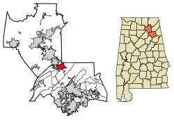
Sardis City is located in northern Etowah County at 34°10′26″N86°7′17″W / 34.17389°N 86.12139°W (34.173967, -86.121319). [5] A very small section of the town extends north into Marshall County. The town is bordered to the north by the city of Boaz. U.S. Route 431 passes through the west side of the town, leading northwest through Boaz 8 miles (13 km) to Albertville and southeast 17 miles (27 km) to Gadsden, the Etowah county seat.
According to the U.S. Census Bureau, Sardis City has a total area of 7.9 square miles (20.4 km2), of which 0.015 square miles (0.04 km2), or 0.20%, are water. [1] The town sits at 1,080 feet (330 m) above sea level atop the plateau of Sand Mountain. The town drains east to Short Creek, a north-flowing tributary of the Tennessee River. The Tennessee Valley Divide passes just west of the town limits.
Census | Pop. | Note | %± |
---|---|---|---|
1970 | 368 | — | |
1980 | 883 | 139.9% | |
1990 | 1,301 | 47.3% | |
2000 | 1,438 | 10.5% | |
2010 | 1,704 | 18.5% | |
2020 | 1,814 | 6.5% | |
U.S. Decennial Census [6] |
At the 2000 census there were 1,438 people, 572 households, and 458 families living in the town. The population density was 195.1 inhabitants per square mile (75.3/km2). There were 597 housing units at an average density of 81.0 units per square mile (31.3 units/km2). The racial makeup of the town was 99.10% White, 0.14% Black or African American, 0.07% Native American, 0.14% Pacific Islander, and 0.56% from two or more races. 0.63% of the population were Hispanic or Latino of any race. [7] Of the 572 households 32.2% had children under the age of 18 living with them, 68.7% were married couples living together, 8.4% had a female householder with no husband present, and 19.9% were non-families. 18.5% of households were one person and 9.6% were one person aged 65 or older. The average household size was 2.51 and the average family size was 2.82.
The age distribution was 22.2% under the age of 18, 9.3% from 18 to 24, 28.4% from 25 to 44, 26.1% from 45 to 64, and 14.0% 65 or older. The median age was 38 years. For every 100 females, there were 100.0 males. For every 100 females age 18 and over, there were 94.6 males.
The median household income was $36,000 and the median family income was $44,063. Males had a median income of $31,875 versus $21,711 for females. The per capita income for the town was $18,411. About 7.4% of families and 10.0% of the population were below the poverty line, including 11.9% of those under age 18 and 10.7% of those age 65 or over.
At the 2010 census there were 1,704 people, 657 households, and 509 families living in the town. The population density was 220 people per square mile (85 people/km2). There were 703 housing units at an average density of 89.0 units per square mile (34.4 units/km2). The racial makeup of the town was 98.2% White, 0.4% Black or African American, 0.1% Native American, 0.0% Pacific Islander, and 0.6% from two or more races. 0.7% of the population were Hispanic or Latino of any race. [8] Of the 657 households 31.2% had children under the age of 18 living with them, 63.0% were married couples living together, 10.2% had a female householder with no husband present, and 22.5% were non-families. 18.5% of households were one person and 10.5% were one person aged 65 or older. The average household size was 2.59 and the average family size was 2.97.
The age distribution was 24.4% under the age of 18, 6.8% from 18 to 24, 24.6% from 25 to 44, 28.1% from 45 to 64, and 16.1% 65 or older. The median age was 40.9 years. For every 100 females, there were 92.5 males. For every 100 females age 18 and over, there were 93.3 males.
The median household income was $45,714 and the median family income was $59,352. Males had a median income of $44,091 versus $28,333 for females. The per capita income for the town was $22,767. About 6.2% of families and 11.4% of the population were below the poverty line, including 8.9% of those under age 18 and 33.5% of those age 65 or over.
Race | Num. | Perc. |
---|---|---|
White (non-Hispanic) | 1,666 | 91.84% |
Black or African American (non-Hispanic) | 3 | 0.17% |
Native American | 1 | 0.06% |
Asian | 8 | 0.44% |
Other/Mixed | 63 | 3.47% |
Hispanic or Latino | 73 | 4.02% |
As of the 2020 United States census, there were 1,814 people, 686 households, and 481 families residing in the town.
Etowah County is a county located in the northeastern part of the U.S. state of Alabama. As of the 2020 census the population was 103,436. Its county seat is Gadsden. Its name is from a Cherokee word meaning "edible tree". In total area, it is the smallest county in Alabama, but one of the most densely populated. Etowah County comprises the Gadsden Metropolitan Statistical Area.
Altoona is a town in Etowah County in the U.S. state of Alabama. It is part of the Gadsden Metropolitan Statistical Area. At the 2020 census, the population was 948.
Glencoe is a city in Calhoun and Etowah counties in the U.S. state of Alabama. It is part of the Gadsden Metropolitan Statistical Area. The city incorporated in 1939. The population was 5,160 at the 2010 census.
Southside is a city located in Etowah County in the U.S. state of Alabama. It is included in the Gadsden Metropolitan Statistical Area. It incorporated in 1957. The population was 8,412 at the time of the 2010 United States Census. Located 8 to 12 miles south of downtown Gadsden, Southside is one of the fastest-growing cities in northeast Alabama. The current Mayor, elected in 2020, is Dana Snyder.
Hokes Bluff is a city in Etowah County, Alabama, United States. It is part of the Gadsden Metropolitan Statistical Area. At the 2020 census, the population was 4,446.
Rainbow City is a city in Etowah County, Alabama, United States. It incorporated in 1950. The population was 9,602 at the 2010 census. It is part of the Gadsden Metropolitan Statistical Area.
Ridgeville is a town in Etowah County, Alabama, United States. It incorporated in 1969 and is part of the Gadsden Metropolitan Statistical Area. At the 2020 census the population was 83, down from 158 in 2000. It is noteworthy for being the only community in Etowah County to have a black majority. Since 1970, it has also been the least populated community wholly within the county.
Walnut Grove is a town in Etowah County, Alabama, United States. It is part of the Gadsden Metropolitan Statistical Area. At the 2010 census the population was 698. From 1880 until the 1960 U.S. Census, with the exclusion of 1890 when no figure was reported, Walnut Grove had the distinction of being the least populated community wholly within Etowah County. It lost that distinction in 1970 to newly incorporated Ridgeville which has held the title since.
Ragland is a town in St. Clair County, Alabama, United States southeast of Ashville. It incorporated in 1899. At the 2020 census, the population was 1,693, up slightly from 1,639 in 2010. It is part of the Birmingham-Hoover-Cullman Combined Statistical Area.
Etowah is a town in Mississippi County, Arkansas, United States. The population was 254 at the 2020 census, down from 351 in 2010.
Dubois is a city in Clark County, Idaho, United States. The population was 511 at the 2020 census. The city is the county seat of Clark County.
Wahpeton is a city in Dickinson County, Iowa, United States. The population was 345 at the time of the 2020 census.
Sardis is a home rule-class city in Mason and Robertson counties in the U.S. state of Kentucky. The population was 60 as of the 2020 census, down from 103 in 2010.
New Vineyard is a town in Franklin County, Maine, United States. The population was 721 at the 2020 census.
Dames Quarter is a census-designated place (CDP) in Somerset County, Maryland, United States. The population was 188 at the 2000 census. It is included in the Salisbury, Maryland-Delaware Metropolitan Statistical Area.
Sardis is a town in Panola County, Mississippi. As of the 2020 census, the town population was 1,748. Sardis is one of two county seats for Panola County; the other is Batesville, on the south side of the Tallahatchie River.
Etowah is an unincorporated community and census-designated place (CDP) in Henderson County, North Carolina, United States. The population was 6,944 at the 2010 census. It is part of the Asheville Metropolitan Statistical Area.
Etowah is a town in Cleveland County, Oklahoma, United States. The population was 159 at the 2020 census, a 72.8% increase from 2010.
Fairfield is a town in Spokane County, Washington, United States. The population was 612 at the 2010 census.
Taylor is a village in Jackson County, Wisconsin, United States, along the Trempealeau River. The population was 484 at the 2020 census.