Schulte, Kansas | |
|---|---|
 | |
 Schulte  Schulte | |
| Coordinates: 37°37′23″N97°28′17″W / 37.62306°N 97.47139°W [1] | |
| Country | United States |
| State | Kansas |
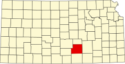
| County | Sedgwick |
| Elevation | 1,335 ft (407 m) |
| Time zone | UTC-6 (CST) |
| • Summer (DST) | UTC-5 (CDT) |
| Area code | 316 |
| FIPS code | 20-63450 [1] |
| GNIS ID | 474320 [1] |
Schulte is an unincorporated community in Sedgwick County, Kansas, United States. [1] It is located at K-42 (Southwest Boulevard) and MacArthur Rd.