Oaklawn-Sunview, Kansas

Last updated

Oaklawn-Sunview, Kansas
CDP
Sedgwick County Kansas Incorporated and Unincorporated areas Oaklawn-Sunview Highlighted.svg
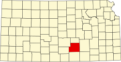
Location within Sedgwick County and Kansas
Map of Sedgwick Co, Ks, USA.png
USA Kansas location map.svg
Red pog.svg
Oaklawn-Sunview
Usa edcp location map.svg
Red pog.svg
Oaklawn-Sunview
Coordinates: 37°36′37″N97°17′49″W / 37.61028°N 97.29694°W / 37.61028; -97.29694 [1]
Country United States
State Kansas
County Sedgwick
Elevation
[1]
1,270 ft (390 m)
Population
 (2020) [2]
  Total2,880
Time zone UTC-6 (CST)
  Summer (DST) UTC-5 (CDT)
ZIP code
67216 [3]
Area code 316
FIPS code 20-51800 [1]
GNIS ID 474355 [1]

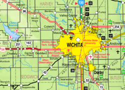
Oaklawn-Sunview is a census-designated place (CDP) in Sedgwick County, Kansas, United States. [1] As of the 2020 census, the population was 2,880. [2] It is located on the south side of Wichita along the west side of K-15 (Southeast Blvd) and 47th Street South intersection.

Contents

Geography

Oaklawn-Sunview is located at 37°36′30″N97°17′46″W / 37.60833°N 97.29611°W / 37.60833; -97.29611 (37.608463, -97.296045). [4] According to the United States Census Bureau, the community has a total area of 0.5 square miles (1.3 km2), all of it land.

Demographics

Historical population
CensusPop.Note
1990 3,240
2000 3,135−3.2%
2010 3,2764.5%
2020 2,880−12.1%
U.S. Decennial Census

2020 census

The 2020 United States census counted 2,880 people, 1,022 households, and 636 families in Oaklawn-Sunview. [5] [6] The population density was 5,363.1 per square mile (2,070.7/km2). There were 1,133 housing units at an average density of 2,109.9 per square mile (814.6/km2). [6] [7] The racial makeup was 51.49% (1,483) white or European American (43.09% non-Hispanic white), 4.06% (117) black or African-American, 3.3% (95) Native American or Alaska Native, 14.31% (412) Asian, 0.07% (2) Pacific Islander or Native Hawaiian, 13.44% (387) from other races, and 13.33% (384) from two or more races. [8] Hispanic or Latino of any race was 31.04% (894) of the population. [9]

Of the 1,022 households, 36.7% had children under the age of 18; 34.5% were married couples living together; 28.3% had a female householder with no spouse or partner present. 28.8% of households consisted of individuals and 10.9% had someone living alone who was 65 years of age or older. [6] The average household size was 2.6 and the average family size was 3.3. [10] The percent of those with a bachelor’s degree or higher was estimated to be 5.1% of the population. [11]

30.5% of the population was under the age of 18, 9.1% from 18 to 24, 27.8% from 25 to 44, 21.4% from 45 to 64, and 11.1% who were 65 years of age or older. The median age was 32.6 years. For every 100 females, there were 96.3 males. [6] For every 100 females ages 18 and older, there were 101.6 males. [6]

The 2016-2020 5-year American Community Survey estimates show that the median household income was $32,273 (with a margin of error of +/- $10,779) and the median family income was $40,000 (+/- $4,920). [12] Males had a median income of $26,195 (+/- $5,840) versus $23,611 (+/- $11,787) for females. The median income for those above 16 years old was $25,934 (+/- $6,104). [13] Approximately, 11.5% of families and 21.8% of the population were below the poverty line, including 11.1% of those under the age of 18 and 43.2% of those ages 65 or over. [14] [15]

2000 census

As of the census [16] of 2000, there were 3,135 people, 1,056 households and 785 families residing in the CDP. The population density was 5,823.1 inhabitants per square mile (2,248.3/km2). There were 1,179 housing units at an average density of 2,189.9 per square mile (845.5/km2). The racial makeup of the CDP was 62.7% White, 8.9% African American, 2.4% Native American, 15.5% Asian, <0.1% Pacific Islander, 5.4% from other races, and 5.1% from two or more races. Hispanic or Latino of any race were 11.4% of the population.

There were 1,056 households out of which 44.1% had children under the age of 18 living with them, 49.1% were married couples living together, 17.0% had a female householder with no husband present, and 25.6% were non-families. 20.3% of all households were made up of individuals, and 4.9% had someone living alone who was 65 years of age or older. The average household size was 2.97 and the average family size was 3.47.

In the CDP the population was spread out with 35.1% under the age of 18, 10.9% from 18 to 24, 30.6% from 25 to 44, 16.7% from 45 to 64, and 6.7% who were 65 years of age or older. The median age was 27 years. For every 100 females, there were 102.5 males. For every 100 females age 18 and over, there were 100.2 males.

The median income for a household in the CDP was $34,292 and the median income for a family was $35,978. Males had a median income of $30,956 and females $20,172. The per capita income was $12,564. About 16.2% of families and 18.3% of the population were below the poverty line, including 20.8% of those under age 18 and 22.2% of those age 65 or over.

Education

The community is served by Derby USD 260 public school district.

Related Research Articles

<span class="mw-page-title-main">Harris, Kansas</span> Unincorporated community in Anderson County, Kansas

Harris is a census-designated place (CDP) in Anderson County, Kansas, United States. As of the 2020 census, the population was 47.

<span class="mw-page-title-main">Meade, Kansas</span> City in Meade County, Kansas

Meade is a city in and the county seat of Meade County, Kansas, United States. As of the 2020 census, the population of the city was 1,505.

<span class="mw-page-title-main">Colwich, Kansas</span> City in Sedgwick County, Kansas

Colwich is a city in Sedgwick County, Kansas, United States, located northwest of Wichita. As of the 2020 census, the population of the city was 1,455.

<span class="mw-page-title-main">Mount Hope, Kansas</span> City in Sedgwick County, Kansas

Mount Hope is a city in Sedgwick County, Kansas, United States. As of the 2020 census, the population of the city was 806.

<span class="mw-page-title-main">Newport East, Rhode Island</span> CDP in Rhode Island, United States

Newport East is a census-designated place (CDP) in the town of Middletown, Newport County, Rhode Island, United States. The CDP encompasses the portion of the urban area of the city of Newport that extends beyond the municipal boundaries. The population of the CDP was 11,769 at the 2010 census.

<span class="mw-page-title-main">Greenville, Rhode Island</span> Census-designated place in Rhode Island, United States

Greenville is a village and census-designated place (CDP) in the town of Smithfield in Providence County, Rhode Island, United States. The population was 8,658 at the 2010 census. The CDP is centered on the village of Greenville but also encompasses the nearby villages of West Greenville and Spragueville, as well as the Mountaindale Reservoir and beach.

<span class="mw-page-title-main">Wakefield-Peacedale, Rhode Island</span> CDP in Rhode Island, United States

Wakefield-Peacedale is a census-designated place (CDP) in the town of South Kingstown in Washington County, Rhode Island, United States that includes the villages of Peace Dale and Wakefield. The population was 8,487 at the 2010 census.

<span class="mw-page-title-main">Pine Ridge, South Dakota</span> CDP in South Dakota, United States

Pine Ridge is a census-designated place (CDP) and the most populous community in Oglala Lakota County, South Dakota, United States. The population was 3,138 at the 2020 census. It is the tribal headquarters of the Oglala Sioux Tribe on the Pine Ridge Indian Reservation.

<span class="mw-page-title-main">Lakehills, Texas</span> CDP in Texas, United States

Lakehills is a census-designated place (CDP) in Bandera County, Texas, United States. The population was 5,295 at the 2020 census, making it the most populous place in Bandera County. It is part of the San Antonio Metropolitan Statistical Area.

<span class="mw-page-title-main">Westerly (CDP), Rhode Island</span> CDP in Rhode Island, United States

Westerly is a census-designated place (CDP) in the town of Westerly in Washington County, Rhode Island, United States. The population was 17,682 at the 2000 census. The CDP includes the majority of the town of Westerly's population, with only the rural eastern and coastal southern portions of towns excluded.

<span class="mw-page-title-main">Home, Kansas</span> Unincorporated community in Marshall County, Kansas

Home is a census-designated place (CDP) in southern Franklin Township, Marshall County, Kansas, United States. As of the 2020 census, the population was 154. It lies along U.S. Route 36 – the Pony Express Highway – and a Union Pacific rail line, east of the city of Marysville.

<span class="mw-page-title-main">Baileyville, Kansas</span> Unincorporated community in Nemaha County, Kansas

Baileyville is a census-designated place (CDP) in western Nemaha County, Kansas, United States. As of the 2020 census, the population was 182. It is located six miles west of Seneca on U.S. Route 36.

<span class="mw-page-title-main">Milton, Kansas</span> Unincorporated community in Sumner County, Kansas

Milton is a census-designated place (CDP) in Sumner County, Kansas, United States. As of the 2020 census, the population was 155. It is located 4.5 miles (7.2 km) southeast of Norwich at the intersection of N Argonia Rd and W 120th Ave N, next to the railroad.

<span class="mw-page-title-main">Fort Dodge, Kansas</span> Unincorporated community in Ford County, Kansas

Fort Dodge is a census-designated place (CDP) in Grandview Township, Ford County, Kansas, United States. As of the 2020 census, the population was 97. It is located on U.S. Route 400 5 miles (8 km) southeast of Dodge City. Fort Dodge has a post office with ZIP code 67843.

<span class="mw-page-title-main">Hallowell, Kansas</span> Unincorporated community in Cherokee County, Kansas

Hallowell is a census-designated place (CDP) in Cherokee County, Kansas, United States. As of the 2020 census, the population was 101.

<span class="mw-page-title-main">Odin, Kansas</span> Unincorporated community in Barton County, Kansas

Odin a census-designated place (CDP) in Barton County, Kansas, United States. As of the 2020 census, the population was 87. It is located northwest of Claflin at the intersection of NE 140 Rd and NE 90 Ave.

<span class="mw-page-title-main">Kickapoo Tribal Center, Kansas</span> Unincorporated community in Brown County, Kansas

Kickapoo Tribal Center is a census-designated place (CDP) in Brown County, Kansas, United States, on the Kickapoo Indian Reservation. As of the 2020 census, the population was 177, making it the most populous location within the reservation.

<span class="mw-page-title-main">Radley, Kansas</span> Unincorporated community in Crawford County, Kansas

Radley is a census-designated place (CDP) in Crawford County, Kansas, United States. As of the 2020 census, the population was 105.

<span class="mw-page-title-main">Herkimer, Kansas</span> Unincorporated community in Marshall County, Kansas

Herkimer is a census-designated place (CDP) in Marshall County, Kansas, United States. As of the 2020 census, the population was 54.

<span class="mw-page-title-main">Niles, Kansas</span> Unincorporated community in Ottawa County, Kansas

Niles is a census-designated place (CDP) in Ottawa County, Kansas, United States. As of the 2020 census, the population was 56.

References

  1. 1 2 3 4 5 "Oaklawn, Kansas", Geographic Names Information System , United States Geological Survey, United States Department of the Interior
  2. 1 2 "Profile of Oaklawn-Sunview, Kansas (CDP) in 2020". United States Census Bureau. Archived from the original on November 14, 2021. Retrieved November 14, 2021.
  3. "Oaklawn-Sunview KS ZIP Code". zipdatamaps.com. 2024. Retrieved February 5, 2024.
  4. "US Gazetteer files: 2010, 2000, and 1990". United States Census Bureau. February 12, 2011. Retrieved April 23, 2011.
  5. "US Census Bureau, Table P16: HOUSEHOLD TYPE". data.census.gov. Retrieved January 3, 2024.
  6. 1 2 3 4 5 "US Census Bureau, Table DP1: PROFILE OF GENERAL POPULATION AND HOUSING CHARACTERISTICS". data.census.gov. Retrieved January 3, 2024.
  7. Bureau, US Census. "Gazetteer Files". Census.gov. Retrieved December 30, 2023.
  8. "US Census Bureau, Table P1: RACE". data.census.gov. Retrieved January 3, 2024.
  9. "US Census Bureau, Table P2: HISPANIC OR LATINO, AND NOT HISPANIC OR LATINO BY RACE". data.census.gov. Retrieved January 3, 2024.
  10. "US Census Bureau, Table S1101: HOUSEHOLDS AND FAMILIES". data.census.gov. Retrieved January 3, 2024.
  11. "US Census Bureau, Table S1501: EDUCATIONAL ATTAINMENT". data.census.gov. Retrieved January 3, 2024.
  12. "US Census Bureau, Table S1903: MEDIAN INCOME IN THE PAST 12 MONTHS (IN 2020 INFLATION-ADJUSTED DOLLARS)". data.census.gov. Retrieved January 3, 2024.
  13. "US Census Bureau, Table S2001: EARNINGS IN THE PAST 12 MONTHS (IN 2020 INFLATION-ADJUSTED DOLLARS)". data.census.gov. Retrieved January 3, 2024.
  14. "US Census Bureau, Table S1701: POVERTY STATUS IN THE PAST 12 MONTHS". data.census.gov. Retrieved January 3, 2024.
  15. "US Census Bureau, Table S1702: POVERTY STATUS IN THE PAST 12 MONTHS OF FAMILIES". data.census.gov. Retrieved January 3, 2024.
  16. "U.S. Census website". United States Census Bureau . Retrieved January 31, 2008.

Further reading