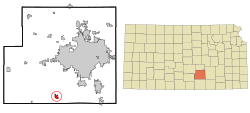
2020 census
The 2020 United States census counted 2,653 people, 934 households, and 689 families in Clearwater. [10] [11] The population density was 1,369.6 per square mile (528.8/km2). There were 985 housing units at an average density of 508.5 units per square mile (196.3 units/km2). [11] [12] The racial makeup was 90.88% (2,411) white or European American (89.6% non-Hispanic white), 0.19% (5) black or African-American, 0.83% (22) Native American or Alaska Native, 0.26% (7) Asian, 0.0% (0) Pacific Islander or Native Hawaiian, 0.64% (17) from other races, and 7.2% (191) from two or more races. [13] Hispanic or Latino of any race was 3.69% (98) of the population. [14]
Of the 934 households, 41.8% had children under the age of 18; 56.9% were married couples living together; 24.3% had a female householder with no spouse or partner present. 21.6% of households consisted of individuals and 11.7% had someone living alone who was 65 years of age or older. [11] The average household size was 2.9 and the average family size was 3.5. [15] The percent of those with a bachelor's degree or higher was estimated to be 17.7% of the population. [16]
30.1% of the population was under the age of 18, 6.8% from 18 to 24, 24.5% from 25 to 44, 21.6% from 45 to 64, and 16.9% who were 65 years of age or older. The median age was 35.8 years. For every 100 females, there were 108.1 males. [11] For every 100 females ages 18 and older, there were 114.3 males. [11]
The 2016-2020 5-year American Community Survey estimates show that the median household income was $73,073 (with a margin of error of +/- $6,251) and the median family income was $84,167 (+/- $10,596). [17] Males had a median income of $48,620 (+/- $5,156) versus $33,269 (+/- $4,364) for females. The median income for those above 16 years old was $39,757 (+/- $5,937). [18] Approximately, 7.8% of families and 9.0% of the population were below the poverty line, including 12.8% of those under the age of 18 and 1.5% of those ages 65 or over. [19] [20]
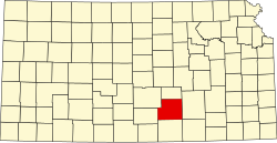
2010 census
As of the census [21] of 2010, there were 2,481 people, 908 households, and 660 families residing in the city. The population density was 1,326.7 inhabitants per square mile (512.2/km2). There were 963 housing units at an average density of 515.0 units per square mile (198.8 units/km2). The racial makeup of the city was 97.2% White, 0.2% African American, 0.3% Native American, 0.3% Asian, 0.3% from other races, and 1.7% from two or more races. Hispanic or Latino of any race were 1.6% of the population.
There were 908 households, of which 40.9% had children under the age of 18 living with them, 56.1% were married couples living together, 11.5% had a female householder with no husband present, 5.2% had a male householder with no wife present, and 27.3% were non-families. 25.3% of all households were made up of individuals, and 14.2% had someone living alone who was 65 years of age or older. The average household size was 2.65 and the average family size was 3.19.
The median age in the city was 35.8 years. 29.6% of residents were under the age of 18; 7.3% were between the ages of 18 and 24; 24.7% were from 25 to 44; 22% were from 45 to 64; and 16.5% were 65 years of age or older. The gender makeup of the city was 47.1% male and 52.9% female.