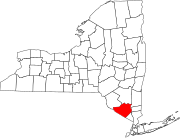
Scotts Corner is a hamlet in Orange County, in the U.S. state of New York. [1]
Orange County is a county located in the U.S. state of New York. As of the 2010 census, the population was 372,813. The county seat is Goshen. This county was first created in 1683 and reorganized with its present boundaries in 1798.
In the United States, a state is a constituent political entity, of which there are currently 50. Bound together in a political union, each state holds governmental jurisdiction over a separate and defined geographic territory and shares its sovereignty with the federal government. Due to this shared sovereignty, Americans are citizens both of the federal republic and of the state in which they reside. State citizenship and residency are flexible, and no government approval is required to move between states, except for persons restricted by certain types of court orders. Four states use the term commonwealth rather than state in their full official names.
New York is a state in the Northeastern United States. New York was one of the original Thirteen Colonies that formed the United States. With an estimated 19.54 million residents in 2018, it is the fourth most populous state. To distinguish the state from the city in the state with the same name, it is sometimes called New York State.
The community was named after John F. Scott, the proprietor of a store at the local crossroads. [2] A variant name is "Scott's Corners". [1]
Wawayanda Creek is the name of Pochuck Creek above its confluence with the tributary Black Creek.
Pochuck Creek is an 8.1-mile-long (13.0 km) tributary of the Wallkill River in Orange County, New York and Sussex County, New Jersey, in the United States.
Area code 845 is a telephone area code straddling the Hudson Valley region of the U.S. state of New York. 845 serves Rockland, Putnam, Orange, and Ulster counties, and parts of Dutchess and Sullivan, Delaware, Greene, and Columbia counties. Area code 845 was created on June 5, 2000, from most of area code 914, which was retained by Westchester County. It is the only area code to serve communities in both Upstate and Downstate NY.
Michigan Corners, New York is a hamlet near Scotchtown east of Middletown, located at the corner of New York State Route 211 and Goshen Turnpike.
Slate Hill is one of the eight hamlets found in the town of Wawayanda, New York. It is home to the Minisink Valley Central School District. Slate Hill is found in Orange County, New York, one of the fastest-growing counties in the state. The area, along with its surrounding regions and the county in which it resides, has seen a recent surge in population growth that can be partially attributed to suburbanization from the New York City metropolitan area. This growth reached a peak in the post 9/11 era, but has since seen a decrease in the past 3 years.
Circleville, New York is a hamlet in the Town of Wallkill, part of Orange County, New York, United States. It is located on NY 302 around the junction with the old Goshen Turnpike, a short distance north of NY 17 and two miles (3 km) south of Bullville. It is three miles (5 km) northeast of Middletown.
Ridgebury, New York is one of the eight Hamlets in the town of Wawayanda, New York. The hamlet and its township are located in Orange County, New York, approximately 65 miles north of New York City.
Black Meadow Creek is a 9.7-mile-long (15.6 km) tributary of the Otter Kill in Orange County, New York, in the United States. Via the Otter Kill, it is part of the Moodna Creek watershed, flowing onward to the Hudson River, in one of New York State's most biodiverse natural areas. Home to 13 species of salamander as well as to New York's largest population of the Northern Cricket Frog, the state's only listed "Endangered" frog species, the creek area is considered by biologists to be one of the state's herpetological "hot spots". Black Meadow Creek has several confirmed bald eagle nests along its length.
Hume is an unincorporated community in Allen County, in the U.S. state of Ohio.
Belden is an extinct town in Eagle County, in the U.S. state of Colorado. The GNIS classifies it as a populated place.
Dry Fork is a stream in Crawford, Dent and Phelps counties in the Ozarks of Missouri. It is a tributary of the Meramec River.
Mumford is an unincorporated community in Greene County, in the U.S. state of Missouri. The community was located at the junction of Jones Branch and Pierson Creek about 1.3 miles east of the current U.S. 65 bypass of east Springfield. The old St. Louis - San Francisco Railroad passes just southwest of the location. The old Mt. Pisgah School was located just to the north.
Aldine is an unincorporated community in California Township, Starke County, in the U.S. state of Indiana.
Huguenot is a hamlet in the town of Deerpark, in Orange County, New York. It is north of Port Jervis on US-209. Huguenot Schoolhouse and Neversink Valley Grange Hall No. 1530 are listed on the National Register of Historic Places. The community was named after Huguenot immigrants.
Little Pond is a lake in Orange County, in the U.S. state of New York. The pond has a surface area of 6 acres (2.4 ha).
Coldenham is a hamlet in Orange County, in the U.S. state of New York.
Saint Andrew is a hamlet in Orange County, in the U.S. state of New York.
New Vernon is a hamlet in Orange County, in the U.S. state of New York.
South Centerville is a hamlet in Orange County, in the U.S. state of New York.
Sioux Township is a township in Plymouth County, Iowa in the United States. The township is named after.
Coordinates: 41°31′32″N74°12′03″W / 41.52556°N 74.20083°W
A geographic coordinate system is a coordinate system that enables every location on Earth to be specified by a set of numbers, letters or symbols. The coordinates are often chosen such that one of the numbers represents a vertical position and two or three of the numbers represent a horizontal position; alternatively, a geographic position may be expressed in a combined three-dimensional Cartesian vector. A common choice of coordinates is latitude, longitude and elevation. To specify a location on a plane requires a map projection.
This article about a location in Orange County, New York is a stub. You can help Wikipedia by expanding it. |