Crawford is a town in the north of Orange County, New York, United States. The population was 9,130 at the 2020 census. The name comes from a settler who gave his name to a community in the hamlet now called Pine Bush.

Pine Bush is a hamlet located in the town of Crawford and adjacent to Shawangunk, New York, within Orange and adjacent to Ulster counties in the U.S. It is roughly coterminous with the 12566 ZIP code and 744 telephone exchange in the 845 area code. These both extend into adjacent regions of the town of Shawangunk in Ulster County.. The population was 1,751 at the 2020 census.

Shawangunk is a town in southwestern Ulster County, New York, United States. The population was 13,563 at the 2020 census. The town takes its name from its largest stream, the Shawangunk Kill. The name Shawangunk is from the language of the Lenape people. Kill is an abbreviation of the Dutch word for creek, Killitje. It is pronounced Shuh-Whan-Gung

Wawarsing is a town in Ulster County, New York, United States. The population was 12,771 at the 2020 census. The name Wawarsing was once believed to mean "a place where the streams wind" in the Lenape language, referring to the geography in the hamlet of Wawarsing. Specifically, the joining of the Ver Nooy Kill and the Rondout Creek at Port Ben. The name Wawarsing was used by the Lenape to designate the current hamlet and the fields to the north and south of it for at least six miles in both directions. It is the only Lenape name known to refer to an exact location in Ulster County.
The Mohonk Preserve is a nature preserve in the Shawangunk Ridge, 90 miles (140 km) north of New York City in Ulster County, New York. The preserve has over 8,000 acres (32 km2) of cliffs, forests, fields, ponds and streams, with over 70 miles (110 km) of carriage roads and 40 miles (64 km) of trails for hiking, cycling, trail running, cross-country skiing, snowshoeing, and horseback riding. It is also a major destination for rock climbers, hosting 50,000 climbers each year who enjoy more than 1,000 climbing routes.
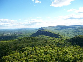
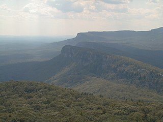
The Shawangunk Ridge, also known as the Shawangunk Mountains or The Gunks, is a ridge of bedrock in Ulster County, Sullivan County and Orange County in the state of New York, extending from the northernmost point of the border with New Jersey to the Catskills. The Shawangunk Ridge is a continuation of the long, easternmost section of the Appalachian Mountains; the ridge is known as Kittatinny Mountain in New Jersey, and as Blue Mountain as it continues through Pennsylvania. This ridge constitutes the western border of the Great Appalachian Valley.

New York State Route 302 (NY 302) is a state highway in northern Orange County, New York, in the United States. The southern terminus of the route is at an intersection with NY 17M north of the city of Middletown in the town of Wallkill. Its northern terminus is at a junction with NY 52 in the hamlet of Pine Bush, located within the town of Crawford.
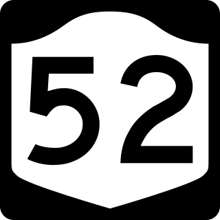
New York State Route 52 (NY 52) is a 108.72-mile-long (174.97 km) state highway in the southeastern part of the state. It generally runs from west to east through five counties, beginning at the Pennsylvania state line in the Delaware River near Narrowsburg, crossing the Hudson River on the Newburgh–Beacon Bridge, and ending in Carmel. NY 52 and NY 55, both major east–west routes of the Mid-Hudson Region, run parallel to each other, intersecting in downtown Liberty.

New York State Route 208 (NY 208) is a state highway located in southern New York in the United States. The southern terminus is at an intersection with NY 17M in the Orange County village of Monroe. Its northern terminus is located at an intersection with NY 32 and NY 299 in the Ulster County village of New Paltz.
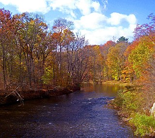
The Shawangunk Kill is a 47.2-mile-long (76.0 km) stream that flows northward through Orange, Sullivan and Ulster counties, New York, in the United States. It is the largest tributary of the Wallkill River.

The Taylor–Corwin House, also the Falconer Inn, is a Registered Historic Place in Pine Bush, New York. It is located at 112 Maple Street, a few houses south of its intersection with NY 52.

The Alexander Thompson House is one of several originally built by members of the Thompson family in Thompson Ridge, a hamlet in the Town of Crawford in Orange County, New York. It is located, like the others, along NY 302 just south of the intersection with Thompson Ridge Road.
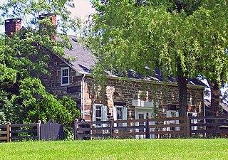
The Robert A. Thompson House is located along NY 302 in the Thompson Ridge section of the Orange County, New York, town of Crawford. It was built in 1822 in the Federal style. One of the stones in the northwest cable bears his initials and that date. His descendants established the Dutch-Belt dairy farm, which still operates.

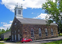
The Hopewell Presbyterian Church is a historic Presbyterian church located at the junction of Thompson Ridge Road and NY 302 in the Thompson Ridge section of the Town of Crawford in Orange County, New York.

The Wallkill Valley Rail Trail is a 23.7-mile (38.1 km) rail trail and linear park that runs along the former Wallkill Valley Railroad rail corridor in Ulster County, New York, United States. It stretches from Gardiner through New Paltz, Rosendale and Ulster to the Kingston city line, just south of a demolished, concrete Conrail railroad bridge that was located on a team-track siding several blocks south of the also-demolished Kingston New York Central Railroad passenger station. The trail is separated from the Walden–Wallkill Rail Trail by two state prisons in Shawangunk, though there have been plans to bypass these facilities and to connect the Wallkill Valley Rail Trail with other regional rail-trails. The northern section of the trail forms part of the Empire State Trail.

Spring Glen is a hamlet of the Town of Wawarsing in Ulster County, New York, United States. It is located just off US 209 just north of the Sullivan County line. It sits along the Sandburg Creek and has a direct access point for parking and hiking to the highest point of the Shawangunk Ridge Trail at over 1800 feet. It has the ZIP Code 12483.

The John I. Crawford Farm, also Hopewell Farm, is located on NY 302 in the Thompson Ridge section of the Town of Crawford in Orange County, New York, United States. It has been on the National Register of Historic Places since 1998.

The Dwaar Kill is a 17-mile-long (27 km) tributary of the Wallkill River that drains a 28-square-mile (73 km2) area of Orange and Ulster counties in the U.S. state of New York. It is the Wallkill's second-longest tributary after the Shawangunk Kill, whose course it parallels somewhat to the east.

The Walden–Wallkill Rail Trail, also known as the Jesse McHugh Rail Trail, is a 3.22-mile (5.18 km) rail trail between the village of Walden, New York and the neighboring hamlet of Wallkill. The two communities are located in Orange and Ulster counties, respectively, in upstate New York.
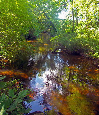
The Verkeerder Kill, sometimes Verkeerderkill and locally shortened to Kaidy Kill is an 8-mile-long (13 km) stream in Ulster County, New York, United States. It rises on the Shawangunk Ridge, in the town of Wawarsing, and flows southwards through the town of Shawangunk, toward the Shawangunk Kill, itself a major tributary of the Wallkill River. Ultimately it is a part of the Hudson River's watershed.