Washington Heights, New York | |
---|---|
Coordinates: 41°28′N74°24′W / 41.467°N 74.400°W Coordinates: 41°28′N74°24′W / 41.467°N 74.400°W | |
Country | United States |
State | New York |
County | Orange |
Area | |
• Total | 1.48 sq mi (3.82 km2) |
• Land | 1.47 sq mi (3.81 km2) |
• Water | 0.01 sq mi (0.01 km2) |
Elevation | 666 ft (203 m) |
Population (2020) | |
• Total | 2,205 |
• Density | 1,498.98/sq mi (578.64/km2) |
Time zone | UTC-5 (Eastern (EST)) |
• Summer (DST) | UTC-4 (EDT) |
FIPS code | 36-78421 [2] |
GNIS feature ID | 0968847 [3] |
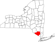
Washington Heights is a census-designated place (CDP) in Orange County, New York, United States. The population was 2,205 at the 2020 census.
Washington Heights is a contiguous suburb of City of Middletown. The community is in the Town of Wallkill.
Washington Heights is located at 41°28′02″N74°24′40″W / 41.4671°N 74.4112°W . [4]
According to the United States Census Bureau, the CDP has a total area of 1.5 square miles (3.9 km2), all land.
As of the census [2] of 2000, there were 1,318 people, 492 households, and 348 families living in the CDP. The population density was 874.3 per square mile (337.0/km2). There were 510 housing units at an average density of 338.3/sq mi (130.4/km2). The racial makeup of the CDP was 84.60% White, 7.74% African American, 0.83% Native American, 1.52% Asian, 3.34% from other races, and 1.97% from two or more races. Hispanic or Latino of any race were 10.62% of the population.
There were 492 households, out of which 33.1% had children under the age of 18 living with them, 53.7% were married couples living together, 12.6% had a female householder with no husband present, and 29.1% were non-families. 23.2% of all households were made up of individuals, and 10.6% had someone living alone who was 65 years of age or older. The average household size was 2.68 and the average family size was 3.16.
In the CDP, the population was spread out, with 26.3% under the age of 18, 6.8% from 18 to 24, 31.3% from 25 to 44, 23.0% from 45 to 64, and 12.7% who were 65 years of age or older. The median age was 36 years. For every 100 females, there were 89.9 males. For every 100 females age 18 and over, there were 85.1 males.
The median income for a household in the CDP was $42,981, and the median income for a family was $52,125. Males had a median income of $30,813 versus $26,023 for females. The per capita income for the CDP was $17,929. About 7.4% of families and 5.3% of the population were below the poverty line, including 7.0% of those under age 18 and 5.3% of those age 65 or over.
Historical population | |||
---|---|---|---|
Census | Pop. | %± | |
1990 | 1,159 | — | |
2000 | 1,318 | 13.7% | |
2010 | 1,689 | 28.1% | |
2020 | 2,205 | 30.6% | |
U.S. Decennial Census [4] |
Central Heights-Midland City is an unincorporated community and census-designated place (CDP) in Gila County, Arizona, United States. The area is home to the Pinal Cemetery which serves the community in gereneral but also contains Croatian and Serbian dedicated sections. The Gila County Health and Human Services offices are located within the region. One of the communities few nurseries is located along Golden Hill Road, a notable road in the Central Heights-Midland City area. The population was 2,534 at the 2010 census.
Ridge Wood Heights is a census-designated place (CDP) in Sarasota County, Florida, United States. The population was 4,795 at the 2010 United States Census. It is part of the Bradenton–Sarasota–Venice Metropolitan Statistical Area.
Long Lake is an unincorporated community and census-designated place (CDP) in Lake County, Illinois, United States. Per the 2020 census, the population was 3,663.
Preston Heights is a census-designated place (CDP) in Will County, Illinois, United States. As of the 2020 census, the CDP population was 2,898.
Gulivoire Park is a census-designated place (CDP) in Centre Township, St. Joseph County, in the U.S. state of Indiana. The population was 2,974 at the 2000 census. It is part of the South Bend–Mishawaka, IN-MI, Metropolitan Statistical Area.
Benton Heights is an unincorporated community in Berrien County in the U.S. state of Michigan. It is also a census-designated place (CDP) for statistical purposes without any legal status as an incorporated municipality. Per the 2020 Census, the population was 3,652.The community is a part of Benton Charter Township and is adjacent to the city of Benton Harbor.
North Woodbridge was a former census-designated place (CDP) in San Joaquin County, California, United States. The population was 1,320 at the 2000 census. For the 2010 census, the CDP's of South Woodbridge and North Woodbridge were merged into Woodbridge.
Holiday Heights is an unincorporated community and census-designated place (CDP) located within Berkeley Township, in Ocean County, New Jersey, United States. As of the 2010 United States Census, the CDP's population was 2,099.
Crown Heights is a hamlet and census-designated place (CDP) in Dutchess County, New York, United States. The population was 2,840 at the 2010 census. It is part of the Poughkeepsie–Newburgh–Middletown, NY Metropolitan Statistical Area as well as the larger New York–Newark–Bridgeport, NY-NJ-CT-PA Combined Statistical Area.
Shelter Island Heights is a hamlet and census-designated place (CDP) located in the Town of Shelter Island, Suffolk County, New York, United States. It is located on the north side of the island of Shelter Island, surrounding the village of Dering Harbor. The population was 1,048 at the 2010 census.
Clintondale is a hamlet in Ulster County, New York, United States. The population was 1,452 at the 2010 census.
Lenape Heights is a census-designated place (CDP) in Armstrong County, Pennsylvania, United States. The population was 1,167 at the 2010 census.
Cornwells Heights-Eddington was a census-designated place (CDP) in Bucks County, Pennsylvania, United States. The population was 3,406 at the 2000 census. For the 2010 census, the area was split into two CDPs, Cornwells Heights and Eddington, that are adjacent unincorporated communities within Bensalem Township. Cornwells Heights is located a bit southwest of Eddington. Both communities use the Bensalem ZIP code, 19020.
Woodside is a census-designated place (CDP) in Bucks County, Pennsylvania, United States. The population was 2,425 at the 2010 census.
Hyde is an unincorporated community and census-designated place (CDP) in Clearfield County, Pennsylvania, United States. The population was 1,303 at the 2020 census.
Arlington Heights is a census-designated place (CDP) in Monroe County, Pennsylvania, United States. The population was 6,333 at the 2010 census. One notable location in Arlington Heights is the Stroud Mall.
Palmer Heights is a census-designated place (CDP) in Palmer Heights, Pennsylvania. The population of Palmer Heights was 3,762 at the 2010 census. Palmer Heights is part of the Lehigh Valley, which has a population of 861,899 and is the 68th most populated metropolitan area in the U.S. as of the 2020 census.
Sheppton is a census-designated place (CDP) in Schuylkill County, Pennsylvania, United States. The population was 239 at the 2000 census. The Mayor of Sheppton is Scott Yagielniskie, who has so been since 2014.
Woodland Heights is a census-designated place (CDP) in Venango County, Pennsylvania, United States. The population was 1,402 at the 2000 census.
Brunswick is a census-designated place (CDP) in the town of Brunswick in Cumberland County, Maine, United States. The population was 15,175 at the 2010 census. It is part of the Portland–South Portland–Biddeford, Maine Metropolitan Statistical Area.